Thursday, April 4, 2019

Week 2: Vinales Valley (Cuba)


Last year I went to Cuba for a J-Term my classmates and I were there for about nine days all together. This picture was taken at Vinales Valley we had to do a lot of driving this day to get to this view, but getting this picture was worth the ride. In doing some research, I found that millions of years ago the bottom of the sea was lifted and a lime stone mountain chain was formed. The story goes on to say that due to erosion big caves were created until their roofs collapsed, which is when valleys were formed.

This picture is just one of the mountains that we seen when we made our trip to Vinales Valley. The rocks on this mountain were very hard and there were even some caves that we got to explore on a boat (which is the second picture)


References: Team, IonizeCMS. “Valley of Viñales.” Valley of Viñales in Cuba |, www.cubafortravel.com/individually/best-visits/valley-of-viales.

I finally got access to the blog (test posting)

I have been having the hardest time getting access to this blog, but it seems like I finally can make a post now. So here is my test post.

Tuesday, April 2, 2019

Week 4 - Volcanoes-Manua Kea

When I was 11, I took a helicopter tour with my parents over Mauna Kea, a volcano on the Big Island of Hawaii. Mauna Kea is a dormant volcano with a peak above sea level making it the highest point in Hawaii. When it's measured from its oceanic base, Mauna Kea the tallest mountain in the world! The most “recent” eruption was about 4,000 years ago, 2460 B.C. It is commonly known to be in its “post-shield” stage meaning as the volcano moves off the hotspot, the lava production slows down leading to a reduced eruption rate. The post-shield alkalic stage reduces the thermal productivity and eventually the “magma chamber” hardens due to a lack of replenishment.
           Mauna Kea is currently measured as a volcano displaying quiescence. The quiescent periods between eruptions are long compared to those of the active volcanos on the island (such as Mauna Loa and Kilauea). The eruptive history began to build from the sea floor around 0.8 million years ago. There are swarms of earthquakes beneath Mauna Kea that might signal an eruption can occur, but, such swarms do not always result in an eruption. There is no foretelling of a future eruption, but the island is prepared for any potential result.
            Some hazards from Mauna Kea include altitude sickness, sunburn, eye damage, and impaired judgment. There are also weather hazards which include server winds over 100 miles per hour and snow storms. I do remember the training before the tour. The team went over the hazards until they were engraved in everyone’s mind. I do remember being scared about going over this volcano, but it was a site to see. It looks like God’s thumb squished a pile of dirt, leaving an imprint behind. I do remember not being very interested in the views, unlike my parents who snapped photos left and right. When I look back, I wish I could experience the tour all over again!
            I do remember the locals warning us not to take the volcano rock home. Apparently, there is a myth that if you take the rock, you will have bad luck. My mom, being the superstitious one was very cautious about me taking home any souvenirs! According to the news clipping my mom kept, it states that Mauna Kea is a great place to ski and snowboard! I didn’t know that a dormant volcano could be a place to do these activities! It also specified that Mauna Kea is the home to the world’s most powerful telescopes and astronomical observations. Being the tallest mountain in the world, I believe this would be a perfect place to stargaze. One day, I will visit Mauna Kea again.
**NOTE** Mauna Kea has a lower altitude than Mount Everest. It would be considered “taller” whereas ME is the world’s “highest” mountain in the world due to its higher elevation above sea level. 

Please excuse my dad’s silly face. These photos were taken on my mom’s camera and glued in her photo album, the news article and clippings are from the tour brochure.


References:
            Mauna Kea Hazards. (n.d.). Retrieved from http://www.ifa.hawaii.edu/mko/hazards.htm

            Volcano World. (n.d.). Retrieved from http://volcano.oregonstate.edu/post-shield-alkalic-stage

            Multiple. (n.d.). Retrieved from https://www.soest.hawaii.edu/GG/HCV/maunakea.html


Monday, April 1, 2019

Week 4 - Volcanoes - Kilauea


I recently visited the Big Island of Hawaii and witnessed the destructive power of the shield volcano known as Kilauea.

Kilauea, as with other Hawaiian volcanoes was not formed at diverging or converging plates, but rather the result of hot spots within the mantle that resulted in the outpouring of basalt onto the Earth's surface.

Kilauea is a shield volcano, characterized by its shallow gradient. Shield volcanoes often form due to the release of highly viscous lava that is able to travel large distances over a shallow gradient. These lava flows typically have high silica and gas content which results in its fluidity. Lava like this, referred to as pahoehoe by Hawaiians, often travel in lava tubes which allow the flowing lava to retain heat, thus allowing it to travel further.

Kilauea erupted continuously from 1983 until September 2018 after an explosive eruption from its vents destroyed hundreds of homes in May 2018.

According to the USGS, Kilauea is still an active volcano but most likely won't erupt again for several more years. Because it is still active, it should still be seen as a threat in the area.

Image result for kilauea
Image retrieved from https://www.theatlantic.com/photo/2018/06/photo-updates-from-kilauea-dozens-more-homes-destroyed/562241/


Sources:


Sunday, March 31, 2019

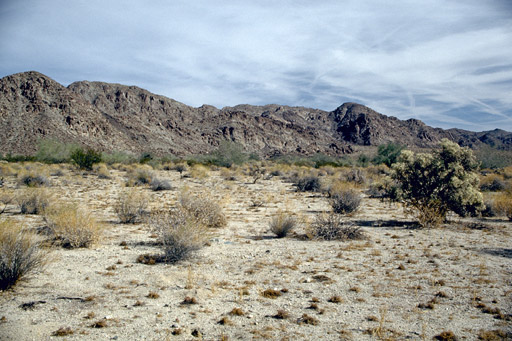
Week 3- Colorado Desert

A desert is a region where little precipitation occurs and living conditions are hostile for plants and animals. Deserts cover about one fifth of the earths surface. Deserts are part of a wider class of regions called dry lands. These areas exist under a moisture deficit, which means they frequently lose more moisture through evaporation than they receive from annual precipitation. 
Image result for colorado desert
The Colorado Desert is part of the Sonoran Desert. It extends from southeastward for 164 miles from the San Gorgonio pass in southeastern California, to the Colorado River delta in northern Mexico. The climate in the Colorado Desert is different from other deserts because the region experiences greater summer daytime temperatures than higher-elevation deserts and almost never experiences frost. The Colorado desert typically experiences two rainy seasons per year, in the winter and late summer. This regions geology is dominated by the transition of the tectonic plate boundary from rift to fault. This area is subjected to earthquakes, and the crust is being stretched which will cause sinking of the terrain over time. 

Week 3 - Glaciers - Valero

A glacier is a very slowly moving river of ice, in which the snow in the glacier accumulation area accumulates quicker than it runs off. Each year, more snow is added into the glacier, which accumulates and compresses the residual snow from previous years. The compaction forms ice over time.

The ice in glaciers bends and flows slowly towards downslope melting areas, much like a river. Also like a river, glaciers contribute to the geological erosion process by moving rocks and sediment downstream. Glaciers form in areas where there is heavy snowfall and low runoff, and such areas exist in our own state!


Tyndall Glacier is a small circular glacier in the Rocky Mountain National Park. It's located just East of the continental divide near Hallett peak, about 2 hours from Denver.

A terrific geological feature of Tyndall Glacier is that it is composed mostly of rock near it's base, and is composed more and more of ice near the top of the glacier. This is a clear demonstration of the river-like erosive properties of glaciers.


Week 3 - Perito Moreno Glacier, Argentina


Perito Moreno Glacier is located 48 miles from the town of El Calafate. This Glacier is a huge tourist attraction and can be seen by boat on Lake Argentino or by three viewing areas on land. This glacier is the third largest reserve of fresh water and periodically chunks of the glacier fall into Lake Argentino. While the majority of glaciers around the world, this glacier is actually advancing. This is especially remarkable because of all the talks about "global warming." Although pieces of ice break off, it still gains more ice than it is losing. Most glaciers melt into the ocean but this one melts into a lake and this process is called calving. The Perito Moreno Glacier also abrade rock and debris from their substrate to create landforms such as cirques and moraines. Glacial ice has a distinctive blue tint because it absorbs some red light due to an overtone of the infrared OH stretching mode of the water molecule. Liquid water is blue for the same reason. The blue of glacier ice is sometimes misattributed to Rayleigh scattering due to bubbles in the ice