Wednesday, November 28, 2018

Week 6 Inyo County


Recently I have traveled to different parts of California and I have found the Inyo County to be the most interesting. Inyo County has many geological site that we can visit. This county has extreme topographic features from of high mountain ranges to deep intervening valleys. To visualize the high mountain ranges and deep intervening valleys of Inyo county I used a topographic map like the one below to see the rock formation.
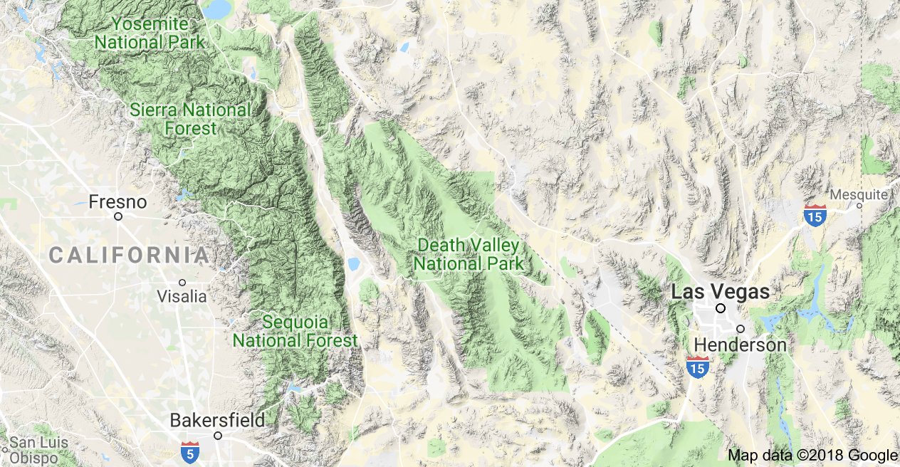
Fig 1 Topographic map of Inyo County

That got me thinking, what other geologic complex does this county have? Like how did these mountain ranges or these deep valleys formed? Are there frequent earthquakes here? Has any faults formed because of it?  Can I tell how old the rocks are?

To find out about how theses mountain ranges formed, like the Inyo Mountains, using a geologic map can help me find what type of rocks and faults were found on that mountain. It is useful to help me find the different types of rocks that have formed in the Inyo county and it can also tell me the location of geological structures such as faults and fold if there are any in Inyo County. Also knowing some lithology is helpful because it can help me identify the different types of rocks I encounter when I go see the rock formations in Inyo. Studying lithology will help me with relative dating. If I am studying these rocks formation I also want to know which rocks are older and which ones are younger. Using the principles that helps me with relative dating like superposition, original horizontality, cross-cutting, etc, will give me an insight of how the rocks formation came to be.

Fig 2 Geological Map of Inyo County

Knowing the rock formation dating all the way back to the complex Paleozoic and Mesozoic tectonics evolution of the southwestern United States and Fig 2.  tells us the history of the geological history during which the continental margin of the western United States gradually changing from a passive tectonic setting in the early and middle Paleozoic to an active tectonic setting in the Jurassic and Cretaceous. I would also be interested in learning about the fossils that would be imbedded into some of these rocks. I would have examine the fossil evidence and use relative dating to see where the rocks lies on the geological time scale.

Sources:
Figure 2f from: Irimia R, Gottschling M (2016) Taxonomic revision of Rochefortia Sw. (Ehretiaceae, Boraginales). Biodiversity Data Journal 4: E7720.
Figure 2f from: Irimia R, Gottschling M (2016) Taxonomic revision of Rochefortia Sw.    (Ehretiaceae, Boraginales). Biodiversity Data Journal 4: E7720.
Stone, P., Swanson, B. J., Stevens, C. H., Dunne, G. C., & Priest, S. S. (n.d.). Geologic Map of the Southern Inyo Mountains and Vicinity, Inyo County, California.

Week 6 - Geology in CA


The area that I choose to explore is surrounded by many different types of rock from many different slots in time. In the middle you have sediment that contains shale and limestone from the Triassic age. Just to the right you have volcanic rock from the Tertiary age. Just to the bottom is sandstone and shale from the Miocene age. Finally, to the south west is shale, limestone, and slate from the Jurassic age.

While much of the area is green and covered up by plant life there is much history below the surface. With a bit of work there is a lot to discover.

Upon looking at information on faults near by it doesn’t seem like it is right on top of any faults, but an earthquake might very well cause layers to shift in interesting ways. Given that California is pretty famous for earthquakes I would have thought of that anyways.

The three things I would want to request more information on would be if faults are able to affect the area and what earthquakes have happened nearby. The second item to find out more about would be where the major plates are and how they interact with the area. Lastly would be the weather that happens yearly and the extreme weather events that occur sporadically. I imagine that would be the three major things that would have effected the area the most.

Source: https://maps.conservation.ca.gov/cgs/gmc/
Source: https://maps.conservation.ca.gov/cgs/fam/
Source: Google Maps

Tuesday, November 27, 2018

Week 6 - Geological Interpretations - Taylor Mills

Figure 1. Geologic map of San Bernardino County, California (Morton & Matti, 2001).
Figure 2. San Bernardino physiographic provinces map (Morton & Miller, 2006).
Recently, I had the pleasure of visiting San Bernardino County, California.  A quick look at the county's geologic map (Figure 1) illustrates its array of geological complexities.  During my visit, I recognized the county's highly diverse geologic and physical features.  As evidenced in Figure 2, San Bernardino County is home to the Peninsular Ranges, Transverse Ranges, and the Mojave Desert.  Depicted in Figure 3, San Bernardino County also includes the San Gabriel Mountains, San Bernardino Mountains, Mill Creek, and the Peninsular Ranges assemblages which are all basement rock assemblages.  Furthermore, geologic forces such as bounding and falling (landslides of rocks and/or other material/debris) of said basement rock assemblages occurred as a result of the area's several seismically active fault zones.  These zones include the San Andreas, San Jacinto, Elsinore, Whittier, Cucamonga, and Sierra Madre Faults and are all depicted in Figure 3 as well.  Moreover, the county includes various types of rocks from the Pleistocene-Holocene age which are Quaternary deposits (i.e. alluvium, lake, playa, terrace deposits, etc.).
Figure 3. Location of San Bernardino's geologic and physical features (Morton & Miller, 2006).
Although I enjoyed visiting San Bernardino County, California, there are several pieces of information I would request in order to properly study the area.  First, I would prefer information regarding the county's seismic activity to understand just how active its faults are and how they might have impacted the modern-day county's landscape and composition.  For this reason, I also think it would be helpful to have some sort of aerial footage of the area, specifically the areas near the county's faults, to see the landscape's change over time and sediment deposits since these deposits are important in understanding its geologic time.  And, in line with geologic time, I would like some record of the county's fossils to not only understand previous life forms, but also previous environmental conditions and a more accurate time indicator for the rocks' ages.

Monday, November 26, 2018

Week 5, Mariana Trench


This week I took a trip to see the Mariana Trench.  While there may be little to see on the surface of the ocean, to humans, this location is one of the most dangerous in the world.  Just like it is one of the most volatile places as the Pacific plate is actively subducting beneath the Philippine/Mariana plate.

There are enormous stresses occurring at and around this location.  Nearby the Philippine/Mariana plate is experiencing compressional stress from the subduction.  This has in turn folded the ocean floor and part of these anticlines has created the Mariana island chain which Guam is a part of.  The trench itself is subjected to shearing stress as the Pacific plate moves under its companion tectonic place.  The western edge of this Pacific plate is comprised of some of the oldest crust on earth, making this particular part of the plate cooler and comprised of harder rock.  While some of the rock is brittle, this unstable area is also home to both heat and pressure.  The bottom of the trench is often a source of lava and is more prone to ductile deformation.  It is a geological hot spot in more way than one.

While this visit is fascinating from a scientific perspective is not a location for the faint of heart.


Sunday, November 25, 2018

Week 5 - Convergent Plates that Formed the Cascade Range


This week I visited the Cascade Range in Northern America, which extends from South Western Canada through the North Western US into California. The mountains are formed by the converging force of the Pacific and North American plates. The stress produced by the subduction of the Pacific plate compresses the North American plate side and uplifts the area into the mountain ranges that are present now.

Source: https://www.bpa.gov/news/newsroom/Pages/BPAs-participation-in-Cascadia-Rising-exercise-featured-in-NWPPA-Bulletin.aspx
As is typical of dip-slip faults, the friction and resulting heat create volcanoes that form in a parallel line to the fault. The Cascade Range is home to several well-known volcanoes, such as Mount St. Helena, Mount Rainier and several others. These fault lines are reverse or thrust faults, since the stress is a compression force. Faults are the dominant stress feature across the Range.


Cascade Range
 (Click image to view full size.)
Source: https://volcanoes.usgs.gov/observatories/cvo/cascade_volcanoes.html
Along the mountain range, new rock is being formed through volcanic activity. This igneous rock is deposited by volcanoes and vents, which then cools to harden and form new rocks. The subduction activity also acts to uplift the Cascade Range, slowly raising it from the surrounding plate. Nearer to the fault line, the action of the subducting Pacific plate sliding under the North American plate deposits rock along the fault, called the accretionary wedge. This formed the Upper Western US and is composed of rock that once composed the bottom of the Pacific Ocean.


Week 5 - Converging Plates - Andes Mountains

Converging plate occur when one plate begins to go under another plate. It can be oceanic and continental plates, oceanic and oceanic plates, or continental and continental plates that come together with one going under the other. Whenever oceanic crust meets continental crust the oceanic crust goes below the continental crust since the oceanic crust is more dense.

This week I choose to look at the Andes Mountains. This mountain range was formed by the ocean crust that is called the Nazca Plate going under South America. As it did it pushed the higher layer crust together to form the mountains. Interestingly enough, while the mountains were formed millions of years ago, much of the rock in this area is hundreds of millions of years old.


Sources

http://learner.org/vod/vod_window.html?pid=317
http://mountain.org/andes-mountains/
https://www.britannica.com/place/Andes-Mountains
https://en.wikipedia.org/wiki/Nazca_Plate#/media/File:NazcaPlate.png

The Andes Mountains


The Andes Mountains


After the pilot was done giving us instructions on how to settle in the helicopter, we were set and ready to go.  Once the helicopter took off it seemed like only a few moments before we were able to reach our destination.  The Andes Mountains spanning through seven South American countries is 4,300 miles long and has an average height of about 13,000 feet, was an amazing site to see.  Who would have thought that this was all created by the compressive stress of the Nazca Oceanic Plate as it is subducted under the South American Continental Plate.  It was easy to see all the andesite and diorite rocks since both are very common above subduction areas.  Both of these volcanic rock types have a similar composition to basalt and granite due to the melting of the basaltic ocean plate.  The Andes are known for being fold mountains since the plates had been pushed together.  As the plates collided and the land came together it caused folding to occur where landmass is pushed forming entire mountain ranges.  We also noticed the reverse faults of the Andes Mountains that were caused due to the compression of plates.  A reverse fault happens when crust of one block slides on top of the other, these are common to compression zones. I will never forget such an incredible trip to the Andes Mountains it was definitely worth the long flight to get there.

References:
https://en.wikipedia.org/wiki/Andes

Week 5- Mount Everest


Mount Everest is a highly popular destination for avid hikers and adrenaline seekers. I have never been to the European or Asian continents. So, one day I decided to pack my bags and visit this destination. Did I dare trek up the mountain to experience what few have been able to do so? I wasn’t sure, but I knew seeing this massive structure that was formed millions of years ago in person would be great to experience.
When I got to the destination, I learned a lot about the beautiful geologic creation in front of me. Before there were separate continents, there existed a super continent known as Pangea. This was about 250 million years ago. Eventually the continents separated and formed new continent’s collision zones.
About 70 million years ago, two plates began motion to form Mount Everest. The Indo-Australian Plate moved northwards to the Eurasian Plate. The plate was moving rapidly at about 15cm per year. Eventually the collision of these two plates created Everest. While there I learned that the Mount is not done growing. It’s believed the Indian Plate is moving towards the Tibetan Plateau and is causing Mount Everest to continue growing.
It’s amazing how our planet is not still and continues to grow and reshape itself. As I explored the base of the mountain, I found different kinds of rocks. This made me inquire to the locals about what kind of sedimentary rock layers could be found throughout Everest. I learned that limestone, marble, granite, gneiss, and pelite can be found there. Mount Everest is also divided into three formations. They are the Rongbuk Formation, the North Col Formation, and the Qomolangma Formation. Each formation carries different rocks and minerals.


Image result for Mount Everest

Image result for Mount Everest rocks

Source

Week 5 Converging Plates: The Aleutian Trench

Image credit: NASA


For this week’s travel post, I chose to write about a convergent-plate margin located at the North end of the Pacific ocean, between Alaska and Russia. This margin is known as the Aleutian Trench, and is home to a multitude of significant crustal deformations. The tectonic activity occurring at this convergence zone is subduction, with the oceanic Pacific Plate sliding underneath the continental North American Plate. A significant oceanic trench has formed along this subduction zone, and is over 2,000 miles long and 26,000 feet deep. 

The Aleutian Trench is home to a series of major thrust faults, which are collectively identified as the Alaska-Aleutian Megathrust fault. The compression forces along these faults have been responsible for some of North America’s most significant earthquakes. In fact, the Alaska-Aleutian Megathrust fault has been responsible for 9 out of 10 of the largest earthquakes ever measured in the U.S., with the 1964 Alaska earthquake being the largest.

Convergence of the North American and Pacific tectonic plates is responsible for more than just trenches and faults in this area. During the subduction process at this convergence zone, the Pacific Plate descends into the mantle, melts, and subsequently rises parallel to the Aleutian Trench. Over time, this accumulation of magma near the surface has led to the formation of a long chain of small islands called the Aleutian islands. This island chain consists of 14 large active volcanoes and 55 smaller ones, and is part of the famous “ring of fire” chain of active volcanoes in the Pacific ocean.

It is amazing to see such significant evidence of tectonic plate activity in one area! Between the deep trench along the subduction zone, the chain of active volcanoes on the continental side, and the intense seismic activity, there is no question that this geographic location is a convergent-plate boundary.