Sunday, May 31, 2020
Week 2, Igneous Rocks
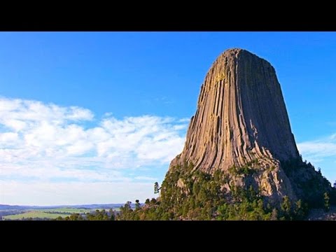
My brother and I decided it was time to take a trip to Devils Tower. It is a national monument in Wyoming that is pretty much a gigantic tree stump made of igneous rock. It is absolutely amazing to see what it looks like up close and how insanely tall it stands. Pictures cannot describe the experience we had when we were there but we will try to do our best. If these do not make you think of a giant tree stump, then I do not know what will. But it is so sturdy that people were climbing it while we stood at the bottom in awe. I hope you enjoy this picture.
Snake River, Week 3
Snake River, Where I decided to visit for my trip this week. It's based out of the Yellowstone national park. It was given it's name around 1812 which is one of the oldest names in the park, and was given to them by the Shoshone Indians. Shoshone Indians referred to some of the streams as "Yampa-pah" which means where it grows. Yampa, is a plant that was eaten during the Oregon Trail days.This river is the 4th largest in the nation and covers about 42 miles just in the Yellowstone National Park.
Week 4 Volcanoes
Unlike most volcanoes that go up from the ground slowly, this volcano is almost perfectly standing straight up like a tree trunk. When visiting here I also have noticed the wild life, animals, flowers, and even the snow top which I was told is year round! It is an amazing place to be and on the list of places to come back to for me.
Volcano

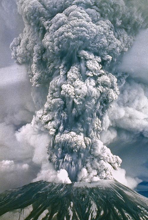
This week for the travel journal I visited Mount Saint
Helens which is a volcanic peak in the Cascade Range of southwestern Washington.
It erupted on May 18, 1980 and was one of the greatest volcanic explosions ever
recorded in North America. It was an explosive volcano and killed 57 people. It
is labeled as a “composite volcano” meaning it is steep-sided and has
alternating layers of lava flows, ash, and other debris. It is comprised of
andesitic and rhyolitic pyroclastic materials. I believe that Helens will erupt
again. The average eruption occurrence is every 100-300 years. The exact timing
of the next eruption can not be forecasted at this time. It is interesting that
this eruption was the most deadly and economically destructive volcanic event
in the history of the US.
Week 4 - Volcano
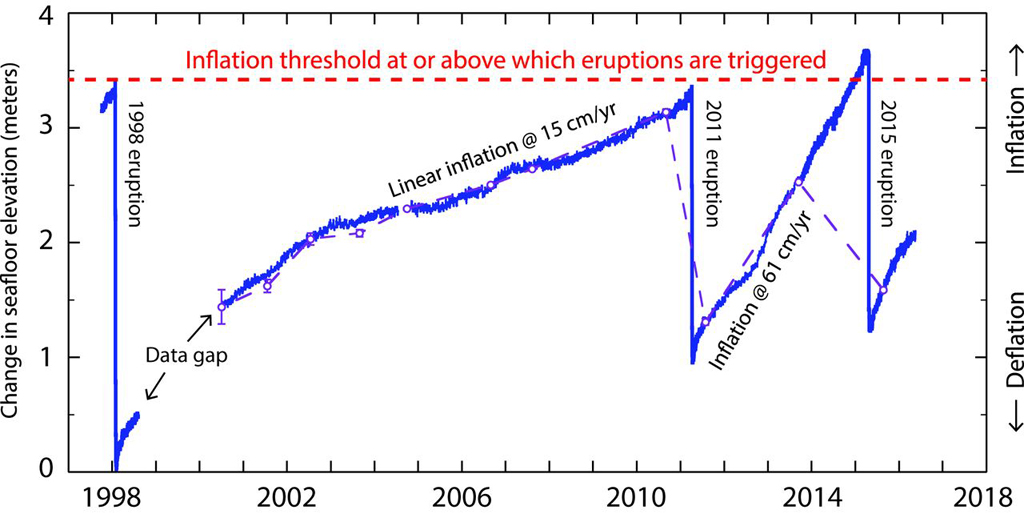
This week I was able to tour Axial Seamount. A seamount is an underwater volcano. Axial is located on the Juan de Fuca ridge about 298 miles west of Oregon. It rises 3,906 ft. above the ocean floor and the summit 4,626 ft. below sea level.


https://upload.wikimedia.org/wikipedia/commons/thumb/0/0a/Axial_Exaggerated_Bathymetry.jpg/1280px-Axial_Exaggerated_Bathymetry.jpg
Even with the mixed reviews from google maps I found this trip quite interesting. It is currently the most active among the Cobb–Eickelberg Seamount chain and sits on top of the Cobb hotspot. Axial is defined by its unusual rectangular-shaped caldera breached to the south-east. Around the breach there are hydrothermal vents and biological communities.
https://scx1.b-cdn.net/csz/news/800/2011/oceanobserva.jpg
Axial has erupted a few times, in 1998, 2011, and 2016. This is the easiest volcano to predict due to the thin crust and lava pressure. There are monitors on the sea floor that measure vertical distance. This shows the volcano inflating until it erupts then deflating. due to this close monitoring, it is the only submarine eruption to be observed throughout the whole cycle.
https://volcano.si.edu/images/bulletin/331021/331021_BGVN_017.jpg
Saturday, May 30, 2020
Volcanoes Week 4
This week we visited Mount Rainier which is located southeast of Seattle Washington in Mount Rainier National Park. This volcano is composite and considered to be one of the most dangerous in the world. Its location is because of the subduction of the Juan de Fuca Plate off the western coast of North America. It is apparent we can see the signs of build up from previous lava and loose rubble from its tall cone .
This volcano is considered an active stratovolcano. Although it has been dormant for approximately 150 years it shows signs of possible eruption in the coming years. Considering these signs, there are hazard concerns for the people living in this area. Due to the explosiveness and enormity of eruption that can occur from Mount Rainier, potentially 80,000 people are believed to be in harms way.
Although this volcano is considered geologically young at about 1 million years old it is about 14,410 feet high. It has formed from eruptions and andesite lava flows over this period of time. When visiting and looking at the detail of the flows (pictured below) it is absolutely beautiful. What an absolutely amazing piece of earth! Lets hope it doesn't erupt any time soon.
 Source: https://www.britannica.com/place/Mount-Rainier

This volcano is considered an active stratovolcano. Although it has been dormant for approximately 150 years it shows signs of possible eruption in the coming years. Considering these signs, there are hazard concerns for the people living in this area. Due to the explosiveness and enormity of eruption that can occur from Mount Rainier, potentially 80,000 people are believed to be in harms way.
Although this volcano is considered geologically young at about 1 million years old it is about 14,410 feet high. It has formed from eruptions and andesite lava flows over this period of time. When visiting and looking at the detail of the flows (pictured below) it is absolutely beautiful. What an absolutely amazing piece of earth! Lets hope it doesn't erupt any time soon.

Friday, May 29, 2020
Vocanoes - Volcan de Fuego Guatemala
Volcan de Fuego, Guatemala
I visited Guatemala and hiked the Volcan Acatenango to see the consistently erupting Volcan de Fuego (twin to Acatenango). This composite volcano frequently erupts mildly while explosive eruptions are more rare. Still, explosive eruptions have happened enough for Volcan de Fuego to be considered frequently erupting.
Because Volcan de Fuego is a composite volcano or stratovolcano, it is steep and conical. It is known to have mild explosive activity, but intense lava fountains have also been reported.
Volcan de Fuego is dangerous because of pyroclastic flow and lahars. Actual lava flow is slow moving and less of a threat to people. This is what helps build the steep sides of the volcano. Pyroclastic flow from Volcan de Fuego is very hot and fast moving gases, ash, and volcanic material which races down the volcano taking anything out in its path. Lahars, mudslides consisting of water and volcanic ash are typical to eruptions of Volcan de Fuego considering the wet environment and proximity to the coast.
Volcan de Fuego is part of a volcanic chain formed along the Caribbean Plate tectonic boundary. This chain, along with many others around the world is part of the Ring of Fire. This is caused by a subduction zone or convergent boundary. The oceanic plate called the Cocos Plate is drawn under the continental plate called the Caribbean Plate. the converging of these plates causes pressure changes inside the volcano. When silica-rich magma and gases build up inside the magma chamber, they eventually explode suddenly.

Constant gas erupting from Volcan de Fuego

Hiking Volcan Acatenango next to Volcan de Fuego


Tuesday, May 26, 2020
Week 4 - Volcanoes
In visiting the state of Washington, it was of the upmost importance to ensure I stop in Cougar and travel 11 miles outside the city to gaze upon the wonder that is Mount St. Helens. I remember building a model volcano for a science fair project back in middle school, so it was a perfect way to venture down a nostalgic, memory lane in pursuit of my childhood happiness. Upon hiring a tour guide, he advised during our journey that this volcano is an active composite volcano, which means it was built up by many layers of hardened lava, pumice and ash from previous intervals of explosive and effusive eruptions. Because it was built up over time, Mount St. Helens possesses a steep profile with a summit crater; the lava flowing from this stratovolcano cooled and harden before it could spread far due to the lava's high viscosity. As we arrived at the base of the volcano's location in the Cascades Range, the tour guide informed me that Mount St. Helens is a result of the ongoing subduction of the Juan de Fuca tectonic plate beneath the western coast of North America, and has taken approximately 40,000 years to become the behemoth volcano it is today. As we drew nearer to the summit, it was interesting to see the larger, rounded rock formations from the previous lava flows, which appeared to be layered and stacked on each other like clouds from the lava cooling and flowing in a unique cycle. I began to contemplate just how devastating the damage was from the 1980 eruption, spewing ash and gas up to 15 miles high while also decimating 135 square miles of forest. I recalled how the visitor's center information boards mentioned it killed 57 people and was the deadliest eruption in U.S. history. Standing at the summit, I felt alive standing on top the active volcano knowing that is still one of the most dangerous in the United States. As we traveled back down the side of this sleeping giant, I asked the tour guide what the chances were of it erupting again. The guide enlightened me, saying that the rough time interval between eruptions was every 100-300 years but that it's unlikely its eruption will have any effect on other surrounding volcanoes erupting. I gained a great respect for Mother Nature on this part of my trip, but did so with a smile as I finally got to witness a real volcano for the first time since being 15 years old.
Source: https://tdn.com/mount_st_helens/tdn-veteran-editor-to-join-look-back-on-eruption-of-mount-st-helens/article_430dd775-54c0-55c9-b35a-68fc129200ae.html
Source: https://tdn.com/mount_st_helens/tdn-veteran-editor-to-join-look-back-on-eruption-of-mount-st-helens/article_430dd775-54c0-55c9-b35a-68fc129200ae.html
Week 3 - Rivers
Although I have visited the location very often, it's intriguing to observe and study how our family farmland is affected by the perennial Missouri River which flows from the West to East, as well as right next to our fields. Depending on the weather, every visit down to our bottoms is diverse as the water level decreased or increases based on rainfall and other numerous factors. Although there are no sandbars near this part of the Missouri River, they do stretch out in numerous areas where the water levels are below 7-8 feet, making it easier for the sediment to collect and create elevated beds of white sand. Our crops are protected by an artificial levy my deceased grandfather built, which also helps ensure that our land isn't turned into a flood plain and keeps the soil nutrient rich, but it also has its faults. In the case of this past year (2019), the Midwest received a great deal of precipitation and caused a mass flooding of the area. In our case, our levy had a hole punched in it due to the high than usual discharge (velocity) of the meandering Missouri River and the water hitting the bends of the river which happens to be where our farm land is positioned. Typically, the river flows faster than normal due to its high surface area (wide channel) and the fact it flows over mud/clay, creating less resistance. Although, it's amazing to think that even though rivers only contain 1/4 of the Earth's annual precipitation, the high discharge (which is not usual for this part of the Missouri) was caused by high rain levels and other sources of water being dumped into the Missouri River from other areas such as Nebraska and Iowa. As a result, we not only had to fill the hole in the levy once the water levels decreased, but we couldn't plant crops in the spring because we had to wait for the sitting water to evaporate; we have a drainage system in the corner of our land for excess water to drain into the Missouri River, but it doesn't help with sitting water in the middle of the plain. An enormous blessing was that in the slow evaporation of the river water, the soil became more nutrient rich than usual. Thankfully, insurance companies offered financial assistance to my family and many others farmers across the Midwest.

Atop the bluff over-looking our bottoms nesting next to the Missouri River during the flood of 2019.
Photo Credit: William Irvin-Linneman

Standing on top our artificial levy, observing the mass flooding of our fields during the flood of 2019.
Photo Credit: William Irvin-Linneman
Sunday, May 24, 2020
Moraine Park, CO - Glaciers
This weekend, I visited Rocky Mountain National Park in Estes Park, CO. I spent the night at Moraine Park Campground. Moraine Park is a large U-shaped valley formed by a valley glacier during the Great Ice Age about 2.5 million years ago. The sides of this mass valley include giant boulders deposited by the glacier forming lateral moraines. Along the flat ground many other boulders remain as ground moraine, while at the end lies a large terminal moraine. The large open valley of Moraine Park was this ancient glacier’s zone of wastage. Here, the ice would begin to melt, depositing a lot of debris. The lateral moraines consist of straited, polished rock, rather than the brittle crummy rock untouched by glacial erosion in other parts of the national park. From the mass valley, I hiked the Cub Lake Trail to Cub Lake which contains an abundance of till and seems to be in a cirque-like gorge formed by the glacier. Please see the attached birds-eye pictures of the area. You can see the way that this large mass of ice formed the U-shaped valley, leaving behind lateral moraines, medial moraines, ground moraine, and end moraines as well as a large open valley where the snout of the glacier resided and the ice finally melted.

Moraine Park - U-shaped valley formed by glacial erosion

Till at Cub Lake


Week 3 - Running water
Rubicon river Eldorado County, CA


On day 2 of the Jeep Jamboree trip of the Rubicon trail consisted of vehicle maintenance and a little bit of swimming. The vehicles and campsite were at Rubicon springs right next to the Rubicon river.
https://i.ytimg.com/vi/AnGWUOEQF-o/hqdefault.jpg
The Rubicon river is a drain for the western flank of the Sierra Nevada. Starting at an elevation of 8700 ft, it runs about 60 miles mostly running NNW and has a watershed of about 184 sq. mi. It carves it way through the granite rocks creating a valley 58 ft deep in some areas. by doing this it started showing some of the layers that make up the mountain range.

The river used to meander in the valley until it was diverted for hydroelectric dams. On December 23rd, 1964, the river flowing at max discharge. The surge wave carrying Alluvial deposits, of both Pleistocene and Recent
age, colluvium, including material from landslides
triggered by the surge, soil, and bedrock, broke the Hell Hole dam.
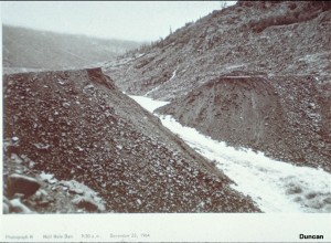

https://research.engineering.ucdavis.edu/gpa/wp-content/uploads/sites/43/2015/02/Failure-of-Hell-Hole-Dam-P03-300x220.jpg
https://upload.wikimedia.org/wikipedia/commons/thumb/9/92/Rubicon_River_flowing_through_cataract_to_Hell_Hole_Reservoir.jpg/603px-Rubicon_River_flowing_through_cataract_to_Hell_Hole_Reservoir.jpg
Gobi Desert
This week I am visiting the Gobi desert which is a vast,
arid region in northern China and southern Mongolia. It is known for its dunes
and mountains. The Gobi desert is a rain shadow desert, formed by the Tibetan
Plateau blocking precipitation from the Indian Ocean reaching the Gobi
territory. When I look around, I see the desert is vast and surrounded by Mongolian
grasslands and Altai mountains. To the west, the Gobi desert is surrounded by
the Taklamakan Desert. The Gobi desert is locked inside a land mass. It is an
overall cold desert, with frost and occasionally snow occurring on its dunes.
It can be cold because it is elevated far above sea level due to its proximity
to the Himalayan Mountains. It is composed of sediment from erosion of the
volcanic rocks such as granite, basalt and rhyolite as well as from ocean
sediments. Some animals that live here
are the snow leopard and the wild Bactrian camel.

Friday, May 22, 2020
Week 3 Glaciers
Gorner Glacier - Switzerland

Image Source: https://www.gornergratbahn.ch/fileadmin/_processed_/8/b/csm_gornergletscher-zermatt-gletscher_1417d16aff.jpg
I visited the Gorner Glacier in Switzerland this week. What an absolutely amazing site. The Gorner Glacier is the third largest glacier in the Alps. It is approximately 8 miles long and 0.8 miles wide. Given that this glacier has formed high upon the mountains and move downward through the valleys, that would make it an alpine glacier (a.k.a valley glacier).
Typically with alpine glaciers, sediments are deposited. Moraine sediments of till are deposited by the Gorner Glacier. It is pretty amazing how this glacier flows through the mountain and follows the direction of the valley as it moves towards the bottom. The below picture has a better view of the sediment and the path flow of the glacier.

Credit : Larry Naess https://www.flickr.com/photos/137821517@N07/42549597830
One thing that is important to note is that this glacier is also classified as a retreating glacier. This is due its reduction is size consistently year after year. Recent estimates confirm this glacier loses around 100 feet per year and has lost a total 8,200 ft. since 1859.
Sunday, May 17, 2020
St. Francois Mountains, MO - Igneous Rock Formations
When I was a child, I visit the St. Francois Mountain located in the south-eastern portion of Missouri.
I recall the many formations towering over me, most likely due to my size and nature as a kid! These extrusive igneous formations are indicators that even volcanic eruptions can have have an affect where no volcanoes exist presently. I remember learning how two iconic minerals, iron and granite, were mined from these mountains and how the locals still mine them to this day. The intrusive granite was cooled slowly over time underground and had enough time to develop crystals of quartz, feldspar and mica. However, most of the topical formations consist of rhyolite, a brown, igneous rock that consists of the same chemical and mineral composition as granite but was formed from magma cooling rapidly as a result of a volcanic eruption. There was little red granite visible, and it was awesome to feel the sense of discovery as a kid when I saw the crystals glitter in the sun, especially since the rhyolite didn't have any visible crystal. Nostalgia is getting the best of me, and I feel I may have to make a return as a young adult to get the same sensation again!

Saturday, May 16, 2020
Cabo San Lucas Granite - Intrusive Igneous Rock
A year and a half ago, my daughters and I visited Cabo San Lucas in Mexico with my brothers and parents. While walking along the beach, we noticed large rocks protruding from the shore. The rocks were beautiful, and upon examination we could tell that they were granite. These granite rocks must have formed underground considering the crystals in them. This type of igneous rock is considered intrusive as it forms underground. Since it forms under the ground, it cools very slowly allowing time for a lot crystals to form. This created the beautiful granite we saw on our lovely walks along the beach. The granite is now above the Earth’s surface due to shifting tectonic plates. This process took about 25 million years. Check out the pictures below!


Friday, May 15, 2020
The Rubicon Trail - Pollock Pines, CA - Igneous Rocks
On August 8th-11th, 2019 I joined Jeep Jamboree USA to take on The Rubicon Trail. Its a 17.
1 mile long jeep trail that winds through both private and public lands of El Dorado County.
Day 1:
We started off at the trailhead at loon lake where everyone aired down their tires and prepped for the next 3 days at 1 mph. We set off, passing by possibly one of the most photographed trail signs.


1 mile long jeep trail that winds through both private and public lands of El Dorado County.
Day 1:
We started off at the trailhead at loon lake where everyone aired down their tires and prepped for the next 3 days at 1 mph. We set off, passing by possibly one of the most photographed trail signs.
https://jeepjamboreeusa.com/wp-content/uploads/2018/11/rubicon1.jpg
From there we arrived at where the gatekeeper used to stand. It got its name because it kept people and vehicles out that would not be able to complete the trail. It was unfortunately demolished in 2004. Once passed that we made our way into the Granite Bowl.
https://s3.us-west-2.amazonaws.com/images-prod.trailsoffroad.com/trails/1029/waypoints/1/20160702_112606.jpg
This massive open area is nothing but slick exposed granite that was un earthed buy glaciers moving and scraping all the volcanic rock that covered it. We journeyed down into the bowl then back up The Steps on the other side.
https://www.fourwheeler.com/uploads/sites/3/2019/09/001-rubicon-trail-modern-jeeper-adventures-metal-cloak-2019-stuart-bourdon.jpg?fit=around%7C875:492
We kept moving along at our very exiting snails place past an ample amount of various difficult obstacles. Past Ellis Creek Bridge, up Walker hill. and finally to The Soup Bowl. Made up of 2 ledges, each over 5 ft tall it was a challenge to everyone.
https://s3.us-west-2.amazonaws.com/images-prod.trailsoffroad.com/trails/1029/waypoints/1/20160702_151434.jpg
From there we make our way onto the landmark piece of the trail, Little Sluice. Little Sluice is the definition of rock garden, made up of small sedimentary rock and granite. It used to have much larger rocks but were broken down by the forest service to make this part passible.
https://s3.us-west-2.amazonaws.com/images-prod.trailsoffroad.com/trails/1029/waypoints/2/20160702_154243.jpg
The rest of the day was just as grueling as the beginning passing our way through more obstacles like:
Squeeze
https://www.fourwheeler.com/uploads/sites/3/2019/09/048-rubicon-trail-modern-jeeper-adventures-metal-cloak-2019-stuart-bourdon.jpg?fit=around%7C875:492
Arnolds Rock
https://s3.us-west-2.amazonaws.com/images-prod.trailsoffroad.com/trails/1029/waypoints/0/20160702_162116.jpg
The Big Sluice
https://s3.us-west-2.amazonaws.com/images-prod.trailsoffroad.com/trails/1029/waypoints/1/20160702_184259.jpg
Saw Tooth
https://s3.us-west-2.amazonaws.com/images-prod.trailsoffroad.com/trails/1029/waypoints/1/20160702_184718.jpg
We finally make it to The bridge that will take us into Rubicon Springs and where we will camp for the night. Day 2 was spent at Rubicon Springs where we swam, relaxed, and repaired the damage the trail had done the previous day.
https://s3.us-west-2.amazonaws.com/images-prod.trailsoffroad.com/trails/1029/waypoints/0/20160702_200016.jpg
https://www.fourwheeler.com/uploads/sites/3/2019/09/008-rubicon-trail-modern-jeeper-adventures-metal-cloak-2019-stuart-bourdon.jpg?fit=around%7C875:492
The Rubicon Trail (https://www.trailsoffroad.com/trails/1029-the-rubicon-trail)
Rubicon Trail (https://www.atvescape.com/the-directory/trails-and-tracks/california/rubicon-trail?cat_id=105)
A New Way To Rubicon (https://www.fourwheeler.com/events/1909-new-way-rubicon/)
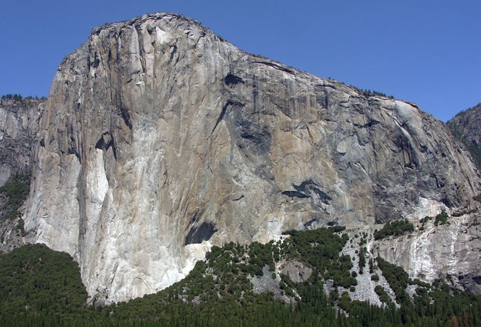
Yosemite National Park - Igneous Rocks
I visited Yosemite National Park with my brother Jason and
(to be) sister in law Kelly. Yosemite is made up of the interaction of glaciers
and the underlying rocks. Granite dominates the Yosemite area and much of the
Sierra Nevada as well. Granite is a type of light-colored igneous rock. I can
see the grains in the rock because they are visible to the unaided eye. Granite
is composed mainly of quartz and feldspar, with minor amounts of mica, amphiboles,
and other minerals. Many of the high peaks and cliffs at Yosemite are granite
and more than 100 million years old. Most of Yosemite is comprised of plutonic igneous
rocks which means they form deep underground when molten rock cools and
solidifies very slowly, allowing large crystals to form. Attached is a picture
of Jason and Kelly on top of Half Dome which is made up of granite, after they
got engaged. (picture is real, they actually got engaged there 😊)

Wednesday, May 13, 2020
Bandelier National Monument Los Alamos, New Mexico Igneous Rocks
I visited the Bandelier National Monument in Los Alamos, New Mexico. Due to its preserved Pueblo Indian history, ancient ruins, cave dwellings, deep canyons and volcanic mountains, this historical monument is a hot bed for geological exploration. Standing in front of the pictured cave is certainly enough for anyone to wish to gaze inside.
 Image Source : https://www.americansouthwest.net/new_mexico/bandelier/national_monument.html
The monument is located on the slopes of the Jemez volcanic field. This allows visitors the opportunity to see the igneous rocks which were formed from the molten materials which have been cooled and solidified. This resulted into the obsidian rocks which can be found on the north west side of the park and is pictured below. The obsidian rock was formed from the molten lava which cooled very quickly. Essentially this gives the rocks a smooth texture and a glossy appearance.
 Image Source: https://www.nps.gov/band/learn/nature/obsidian.htm
Due to the high quality of the obsidian used from the Jemez mountains, the indigenous used these igneous rocks to make sharp pointed objects. Based on the physical characteristics of obsidian and its hardness values, it also made the rock perfect for making tools.

Image Source: https://www.nps.gov/band/learn/historyculture/trade.htm
The trip to Bandelier National Monument was one to remember. Given its great Indian history and exponential amount of geological exploration, I would love to visit again someday when I have more time.

The monument is located on the slopes of the Jemez volcanic field. This allows visitors the opportunity to see the igneous rocks which were formed from the molten materials which have been cooled and solidified. This resulted into the obsidian rocks which can be found on the north west side of the park and is pictured below. The obsidian rock was formed from the molten lava which cooled very quickly. Essentially this gives the rocks a smooth texture and a glossy appearance.

Due to the high quality of the obsidian used from the Jemez mountains, the indigenous used these igneous rocks to make sharp pointed objects. Based on the physical characteristics of obsidian and its hardness values, it also made the rock perfect for making tools.

Image Source: https://www.nps.gov/band/learn/historyculture/trade.htm
The trip to Bandelier National Monument was one to remember. Given its great Indian history and exponential amount of geological exploration, I would love to visit again someday when I have more time.
Saturday, May 9, 2020
Wednesday, May 6, 2020
Tuesday, May 5, 2020
Sunday, May 3, 2020
Week 8 - Alexis Torrez - Global Warming
It is 7010, and during this trip to the future I have decided to visit Hudson Bay, located in Canada. At this time, the Earth has rebounded more than 650 feet back to it's original position. There is very little gravity here due to Earth being pushed to the sides from ice sheets.

Source : planetware.com
This was Hudson Bay 5,000 years ago. Today, the land has been re-shaped and shifted. The mountains are much higher. Our global society did nothing in changing their ways through global warming. Changes in sea level occurred faster than it would have if taken it's natural course. When the sea levels began to raise drastically, this lead to more natural disasters. Society's numbers lowered some, and others were forced to learn a new way of life in newer areas toward the center of the continents. Society has now evolved back to some of it's natural ways of the hunter-gathering era. Although there is advanced technology, it is used to enhance travel and hunting. Geologist have discovered more patterns of the earth after a small ice age era has passed. After learning that the industrial era was devastating to our earth, humans have learned to use other resources for their daily living needs.
Week8 - Kyle Quirk - L.A. in 7020
This week I traveled 5000 years in the future to Los Angeles, California. I assumed that humanity as a whole would continue on its destructive path and there wouldn't be much of L.A. to take in. However, I found that we were able to turn around our destructive behaviors and start using more environmentally friendly resources for transportation, sustaining life, and entertainment.
With the conversion of transportation to all electric or hydrogen powered vehicles, we've created less pollution. Products that previously used an oil-based plastic are now using biodegradable materials, producing less waste to be buried in landfills. Manufacturing plants have found a way to reuse the carbon emissions they produce, eliminating a major contributor to climate change.
The one thing that really stood out to me was the use of very high walls around coastal cities due to the rise of the sea level as the polar caps melted. Luckily, humanity was able to react quickly to the rising sea levels and change not only the way they lived but also build these sea walls that continue to let them live in beautiful coastal cities.
I'm just glad they were able to figure out the sea walls and the extreme carbon emissions cuts so we didn't end up with a coastal map that looked like this:

Week 2 - Matt Bulow - Igneous Rocks
This week I decided to head out to Yosemite National Park to get a good look at some igneous rocks, particularly granite rocks. Granite is an intrusive igneous rock. This means that it is formed from magma deep underground. Granite actually contains many different types of minerals such as quartz, feldspar, hornbende, and biotite. The proportions of these minerals can even change the name of the granite. These particular set of minerals will make up something called Granodiorite, which is still granite, just has a different name to show its composition. Fascinating right!? If not, then at the very least they are pretty to look at.
-Matt
Week 8 - Tracey P - Pearl Harbor, Hawaii
This week, I pulled a Jules Verne and went to the distant future; the year is 7020. Mankind has moved off to far away planets, colonized other worlds, and left only a small group of people on Earth, those that wished to stay instead of venturing into the stars. My time machine landed me on the island of Oahu, in the Hawaiian Island chain, far off what used to be "California."
Surprisingly, the people here seem to have reverted to the more Pacific Islander lifestyle that existed before the US annexed and added the islands as a state.
I convinced the locals that I was friendly, and was just here to learn. They were distrustful of me, but were willing to share the history as they knew it. Apparently, climate change was a bigger issue than anyone could have anticipated. Governments attempted to take more and more drastic action but citizens continued to push-back until it was too late. Multiple companies poured their research dollars into space exploration instead of combating the looming crisis. Once the technology became viable, countries spent money on sending dozens of exploration vessels out. Like the doves from Noah's Ark, they returned with nothing, or were never heard from again, until a single transmission was received; success!
First, thousands of people, with the money and desire to leave, bought private spacecraft and escaped their dying home. Later, as the ability to traverse the stars became more affordable, more and more people set off into the vastness of space, hoping to find their place in the cosmos. Those that chose to stay were left to fend for themselves on a planet supposedly in its death-throes.
But there was still hope! With so many people leaving and so much industry shut down, the planet finally began to heal. These islanders chose a simpler life, free of most technology. I took a day to survey the island I had landed on, finding a vastly different coastline than I had remembered from my past. While Pearl Harbor itself remained about the same, the spur of land where Hickam AFB once stood had been reclaimed by the sea. Also now underwater was much of Waikiki, downtown Honolulu, and the entire airport grounds.
All of Kailua was underwater as well. Waipahu was turned into an island in the harbor, much like Ford Island. The north shore destinations of Haleiwa and Waialua were also swallowed into the Pacific.
I thanked my hosts and headed back to my time machine, ready to return to my own time. If this future is the one set to come true, I'm only glad that I will not live to see such interesting times. As I punch i the digits for the date after I departed (to avoid any overlapping paradoxes and such), and just after I began the jump sequence, I noticed something amiss. My display was acting up again, and something was wrong with the date and time stamps of my destination! I would NOT be returning to 2020! Where will this blasted machine take me to this time?!
Surprisingly, the people here seem to have reverted to the more Pacific Islander lifestyle that existed before the US annexed and added the islands as a state.
I convinced the locals that I was friendly, and was just here to learn. They were distrustful of me, but were willing to share the history as they knew it. Apparently, climate change was a bigger issue than anyone could have anticipated. Governments attempted to take more and more drastic action but citizens continued to push-back until it was too late. Multiple companies poured their research dollars into space exploration instead of combating the looming crisis. Once the technology became viable, countries spent money on sending dozens of exploration vessels out. Like the doves from Noah's Ark, they returned with nothing, or were never heard from again, until a single transmission was received; success!
First, thousands of people, with the money and desire to leave, bought private spacecraft and escaped their dying home. Later, as the ability to traverse the stars became more affordable, more and more people set off into the vastness of space, hoping to find their place in the cosmos. Those that chose to stay were left to fend for themselves on a planet supposedly in its death-throes.
But there was still hope! With so many people leaving and so much industry shut down, the planet finally began to heal. These islanders chose a simpler life, free of most technology. I took a day to survey the island I had landed on, finding a vastly different coastline than I had remembered from my past. While Pearl Harbor itself remained about the same, the spur of land where Hickam AFB once stood had been reclaimed by the sea. Also now underwater was much of Waikiki, downtown Honolulu, and the entire airport grounds.
 |
| Map courtesy of NOAA |
All of Kailua was underwater as well. Waipahu was turned into an island in the harbor, much like Ford Island. The north shore destinations of Haleiwa and Waialua were also swallowed into the Pacific.
I thanked my hosts and headed back to my time machine, ready to return to my own time. If this future is the one set to come true, I'm only glad that I will not live to see such interesting times. As I punch i the digits for the date after I departed (to avoid any overlapping paradoxes and such), and just after I began the jump sequence, I noticed something amiss. My display was acting up again, and something was wrong with the date and time stamps of my destination! I would NOT be returning to 2020! Where will this blasted machine take me to this time?!
Subscribe to:
Posts (Atom)