As I'm sure you've all noticed, all Regis Online systems were taken offline yesterday due to an external data security threat. This includes all Regis email addresses as well as the WorldClass site. More details and updates on the system restoration can be found at www.regisupdates.com or you can sign up for updates through RA Alerts by texting “Join RUAlert” to 30890.
As far as it relates to our course: All summer courses that were scheduled to end on Sunday 8/25 will be extended until Sunday, September 1.
Friday, August 23, 2019
Davidson Field Trip Travel Journal - Week 8 Entry
Five thousand years into the future, global warming had continued. The result of Increased carbon dioxide persisted despite our best efforts. We knew that reduced carbon dioxide had led to global cooling and were unable to make an impact. In Geologic time, the Eocene Epoch thirty four to fifty six million years ago, was the last time the earth experienced tropical conditions across the globe. In Geologic time, the Pleistocene Epoch was the last time the Earth experienced global cooling. That was around sixteen thousand years ago and was the trend two million six hundred years until then. The last global warming lasted twenty two million years. Fossil records showed mass extinctions for both climate changes. Although we were only sixteen thousand years into this warming trend, the introduction of humans in the Middle Paleolithic, about two hundred thousand years ago, the damage to our climate has been exponential. The scale was greater than earlier records and resulted in rising sea levels due to the melting of polar ice caps. To be positive, our dependence on fossil fuels, to support the growing population, is no longer necessary after the riots when the electrical grid went dark. The population was reduced to what the land could support. We now live independently in smaller communities supported by renewable energy and what we can produce locally. To escape the hotter temperatures, we live at higher elevations. It was reassuring to see the Earth return to a simpler time. The balance seems to be in the oceans. While the increase in global temperatures led to rising sea levels, it also warmed the water. This led to an increase in plankton that depleted the available oxygen in the water. That, in turn, resulted in more organic material that could not be recycled without additional carbon dioxide. It was using more carbon dioxide than the sea could provide. Our oceans are drawing the carbon dioxide from the air and may be the key to our survival.
Wednesday, August 21, 2019
Week 7 Golden Canyon

Golden Canyon lets you get a good look at erosion. You can easily see where the water runs during flash floods. The erosion exposes layers of the sandstone, and you can easily see how it was tilted. When I look at the rocks, I wonder whether they were tilted up or down. I know death valley is sinking. A geologic map might let me know where the fault is and what side the canyon sits on.
Week 8- Time Travel to the Future
When I travel 5000 years into the future I want to visit Los Angeles. Although it will not be the Los Angeles that we know today. It will be a city taken over the the ocean, due to a rising sea level. The desert just outside of the city will be more inhabited because people will have left the major cities. The mountains will mostly save the desert from being overtaken by the ocean. Erosion will most likely have damaged the mountains a little though. Humans have finally gotten the hang of recycling and taking care of the environment. This does not mean we have solved all of our issues and global warming is still a little bit of a problem, but we have stepped in the right direction. We found a way to make our products without the use of factories, and transportation does not run on burning fuels anymore. The only fuels used are those needed to power planes and to run electricity. Electricity is mostly run on solar panels and wind power to help with not using fuel. Society is functioning more naturally, but California still faces major drought issues and is having a tough time sustaining itself. It is still a beautiful place to visit but it is not a great place to live.
Global Warming - Natural Cycles
5,000
years from now the Earth will still be recovering from global warming
as a result of human pollution. The population of Earth implemented
changes to reduce carbon human-based carbon emission, but far after
the point of no return. Between political squabbling and corporate
greed, our efforts were too late to stop the damage. Clean energy was
a starting place for society to clean up the Earth, but larger CO2
producing corporations cutting emissions made the biggest difference
in the fight against global warming.
The ice caps melted significantly enough to fill prehistoric shallow oceans across the globe. The warmer and colder climates during the year made cultivation difficult, if not impossible in some places of the Earth. Farmers used hydroponics to grow plants and vegetables indoors in large greenhouses that could climatize better all year round. Many locations on Earth became inhabitable, while reformed prehistoric oceans sprouted flora in places that were once desolate.
Many generations have passed since the initial effects of global warming took place and the existing humans on Earth live off of renewable energy and Earth-friendly manufacturing. During the harshest times of global warming, humans took to space and began exploring and colonizing the moon and Mars, with long-distance voyages currently underway.
Monday, August 19, 2019
Week 7 - Death Valley
The one stop to visit of interest is Zabriskie point. It is amazing to see the different colors in the rocks left behind especially rust and black. The rust is from thermal waters long ago and the black is the hardening of volcanic lava. It is amazing to see the different patterns of erosion as well. The area was once covered by a lake. There are foot tracks of living creatures that have been found in the area from mastodons to horses as well as plant fossils. If I had more information I would want the data of plants and animals found as well as the rocks. By having this data it would allow for an more accurate picture of the different changes that had taken place and what the environment was like for each living creature.
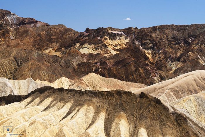 https://lightscrapes.com/earth-dreams/death-valley-california-badlands-and-mountains-at-zabriskie-point/
(2016, October 13). Death Valley, California – Badlands and Mountains at Zabriskie Point. Retrieved from https://lightscrapes.com/earth-dreams/death-valley-california-badlands-and-mountains-at-zabriskie-point/
https://lightscrapes.com/earth-dreams/death-valley-california-badlands-and-mountains-at-zabriskie-point/(2016, October 13). Death Valley, California – Badlands and Mountains at Zabriskie Point. Retrieved from https://lightscrapes.com/earth-dreams/death-valley-california-badlands-and-mountains-at-zabriskie-point/
Sunday, August 18, 2019
Week 7 - Death Valley
Stopping at Death Valley with just a limited amount of time,
choosing just three stops to visit is hard. With so many locations, our three
stops are Badwater Basin, Zabriskie Point and Devil’s Golf Course.
The first stop is Badwater Basin, which has a low elevation
of -282 feet, far below sea level. It is a salt flat which, to the eye, looks
almost like snow on the rocks. It is useful for us to notice how the land is
mostly flat up until the start of the water in the back as in the picture
below. Noticing small details such as that can help create our geologic map.

Photo retrieved from https://californiathroughmylens.com/2011/12/badwater-basin-death-valley-lowest-poin/
Zabriske point is another location within Death Valley, an
area which was likely created due to lakes. It looks like the rocks have been
eroded due to possible past hints of lakes, however were those the reasons that
there are lines running along the along many other spots of the peak?

Photo by Hemant Bhagwat, retrieved from https://www.pandotrip.com/zabriskie-point-the-iconic-site-in-the-death-valley-usa-11218/
The last spot is Devil’s Golf Course. Located within Death
Valley, this area is filled with lots of spiking salt. It is a very interesting
looking area, rather flat and surrounded by hills and mountains. While making a
map, it might be useful to find whether the cracks in the area were created thanks
to past roaming water, probably a lake just due to the size of it all.

Week 7 - Death Valley
Salt Flats - Death Valley
 |
| Salt Flats - Credit:doi.gov
I chose to visit Salt Flats in Death Valley. This spectacular visitor point is a collection over 200 miles of chloride, sulfates, and carbonates. Water drained from higher elevation and water from rainstorms creates short term lakes and as these lakes dry, the water evaporates and the salt remains.
Examining the salt flats further, I would question; How the salt ridges form on the surface of the flats? and Why is the design of the salt flats constantly changing?.
What I found was; Salt crystals expand, pushing the crust of salt into rough forms, and newly formed crystals ooze between mudcracks, sketching strange patterns on the surface of the salt flat. Passing rainstorms wash off windblown dust and generate a fresh layer of blinding white salt (NPS, 2015).
Other information that could be gathered is does the force of the rain, sprinkling versus downpour, have an affect as well. Does the force of the water cause some of the changes as well?
**National Park Service. (2015). Salt Flats. Retrieved from https://www.nps.gov/deva/learn/nature/salt-flats.htm
|
Week 7 : Death Valley Salt Creek
DEATH VALLEY: SALT CREEK
Jarrett Falasco
Salt Creek Death Valley
Salt Creek is a small, short permanent stream with fluctuating water levels with the water originating from springs upstream. It would be useful to see how the local faults in the area play a role in manipulating the springs and how this may be related to the main trace of the Death Valley-Furnace Creek fault zone which lies just east. The creek runs about a mile long and has a shallow depression running in the center of the valley. Most famously the creek is home of the isolated pupfish population which is a fish that only lives in this particular area. It would be beneficial to take research on the Pupfish to gather a greater understanding of the area which includes remnants of the wetter Pleistocene climates. The current creek consists of saltwater which was converted from a dried-up giant lake which took existed about 10,000 years ago. This area should be filled with a number of geological clues and possible fossils that could provide an indication of the type of climate creatures that lived in the area. A geological map would be useful in determining the size of the original giant lakes and their impact on today's local geology.

PUPFISH: SALT CREEK
SALT FLATS
 I chose to do Salt Flats. I thought that this one seemed super interesting because I read that it is too harsh to have most plants and animals to survive. It is formed by delicate crystals and the relatively thin upper crust of salt can break through to the mud layer. No cars are allowed to be on this. In the photo, you’ll see that it looks very different than a lot of areas were familiar with. So what causes this ? 1. sources of salt 2 enclosed basin and 3 having an arid climate. NaCl ( table salt) is the majority of the Badwater Basin and other minerals are calcite, gypsum, and borax. After thousands of years, enough salt has washed in to produce upon layer of salt crust. I included a video on youtube that gave great photos and videos of the salt and salt flakes. SUPER interesting because they are crystals and apparently sounds hollow underneath. https://www.youtube.com/watch?v=JVmUr6VHV9Mhttps://www.youtube.com/watch?v=JVmUr6VHV9M

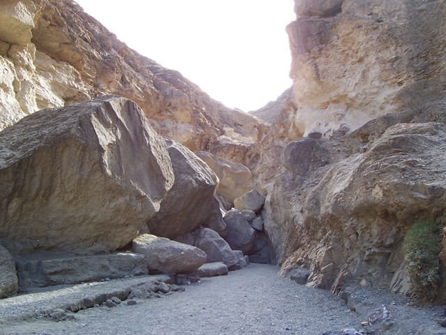
Week 7 - Mosaic Canyon - Death Valley
I
have decided to search more about the Mosaic Canyon in Death Valley because of
its interesting formation that can be explored while you hike, a sport that I
am extremely passionate about.
Mosaic
Canyon is a fine specimen the geology of Death Valley National Park and
surrounded with both mosaic conglomerates and smooth marbleized rocks.
The
canyon expansive gravel wash marks the top of the lower canyon and the end of
the most impressive part of the trail.
A
steep footpath climbs the ridge to the left of the wide opening. Above the
canyon, the path offers a wide view of the center of Death Valley National Park.
Mosaic
Canyon continues beyond the lower canyon. Head uphill across the massive
gravelly wash, where the massive wash narrows again, and the canyon walls
present more of the “mosaic breccia” conglomerate rocks that the canyon is name
for.
Mosaic
Canyon is frequently recommended to new visitors by park rangers, where you can
hike to the dry falls and back is four miles round trip with 750 feet of
elevation change.


Death Valley
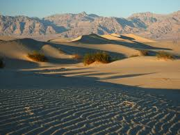
My first stop in Death Valley was to the Mesquite Sand Dunes. In the photo above you can see that
these dunes have ripples and a sort of reddish tone. These dunes were most likely formed from a
combination of wind and the surrounding mountains. The mountains can trap wind which then carries
sand which builds up to form dunes. In order to understand more about the Mesquite Sand Dunes, I
would like a sample of the sand and the rocks in the surrounding mountains. These samples would allow
me to figure out what the sand is comprised of. A geological map would also allow me to get more
information on the wind and mountains creating these sand dunes.

My next visit in Death Valley was to Golden Canyon. In this photo, you can see large rock formations
with colors varying from red to off white. While looking at the photo you can see that these rocks were
most likely formed and eroded from a large lake covering the area in the past. One piece of information
I learned relates to radiometric data. If I could use radiometric dating on the rocks closest to ground
level I could get an idea of when the lake surrounding this area existed. This would help me to better
understand Golden Canyon and how the Canyon was formed.

The last visit I had in Death Valley was to Badwater Basin, which is home to the salt flats. Badwater
Basin is the lowest point in the Continental United States. In this photo above you can see a flat
layer of salt that has formed into a unique diamond-like shape. This shape has sparked my interest
and I would need more information to find out why the shape is the way it is. One piece of
information I could use is data regarding the weather trends in Badwater Basin. With this information,
I would be able to see if rain or wind could have caused these shapes to form. My guess is that
rainfall in the Badwater Basin causes the salt to become wet and then during the summer the water
evaporates. After the water evaporates it dries out the salt-forming cracks.
Sand Dunes Death Valley
Sand Dunes
in Death Valley:
I have never
been to sand dunes. My wife was surprised as I brought this up to her. However,
all my experiences from dunes exist in my mind either from video games, or television.
My interpretation tells me that only sand exists. Mounds and mounds of it.
However, looking up additional information of sand dunes in the Death Valley
have shown me otherwise. One image in particular really caught my attention.
Rested between two dunes shows concrete colored rocks, flat, and resting
partially buried in the sand. Their shape appears to have layers reminiscent of
sediment layers you might find in a cliff side, although very compressed. This
rock is very intriguing to me and I would like to carbon date it to see how old
it is. I would also like to study any rock below the sand, no matter how far
below the sand. Finally, I would like to compare this dune rock, to rock at the
nearest cliff and exposed sediment layers.
https://www.google.com/maps/uv?hl=en&pb=!1s0x80c7440000000001%3A0xcfa4dc5d128efa34!2m22!2m2!1i80!2i80!3m1!2i20!16m16!1b1!2m2!1m1!1e1!2m2!1m1!1e3!2m2!1m1!1e5!2m2!1m1!1e4!2m2!1m1!1e6!3m1!7e115!4shttps%3A%2F%2Flh5.googleusercontent.com%2Fp%2FAF1QipNa9dCKke_LcBWJWRFM6Etdcc60m4Y1T-q8K77O%3Dw120-h160-k-no!5ssand%20dunes%20death%20valley%20-%20Google%20Search!15sCAQ&imagekey=!1e10!2sAF1QipPaDN27QuXNE7HWs21o2IqZaV0mg3Pe5oh-ceTp&sa=X&ved=2ahUKEwj3sojkgI7kAhVCo54KHRqdDi4QoiowJHoECA4QBg#
Field Trip Travel Journal: Death Valley
For this field trip I chose Harmony Borax Works at Death Valley for the location I would like to dive into. It is known for a plant company in the late 1800's that produced borax despite the least of conditions and resources back then. Either way looking at this site a few question come to mind, such as why was this land rich in borax? I now know borax is formed from evaporated saline lakes. Makes me wonder was this vast valley underwater just as Colorado once was, was there a lake here where Harmony Borax Works is now? Is this the sediment left over?

 In the photos above I can see see the rocky mountains in the background that can either be faults, leaving me to believe this remote desert surrounded by rocky mountains might be the next Colorado for all we know.


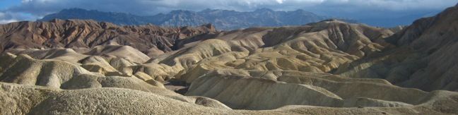
Week 7 Death Valley
The photo
I chose of Zabriskie Point shows massive dunes within the desert habitat. A
lake is visible in the distance and caught my eye. My thoughts wandered towards
the cause of this lake to subside and water to be present only in that area? Why are the dunes jagged and sharp in their definition? Did water form the dunes that are seen in the picture? Or was something else
responsible? A geological map would help me to decipher if the sand present was
made of the same material as that found in lakebeds within the area.

Gower Gulch loop-Death Valley, California
Keith Lawlor
This week I decided to visit Gower Gulch in Death Valley. We all wondered why this section of Gower Gulch looks so remarkably different from the surrounding landscape and later on I learned that it’s the result of human activities the gulch was breached on its eastern reaches to divert the flow of Furnace Creek away from the Inn during flash floods. So, as a result, the upper reaches of Gower Gulch are now far more eroded than they should be and they have those foreign rocks lining the wash instead of pieces of the surrounding badlands.

This wash is at first rather wider than Golden Canyon but has similar bright colors and stark, eroded formations. For about half a mile the floor is flat and sandy, bordered by sloping sides beneath more polychromatic dunes, then the gulch becomes more enclosed, rocky and steep-sided, with one narrow place and a four foot dry fall. Around here are a number of tunnels, relics of borax and calcite mining from the early 20th century. This man made breach seems to be eroding Gower Gulch loop at an incredible pace. But my question is what effect is it having on the eastern valleys, as the flood water is diverted into it?
Badwater Salt Polygons
For this week's travel journal, I chose the Badwater salt flats as my subject. Not only are the Badwater salt flats the lowest point in North America at 282 feet below sea level, but they are also home to a grueling 135-mile ultra marathon. The photo I chose shows the polygons formed in the salt-infested ground. This got me wondering about how the salt rises to form these polygons. I have seen photos of the desert where the ground breaks, so the shape of the polygons in Badwater seems somewhat normal. I am really curious as to how the salt forms around these cracks.

Rausch-Week 7: Death Valley-Mosaic Canyon
The wife and I have decided to venture to another National Park in California; the under appreciated Death Valley National Park. After researching through many localities and trails, we decided to explore the fascinating Mosaic Canyon.

Mosaic Canyon-Death Valley National Park
Retrieved from https://www.nps.gov/deva/planyourvisit/mosaic-canyon.html
As we ventured on our hike through the canyon, I discovered the origin of the locality's namesake; the "mosaic" of rocks in the canyon's walls. I first questioned whether this collection of cemented rocks was conglomerate or breccia. After utilizing the knowledge I have to be able to differentiate between the two, I was able to deduce that the walls contained vast amounts of breccia.
Mosaic Canyon-Breccia
Retrieved from https://www.nps.gov/deva/planyourvisit/mosaic-canyon.html
The presence of breccia is important in understanding the formation of Mosaic Canyon as it allows one to understand that the transport of the sedimentary deposits was from a short distance, since the particles in the breccia are angular in shape as opposed to being rounded conglomerate(suggesting water-based transport from long distances). In fact, the breccia formation in Mosaic Canyon is believed to be the result of mudflows racing down mountainsides and picking up many different rocks and carbonates. These carbonates are typically picked up from the Noonday Dolemite formations that comprise much of Mosaic Canyon.

Noonday Dolemite Walls-Mosaic Canyon
Retrieved from http://www.exploretheusa.com/Mosaic_Canyon_Death_Valley_National_Park_-_A_Geologic_Walk_Through_Time
References
BackRoadsWest.(2019). Death Valley. Retrieved from http://www.backroadswest.com/deathvalley/MosaicGeology.htm
ExploreTheUSA.(2019).Mosaic Canyon, Death Valley National Park-A Geologic Walk Through Time. Retrieved from http://www.exploretheusa.com/Mosaic_Canyon_Death_Valley_National_Park_-_A_Geologic_Walk_Through_Time
Saturday, August 17, 2019
Week 7 - Badlands Loop
Badlands Loop
Kevin Kapka
After reviewing the website, the route, I chose to walk in Death Valley is called the Badlands Loop. The reason why I pick this route was because of this route is most popular among hikers. When hearing how popular this route was it totally intrigued myself and I wanted to know why. After doing some further research it all made sense and hopefully by this picture below it shows the kind of scenic views throughout the journey. Overall, the park describes this route as a moderate difficultly which appeals to a wider range of people. Round trip it will roughly take 2 hours to walk and it is a little under 3 miles. This route is a former lakebed, so which has now turned into desert or known as Death Valley.

Work Cited
Badlands Loop State Scenic Byway. (n.d.). Retrieved from https://www.blackhillsbadlands.com/scenic-drives/badlands-loop-state-scenic-byway
Friday, August 16, 2019
Davidson Field Trip Travel Journal - Week 7 Entry
Hells Gate – Death Valley, California
My travels took me to the Hells Gate region of Death Valley. There are fault lines here where large sections of land are shifting. The information that would be beneficial, in constructing a geological map, are the age and type of rocks. My question, as I look across this valley, is where the fault lines are and how far they have shifted. A geological map of the area would show rock formations cut by this fault and where they reside today. I could extrapolate where they started based on the matching patterns on each side of the faults. I can see larger course rocks that have not been eroded and seem out of place. I would question what formations these came from and use the map to determine if any larger formations of the same material are nearby. A geologic map would help me to determine what lies under this valley and if the mountains I see in the distance are uplifted from the same deposit or if they are from an older deposit that hasn’t eroded away as quickly as the material that was in the valley.
My travels took me to the Hells Gate region of Death Valley. There are fault lines here where large sections of land are shifting. The information that would be beneficial, in constructing a geological map, are the age and type of rocks. My question, as I look across this valley, is where the fault lines are and how far they have shifted. A geological map of the area would show rock formations cut by this fault and where they reside today. I could extrapolate where they started based on the matching patterns on each side of the faults. I can see larger course rocks that have not been eroded and seem out of place. I would question what formations these came from and use the map to determine if any larger formations of the same material are nearby. A geologic map would help me to determine what lies under this valley and if the mountains I see in the distance are uplifted from the same deposit or if they are from an older deposit that hasn’t eroded away as quickly as the material that was in the valley.
 |
| Retrieved from https://t4.ftcdn.net/jpg/02/61/20/33/240_F_261203366_NgwZcv5Y5BhhGtw5pbXxqWlDBMmukQmy.jpg |
 |
| Retrieved from http://www.itoda.com/photos/mojave-desert/peaks.html |
Wednesday, August 14, 2019
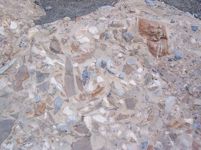
Week 6 - Siskiyou County

Siskiyou county contains Mount Shasta. Mount Shasta is a cone volcano that has had four volcanic cones. It not currently an active volcano, but it is believed that it will erupt again. It is the fourth tallest mountain in California, and it has several glaciers on it.
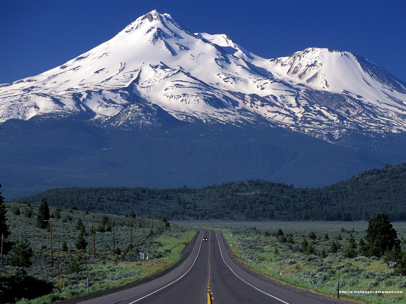

I would ask for seismic data to help understand what the volcano is doing. This can give us an idea if the volcano is becoming more active or not. I would use absolute dating to determine the age of the lava flows, and this would help determine the last time the cones erupted. I would want to know how big the glaciers are. I would like to know how big the glaciers are to determine how big of an impact they could have if the volcano erupted.

Chris Culver - Death Valley

In the Death Valley national
park there is an easily visible fault line called the Hanaupah fault.
The picture above shows a clean fault line visible on the surface
that runs left to right as a result of many breaks in the fault over
time. The erosion in the hillside show sines of water running down
from the mountains during a rainy season that flows down into the
hotter lower elevation.

The salt flats in Death Valley are interesting as they show signs of a previous body of water that has evaporated over time. The thought of a place as barren and dry as Death Valley having a lake at one point in time is very interesting. When traveling to the main gate of Edwards AFB you get to drive on a road built on top of one of these salt flats.

The Ubehebe Crater is intersting as lava reaching the surface heats water to create steam which then blows material up and out creating these craters. The faults in this area that builds local mountain ranges also are responsible for forcing the lava to the surface.
Tuesday, August 13, 2019
Week 6 Geological Interpretations Big Sur California
The area in Big Sur along Highway 1 in California was the area I
chose to visit because it was a favorite destination for my family thanks to
the beautiful scenery and wonderful hiking trials. While there I chose to study
landslides, which can cause an enormous impact on traveling and other safety concerns
to the oceanside highway and its diverse location along the coast.

The first tool I’d request to use is any available map on the area
from the United States Geological Survey (USGS) department. Maps are useful tools
to present information on landslides with varying degrees of contents. For
example, the USGS broke down a three-stage approach to landslide mapping by using
regional or reconnaissance mapping, community-level mapping, and finally
site-specific large-scale maps. When we’re dealing with a specific like, like
the area surrounding a landslide prone Highway 1, then the USGS recommends bypassing
regional mapping and concentrate on fewer known areas of concern. One such
product released by the CGS is referenced at https://www.arcgis.com/apps/webappviewer/index.html?id=bc48ad40e3504134a1fc8f3909659041
which is a regional aggregation map for landslide impacted areas. The tool
includes a reference photo of the landslide event and other descriptive fields
about the site. Other example maps might include a landslide inventory map of
previous landslides and areas of concern where we might start our investigation
of recommended sites to start researching.
Secondly, I’d request to use several imaging tools which will help
us our study of landslides in the area. Most notably are the aerial photography
remote sensing and InSAR Imaging. Aerial photography remote sensing can help us
identify vegetation cover, topography, drainage patterns, soil drainage characteristics,
surficial geology, and several other key factors which might be indicators of a
potential landslide area. The USGS recommends studying recent and past aerial
photographs visual aids whenever possible to identify characteristics of our
chosen site to help compare potential similarities of past and present landslides.
Finally, my last tool I’d request to use is real-time monitoring instrumentation. At this point, we’ve identified where a potential landslide might occur through mapping and image analysis, therefore we’d need to use instruments to monitor the potential area to warn other people of potentially deadly landslides. USGS recommended to use real-time instrumentation last due to the prohibitive cost impact of using instrumentation because it requires licensed professionals and a constant cost of use for all the equipment and professionals needed to monitor the area.
References
Appendix B. Introduction to Landslide Evaluation Tools— Mapping, Remote Sensing, and Monitoring of Landslides
Subscribe to:
Posts (Atom)