Wednesday, July 31, 2019


Hello, everyone!
I would like to share some important information about the trip that I took a moth ago, to a place called Nazca plate, in Peru.
The Nazca Plate is an oceanic tectonic plate in the eastern Pacific Ocean basin off the west coast of South America. The ongoing subduction, along the Peru-Chile Trench is greatly responsible for the Andean orogeny. The Nazca Plate is bounded on the west by the Pacific Plate and to the south by the Antartic Plate through the East Pacific Rise and the Chile Rise. Its movement has created some volcanic islands, as well as east-west running seamount chains that subduct under South America. It is a relatively young plate both in terms of the age of its rocks and its existence as an independent plate having been formed from the break-up of the Farallon Plate about 23 million years ago.

Tuesday, July 30, 2019

Converging Plates - Shi Shi Beach, WA

Shi Shi Beach, Clallam Bay Washington

This week I traveled to Shi Shi Beach in Clallam Bay Washington where the Juan de Fuca and North American Plate converge. Here you can see the results of the Juan de Fuca plate being pushed underneath the continental landmass of the North American plate in a reverse fault. The forces happening at this margin are compressive as we can see anticlines formed into the ridge just off the beach shoreline. For the majority of this ridgeline, the fault is dominated in the structure. The fault has faces that were not a form of heat and pressure, but more of breaking and jutting upwards over the converging plate. The surrounding hills seem to have been formed through pressure forcing the rock to fold and rise higher in the air over long periods of time.

Monday, July 29, 2019

Volcano

The Volcano I have visited in Mount Rainier. Since moving to Washington, there has been a lot of speculation that it will possibly go off in the next 50 to 100 years. Hiking on the mountain makes my wife and I a little nervous, but it is the most beautiful place I've ever hiked. Mt Rainier, like its sisters, is formed due to a converging plate boundary. Two converging plates in the Pacific Northwest have created a mountain range and volcanoes. There sure are a sight to see during a clear summer day, as the volcanoes tower over the rest of the mountain range! This volcano is still considered active, and evidence of past lahars in the valleys below are still present. For this reason, many towns in the danger zone have volcano evacuation signs, and suggest people have a plan in case Rainier decides to burst. Anyone in the zone will be covered with mud flows. We chose to live in Graham, Washington where volcanic lahars will flow around us. 

Week 4 - Volcano -


This week we visit the volcano Popocatépetl, located on the border between Mexico state, Puebla and Morelos. The volcano is part of the ring of fire, and is still an active volcano and there could not have been a better time to visit – on July 25th the volcano erupted two times. Ash from the volcano has been a concern, and the public has been warned to prepare to evacuate.

Popocatépetl spewing ash (Martin, 2019)

This volcano lies within the North American Plate, rather close to the boundary of the Pacific Plate and the North American Plate. It is located in central Mexico thanks to the fact that it is part of the Ring of Fire. The volcano has had explosive eruptions, spewing ash at large heights. The biggest hazard for Popocatépetl is the ash as well as the gasses that are released from the volcano. The volcano does spew out lahars as well. As it is still erupting, it is more likely to continue to erupt for a long time as well.
For some further reading:

References:
Martin, S. (2019). Mexico volcano eruption: locals told to prepare to evacuate as Popocatépetl erupts twice. Express. Retrieved from https://www.express.co.uk/news/science/1158193/mexico-volcano-eruption-Popocat-petl-erupts-popo-ash-cloud-video


Week 4 _ Volcano Eyjafjallajökull

Eyjafjallajökull Glacier Volcano - Iceland


Since there is not much in the way of visiting a current or past volcano site here in Long Island I figured we could take a little imaginary travel journal to Eyjafjallajökull in Suðurland, Iceland.  The most interesting thing about this particular volcano is not its name but that it is a large ice cap that covers the caldera of a moderately active volcano.  The mountain itself stands 1,651 meters (5,417 ft) at its highest point. It has a crater 3–4 kilometers (1.9–2.5 mi) in diameter that opens to the north.

The last eruption from Eyjafjallajökull was in 2010 and which started with lava flows from new fissures while melting the glacier ice that covered it.  The rapid vaporization created a rush of ice melt that flooded local rivers in the area.  The eruption of phreatomagmatic explosions (when water reacts with magma) created a plume of ash 7 miles high into the atmosphere causing all air traffic into the island to be delayed. The plume could be seen from space.

Image result for Eyjafjallajökull from space


Eyjafjallajökull eruption from Space


Eyjafjallajökull volcano or the glacier volcano is part of Iceland's Eastern Volcanic Zone and is believed to be linked directly to the activity of Katla volcano which is located 16 miles away.  Eyjafjallajökull is the 6th largest volcano in the area of 31 active and extinct volcanos.  There have been a total of 18 eruptions since humans started settling on the island.  

Figure (see Caption)
Iceland's Volcanic Zone
The volcano to me is extremely iconic for the region and its eruption is well depicted in one of my favorite films, The Secret Life of Walter Mitty.  Although currently Eyjafjallajökull is not predicted to have another eruption in the foreseeable future it has not been ruled extinct just as of yet.    
Image result for eyjafjallajökull dormant
Eyjafjallajökull Volcano/Glacier
Resources: 
Rafferty, J. P. (n.d.). Eyjafjallajökull volcano. Retrieved from https://www.britannica.com/place/Eyjafjallajokull-volcano
Laughlin, S. (n.d.). Eyjafjallajökull eruption, Iceland: April/May 2010. Retrieved from https://www.bgs.ac.uk/research/volcanoes/icelandic_ash.html

Sunday, July 28, 2019

Week 4 - Mount St. Helens


Credit: National Geographic

Mount St. Helens, located in the rain-laden Pacific northwest in Washington State, was always a mystery to me as a child because its eruption was still very real to my parents during my childhood. I jumped at the chance for a field trip to the mountain going through grade school. Noted as one of the most active volcanoes in the US by National Geographic, Mount St. Helens last eruption occurred in 1980. The event killed 57 people and flattened more than 518 sq. km. (nearly 200 square miles) of forest around the volcano (National Geographic, 2010).

I remember as a child that the trek by car to the mountain was eerily fun because we went in the late 80s and early 90s. The landscape was much different than what you’d see today nearly 40 years later. The forests which dotted the landscape were nearly wiped out, but those that remains were charred and blasted stumps. Volcanic and other sediment clogged many of the rivers which left the geography completely altered compared to before its eruption.


Credit: USGS

The eruption of Mount St Helens was classified as a “Plinian” type eruption (USGS) which are among the most violent and powerful eruptions that occur. The resulting eruption sent ash into neighboring states, as my parents who lived in Oregon at the time, pointed out to me during our drive into Washington. What did this mean at the time for them? Being in Oregon, it was a relatively minor inconvenience, but it was quite dangerous for nearby observers and residents. Rock and superheated gas blanketed the northern area of the mountain after an initial earthquake revealed the volcanic dome before it’s eruption in 1980. The gas and ash blanketed the skies until it finally erupted, where the eruption itself was equated to roughly 15 atomic bombs that were dropped in Hiroshima.

The mountain is still monitored today for volcanic activity and, as of 2012, it was on the list as the 2nd most dangerous volcano in the United States. If it were to erupt again, an ash plume could reach up to 30,000 feet and blanket the Pacific northwest in ash and other sediment in as little as 5 minutes.  The renewed glaciers atop the mountain could also devastate the ecosystems for the valleys surrounding the mountain as runoff carries debris and ash into them.

Week 4- Volcanoes

In this week's imaginary visit, I traveled to Mount St. Helens. Mount St. Helens is located in
Skamania County, Washington and is apart of the Cascade Range of the Pacific Northwest.
Mount St. Helens is an active volcano and the last major eruption happened in 1980. In 1980 an
earthquake occurred below Mount St. Helens which caused a major landslide and large eruption.
This eruption caused the top 1,300 feet of the volcano to explode. This explosion caused ash to
cover multiple surrounding states.  Mount St. Helens has an elevation of 8,363 feet and is
considered as a stratovolcano. A stratovolcano is formed over thousands of years from multiple
eruptions. These eruptions cause magma, ash, rock, and other materials to explode and build up
around the molten center creating a dome shape. As the years go by these materials solidify and
create layers that cause the volcano to increase in elevation.
Since Mount St. Helens is a stratovolcano, it is likely to erupt again. Mount St. Helens has an eruption cycle of 100-300 years and alternates between dormant and active. The reason why we know Mount St. Helens will erupt again is because of its history being documented by the Native Americans. These eruptions in the past have been very explosive and dangerous. In the future, we can expect Mount St. Helens to affect the local cities, the state of Washington and even the surrounding states. Stratovolcanoes are one of the most dangerous volcanoes because they don't just spew lava but instead erupted with great force. 
The reason why Mount St. Helens is located in Washington is because of Washington’s location.
Mount St. Helens is apart of a series of volcanoes that is called the ring of fire. The ring of fire
spans a great distance surrounding the pacific ocean. The ring of fire is comprised of 450
volcanoes with a very active earthquake presence. The reason why there are so many
volcanoes and earthquakes in the ring of fire is because of the tectonic plates. These tectonic
plates located in the ring of fire make up a transform boundary. A transform boundary means that
the plates move sideways which creates a large amount of pressure that is released in the form
of earthquakes and volcanic eruptions. 

After reading and researching Mount St. Helen's I plan on trying to visit it in the near future. The history is rich and it is only 76 miles from Portland which makes it very accessible. 

Week 4 - Volcanoes Mount Vesuvius


Mount Vesuvius is a volcano that formed inside another volcano. The original volcano was Mount Somma, and Mount Vesuvius formed inside the caldera. The volcano is formed at the subduction zone created by the African plate as it goes under the Eurasian plate. 


The last eruption of Mount Vesuvius was in 1944, but its most famous eruption was 79 A.D. This is when Pompeii and Herculaneum. It is considered an active volcano and it is believed it will erupt again. Mount Vesuvius erupts explosively. Age and eruptions are detected by collecting rocks and dating them. They sometimes drill to collect older rock.


Mount Vesuvius is an especially dangerous volcano. It is surrounded by densely populated areas. It has Plinian eruptions that cause huge ashfalls and pyroclastic lava flows. This is what doomed Pompeii and Herculaneum. Pompeii is a unique area where the ash froze the town and its people in time.


Vesuvius currently only has minor seismic activity and outgassing from its fumaroles.


References
Mount vesuvius, italy: Map, facts, eruption pictures, pompeii. (n.d.). Retrieved July 29, 2019, from https://geology.com/volcanoes/vesuvius/
What’s the most recent eruption of Vesuvius and will it erupt again? | Volcano World | Oregon State University. (n.d.). Retrieved July 29, 2019, from http://volcano.oregonstate.edu/what%E2%80%99s-most-recent-eruption-vesuvius-and-will-it-erupt-again
Vesuvius volcano. (n.d.). Retrieved July 29, 2019, from http://www.gso.uri.edu/vesuvius/Vesuvius/Vesu.html

Week 4 - volcano - Alessandra Noronha do Nascimento


Hi, all!

I would like to tell about the great experience that I had going to Chile this past summer, for vacation. I am fascinated by volcano, which I think I was in one of the best places for that, where there are volcanos both active and non-active. I will mention the Paranicota volcano because it was the first one that I visited, which became very special because it was a dream coming true!
Paranicota volcano lies on the western margin of the Altiplano in the Central Andes. The border between Bolivia and Chile bisects the volcano and runs along the rim of the crater, which lies in Bolivia. In Chile, where most of the edifice is located, Parinacota lies in the commune of Putre, Arica y Paranicota Region, and in Bolivia in the OUro Department of the Sajama Province. The towns of Ajata and Parinacota lie southwest and west of the volcano, respectively. The region lies at high altitude and access is difficult, hampering research on the volcanoes of the Central Andes.
I didn’t really know how high a volcano could be and I must confess that I was amazed to see it and hear that Paranicota has 6348 meters of altitude! Paranicota is a stratovolcano, which means, a volcano built up of alternate layers of lava and ash, and it is locate both in Bolivia (Sajama National Park) and Chile (Lauca National Park).
    Global Volcanism Program/Parinacota


Volcanos - Niki

This week I chose to write about the infamous volcano, Mt. Vesuvius.
Mt. Vesuvius is located near the Bay of Naples where it has had its signature of more than 50 eruptions. Especially its most famous volcano during 79 AD where it buried the ancient Roman city of Pompeii. The thick volcanic ash "poured across the land" where it killed 2,000 people and left the city abandoned for many years. However, the most interesting thing about this was that when they went back to this area in 1748 they were shocked to see that most of this place was intact. 
More about Mt. Vesuvius - it was a part of the Campanian volcanic arc that is all along the African and Eurasian tectonic Plates on the Italian peninsula

 and had been erupting for many many years. For instance, 1780 BC "Avellino eruption" had shot millions of tons of superheated, ash and rock about 22 miles into the sky. 
Great video to watch more about the lost city of Pompeii I found interesting - https://www.youtube.com/watch?v=DeB5N_bH7E8


Week 4 - Volcanoes

Symmetrical structure of the Mayon Volcano from southeast of Luzon, Philippines.
This week, we tried touring one of the most active volcanoes on Earth, the Mayon Volcano. It rises at about 2,462 m. above the Albay Gulf located in Luzon, Philippines. The Mayon Volcano is known as a stratovolcano, as its symmetrical structure is due to its central conduit of eruptions. Its historical predominant and frequent eruptions date back as far as 1616, ranging from strombolian (eruption of jetting clots of rocks) to basaltic plinian (large, tall, and steady eruptions at high velocity). Its lava flow is considered pyroclastic, fountain-like, long, and dangerous as it commonly causes devastation to populated lowland areas. In 1814, the eruptions of the Mayon Volcano caused devastation to towns and fatalities of over 1,200 residents. In 1993, an unexpected 30 minute eruption and pyroclastic lava caused 68 fatalities and evacuation of about 60,000 residents. In 2018, the Mayon Volcano released an intensive stream of a strombolian eruption and smoky and ashy clouds. Its lava traveled about two miles and 7 minutes to an hour down causing an evacuation of 30,000 residents. Based on researches from volcanologist and postdoctoral researchers of the Philippines, the status of the Mayon Volcano is at a level 3 out of 5, meaning that it is at high unrest. Taking this into consideration, we remained in areas of the Luzon Island that had impressive views of the Mayon Volcano. 

Devastation of a lowland area caused by Mayon volcanic eruption in 1814.
Mayon Volcano eruption of lava in 2018.
Most recent satellite thermal activity view of the Mayon Volcano.


References:
-Oregon State University. Article: Volcano World; Mayon. Link: http://volcano.oregonstate.edu/mayon

-Wei-Haas, Maya (2018). Article: Geology Makes the Mayon Volcano Visually Spectacular and Dangerously Explosive; What’s going on inside one of the Philippines’ most active volcanoes?. Link: https://www.smithsonianmag.com/science-nature/how-geology-makes-mayon-volcano-beautiful-and-dangerous-180967897/


Ty Week 4: Mount Vesuvius


Mount Vesuvius

This week I traveled to the famous (or infamous) Mount Vesuvius volcanoe on the west coast of Italy. Mount Vesuvius is famous for its eruption in 79 A.D. that destroyed the cities of Pompeii and Herculaneum. Although the eruptuion that destroyed the two cities is arguably the most famous of Vesuviuses eruptions, it has erupted at least fifty other times that scientists are aware of. Mount Vesuvius sits on the Companian Arc which sits on a tectonic boundry which means it sits on a convergance zone. During past eruptions, Mount Vesuvius has had catastrophic eruptions that brought both clouds of ash that covered cities, but also pyroclastic flows of lava that reached the ocean because the magma was mainly comprised of andesite. Andesite has been known to cause both violent eruptions and consistent lava flows due to its medium density. Mount Vesuvian eruptions can shoot ash and lava multiple kilometers into the air in the shape of what looks like a tree which is known as a Plinian eruption. During the explosion tht destroyed Pompeii it was obviously in an explosive state and has moved back and forth frome a state of inactivity and activity since. Its last eruption was in the 1940's but it is still considered an active volcano, however it is in a state of quiesence. Mount Vesuvius has many hazards that could accompany another eruption because of the close proximity to large towns like Naples Italy. It is estimated that over two million people live in the shadow of Mount Vesuvius. So a large eruption(s) could have the potential to harm a large amount of people. As Mount Vesuvius is an active volcano it i not a question of if it will erupt again, but when. The only question tht is not certain is how large the eruption will be and how long will the volcano remain in an explosive state.


Credit: Science.howstuffworks.com


River Liffey (Dublin, Ireland)

Image result for river liffey


River Liffey (Ireland)


The river Liffey is one of the most important rivers in Ireland, it accounts for 60% of Dublin’s fresh water. It flows through three counties, Wicklow, Kildare and Dublin and stretches over 82 miles long. At its source, the Liffey is only 12 miles from the ocean, but as we know gravity guides water and adds an extra 70 miles to its journey from the mountains to the ocean. Upon first seeing the Liffey the first thing you notice is the dark brown color of the river. This signifies a rough ride from the source to the mouth of the river.

The Liffey starts at its headwaters in the Wicklow mountains at an elevation of 1,600 feet between the Kippure and Tonduff mountains. The terrain is rough and full of large granite rocks deposited from glaciers. Not an easy hike, and comfortable shoes are needed. The Wicklow mountains are known for their heavy rain fall and this causes a lot of sediment production.

 The sediment production is extremely corrosive, as the rain fall in this mountain range is continuously year long and can become extremely powerful in the wet winter months. This makes the Liffey a perennial river as the large rainfalls keeps the river in constant motion. At its source, the water has a turbulent flow which can quickly change and sculpture the path of the river and the terrain. The terrain that surrounds these mountains is mainly consisting of granite with a top level of mud and clay. The bed of the river in this region is bedrock with very little dirt, which makes the river’s water clear. The banks of the river are surrounded by rough pointy granite, in which the river has eroded the top level of soil exposing the granite. This makes the terrain extremely vulnerable against large volumes of rain fall and has resulted in the formation of a V-shaped valley that flows between the Kippure and Tonduff mountains. This V-shaped valley is where its major tributaries include the River Dodder, the River Poddle and the River Camac flow into one to make the Liffey. Flooding in this area is highly unlikely as the gradient slopes down to the lowlands.

As the river makes its way down from the mountains, we find its path has brought it to County Kildare. When it reaches this area, the river reaches its Sediment transport area. Here the rivers discharge slows down, and the erosion is not as damaging as the sediment production stage. This is where the Liffey water starts to darken as the runoff from the Sediment production slows down to produce a dark murky water.

Dendritic pattern is the most prevalent drainage pattern on the Liffey’s path. This is due to the slope of the land. The Liffey starts at the top of a mountain and works its way down to the ocean. But a funny fact about the Liffey is that at its source it is only 12 miles from the ocean, but because water is influenced by gravity, it slopes away from the ocean and heads back into mainland Ireland.  This region is mainly limestone and this sediment rock is weak against the corrosive powers of the river. The gradient in this area is almost flat, but the powerful force of the rivers flow velocity from its source helps the river carve its way through this region. This causes the river to meander through the flat lands of Kildare (Known for its flat and fertile agricultural land). Due to its geographical location, Kildare is considered a flood plain and usually floods after a heavy week of rain. Although both sides of the river have natural levees, they are unable to hold the overflow in heavy rain conditions. Both sides of the riverbed are surrounded by back swamp, which indicates that floods are very present in this area.  Luckily most of the land that surrounds the river is agricultural land and does not cause a mass concern for large populated towns in the region.

This has caused the formation of many Oxbow lakes along the rivers path, shortening the gap to the ocean. Most of these Oxbow lakes have dried up but in some ephemeral cases at high water levels some of these Oxbow lakes can become part of the river again until the water levels retreat.

As the river reaches the graded conditions downcutting becomes less dominant. The meandering pattern causes the energy of the river to erode the sides or banks of the river, resulting in the valley widening. At its heaviest turbulent flow, the Liffey is measured at 25 feet wide, but once it reaches its graded conditions the river can widen up to 70 feet wide.

Sediment Deposition is where a river meets the ocean, for the Liffey this happens in the heart of Dublin City. In the Gaelic language Dublin is known as Baile Atha Cliath, translated into English it means the Black River. This is due to the large discharge of water slowing down and turning into a laminar flow as it approaches the ocean. This murky water is a result of sediment deposition as the river loses power the sediment is deposited at the mouth of the river, resulting in a dark sediment depository consisting of mud clay and sand particles.  Most of these sediments are washed out to sea, but the Irish government does have to dredge the riverbed every couple of years. This is due to the fact that Dublin Port sits on the river’s mouth, and for hundreds of years this was a major port for trading importing and exporting goods. So, to keep this trade route open for business the delta which once sat at the rivers mouth has long being dredged so larger boats can enter the port.

As the river enters Dublin city, it is surrounded by large walls that act as levees. These levees have a 20-foot clearing from its water level. This is to prevent floods within the city, as history shows floods were not unusual until the building of these manmade levees. In the last century, Dublin city only flooded once since the levees were put in. So, this is a good indication that the city of Dublin is well protected from flooding.

One interesting fact about the Liffey is that it runs most of its course over limestone. This sedimentary rock formed millions of years ago beneath the sea. This has an important impact on the river as limestone is more alkaline, creating more conducive conditions for fish such as trout to thrive. This one of the main reasons Dublin became a settlement for its fresh water and unlimited fish.
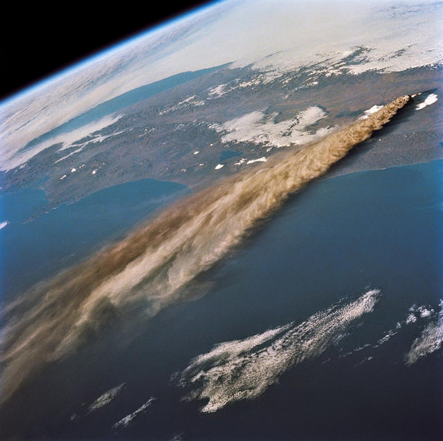
Week 4- Volcanoes

I went on a trip to see Mount Mayon in Luzon, Philippines. It is an active stratovolcano, that is very popular with hikers and campers. It's constant eruptions, however, force thousands of people to evacuate the surrounding areas occasionally. Since 1616 there has been about 30 eruptions and Mayon is very likely to erupt again in the near future. It is also known for having the world's most perfect volcanic cone. The scenery around the volcano is really pretty, hosting plenty of trees and other greenery.

https://www.britannica.com/place/Mayon-Volcano


Igneous Rocks


Igneous Rocks:


Image result for red rocks


This weekend I decided to go visit one of my favorite places in Colorado, Red Rocks amphitheater. It was formed over 300 million years ago. The first time I saw this rock formation it instantly brought me back to my childhood days of watching old western movies. The rocks just reminded me of a canyon a cowboy would seek shelter in. The red rocks point upwards to the sky in a spectacular display. Considered an early version of the Rocky Mountains or ancestral Rockies, they rose and shed their gravelly sediment in the oxygen rich atmosphere of Pennsylvanian times. 

The color is what caught my attention the most, rich with iron oxide and pink feldspar grains give the beautiful stones their magnificent color. The red rocks contain many layers of a cross bedded red fusion of course to fine grained sedimentary rocks called the conglomerate fountain formation. In many places, the fountain formation lies directly upon Precambrian granite, aged at approximately 1.9 billion years old.

            An uplift of the current Rockies occurred some 72 to 45 million years ago, all the sedimentary red rocks here were pushed up at a near 40-degree angle seen at this angled tilt today. Sculpted by times’ patient chisel this ongoing carving is forever shaped by wind and waters power struck hammer blows checked by weathers erosive freeze and thaw.   The Fountain Formation, Morrison Formation and the Dakota Sandstone Formation rest more than two miles and 10,000 feet underneath the layers of Denver and yet sticks up here in the Foothills of Morrison.

If you look closely, you’ll see pebble- to fist-sized chunks of other rocks embedded in the amphitheater’s red rocks. Chunks this large can’t be transported far from a mountain range, so their very presence in the Fountain Formation, which predates the modern Rockies by hundreds of millions of years, indicates that they were shed off an older mountain range (Cook, 2015).


References


Cook Terri, (2015). Colorado By Nature: The Geological History Of Red Rocks. 5280.com, Sourced From: https://www.5280.com/2015/05/colorado-by-nature-the-geological-history-of-red-rocks/