Sunday, December 13, 2020

Week 8- Global Warming

 Many Coastal Cities Including New York, London and Sydney Will Drown In  Coming Future As Glaciers Are Melting Fast, Says NASA

This week I decided to take a trip into the future to New York City. The first thing that I notice is all of that the city consists of newer more modern buildings. However, these buildings were built thousands of years ago and now in the year 7010 much of the city is completely underwater and uninhabited. Global society saw the dangers of the rising sea levels however failed to take the measures to prevent this from happenings. Fossil Fuels were not eliminated as early as they should have been and the planet continued to suffer as a result. The repercussions of our actions in the past are felt worldwide, however I believe that society has taken steps to strive for sustainability and protection of the planet. Unfortunately global warming has had severely detrimental affects on the world. 

Week 8 - William Moran - Global Warming

 I traveled 5,000 years into the future and am currently floating over what was Los Angeles, California. I never thought we would be living in such a dystopic future. There isn't enough land for everyone to comfortably live on anymore so most people live in floating cities. The closest comparison to what I'm currently viewing is the movie Water World. Since the onset of the Industrial Revolution in the 1900's the world has been in a slow decline. Very few governments had Carbon reduction plans in place and by the time they did, it was too late. The greenhouse gasses caused such a significant rise in temperature that the polar caps are almost nonexistent in 7010. If leaders of the free world 5,000 years ago could see what 7010 looks like maybe they would be in more of a rush to fix the damage that we have done.

Week 8 - Joshua Rosson - Global Warming

 In the year 7010 the sea levels have risen since we were late to adapt to understanding the impact that global warming will have. Although we tried to fix these issue with agreements like the Paris Accord where some countries mitigated the impact of emissions we were giving off, other countries increased their emissions as they went through their own advancements. However, we have learned to pivot in how we live as a society. There were several occasions that we learned that many jobs can be done from home thus reducing individual emissions. As more sustainable farming practices have been implemented we used less land for farming as well as reduced emissions. However, we have not forgotten the repercussions of our actions. The coast line of Florida is completely submerged, and all that are left are crumbling sky scrapers that are homage to a time when the land was once a tropical paradise.


(Photo Source: Mike Vogel)


Ricardo Aguilar Travel journal, global warming in the year 7010

The three laws of the robotics and the enhancement of the human soul,

A combination that saved humanity in the year 2067

Ricardo Aguilar 

Travel journal, global warming in the year 7010


In contrast to ancient human civilizations that presumably ended up by natural disasters, our present human civilization is undeniable approaching to its own annihilation under its own doomed destine. Fortunately, contamination, pollution unregulated industries waste supported by under a triumph era end up being just another chapter of a classical novel from the XV century, that could have been easily added as the 10th circle of hell in Dante Alighieri “the divine comedy”. Fortunately, the human impact activities, that could have ended our civilization mainly by a self-inflicted Global Warming right by the mid 21th century, was superseded by the human soul. It was an outstanding step in humanity’s consciousness development. It was also the result of a need for survival from humans own doomed creation, global warming and the AI, (Artificial Intelligence). near to its own annihilation by the years 2067   after an epic battle to regain earths’ out-space colonies’ control against “cyborgs” or human bio-mechanical androids, humans regained control of a super computer called: M-A&O, MotherA&O (alpha and omega) such program was created observing the robotic laws (Isaac Asimov., 1950). Conversely, in violation of the third law of the robotics, rule #3, (a robot must never harm and protect humans), moderato decided to end a threat that could signify the end of humans. Hence, this program decided the annihilation of the most brilliant human minds which according to M-A&O would represent a thread for the rest of our kind.  Although originally both humans and cybors were organized and perfectly working to inhibit nuclear and human activity against earth’s environment, at certain point the machines developed pragmatic consciousness beyond human knowledge as they argued. Humans on their own account also evolved to a spiritual level that later was enhanced to a universals harmony, learned through their own past errors. Consequently, machines behavior towards humanity changed. In the end, earth was saved by a universal thought of an elevated spiritual intelligence, a quality that programmed machines were never able to reach or destroy based on their own programmed survival codes and software.  Finally, they worked along to humans for earths survival and we prevail.    


Week 8 - Global Warming


We've decided to go ahead to the year 7,010, and we have traveled to the city of Houston, Texas. We can see what humanity has done to continue to combat global warming. Many of the buildings we knew were renovated to provide ample electricity, and all of the solar panels on top of them help to obtain renewable energy. Cars we've been driving are now working on electric energy, getting rid of global warming emissions. Talking to residents, we've heard that the planet has come together to try to tackle global warming so that our kids and their kids have a place to live. The ocean level has risen somewhat since we began the process later than everyone had anticipated. It really was a comfortable temperature of 70 degrees and a fun little visit with my family. It is nice to see that humanity has been able to come forward and do everything it can to combat global warming. Some of the changes could not be alleviated since it was too late, but the adjustments that were introduced could make a big change.


The City of the Future Will Be Shaped by These 7 Factors. (2020, February 28). Retrieved December 12, 2020, from https://www.hok.com/news/2020-02/the-city-of-the-future-will-be-shaped-by-these-7-factors/


Saturday, December 12, 2020

Week 8 - Tyler Osterberg

 We step foot in the year 7020 A.D. to observe the future state of our environment.  I am happy to announce that things are looking surprisingly good.  The human population on earth has stabilized around 9 billion, and the technological advances over the past five millennia have put humanity in control of our atmosphere and environment in a way we could only imagine in 2020.

Downtown Paris 7020

Heating and cooling for a human dwelling have become a symbiosis of plants being integrated with architecture, and paramagnetic paints that change the albedo of the area in response to sensor data.  A.I. and predictive analytics now predict weather disasters with enough advance warning that we can introduce nanomachines into the air to lessen the impact.  Earthquakes that had been incredibly hard to predict can now be forecasted to the hour eighteen months out, with volcanic eruptions being only slightly behind being forecasted within a day of the eruption.  It is an amazing time for humanity as we become better and more conscientious stewards of our planet.

SmartCitiesWorld. (2018). Dreaming of the future cities. Retrieved December 12, 2020, from https://www.smartcitiesworld.net/news/news/dreaming-of-the-future-cities-2709

Friday, December 11, 2020

Week 8 - Global Warming - Travis Suggitt

The Time Cruise Ship

Upon announcing the place of our next stop, 5,000 years into the future, the first commercial voyage of a time cruise ship launched, with me at the helm. Considering that I uncovered earth’s chronology between today and 7020 while testing this new technology, I am also the cruise’s educational representative. Upon reaching Miami, I announce over the loudspeaker:

Ladies and gentlemen, we’ve landed in Miami. The city now rests more than 100 feet below the surface. Rising sea levels covered the city, and by the end of your century, Miami was uninhabitable. After many generations of inaction, so too was earth. Kick-started by immense CO2 generation, region after region ecologically deteriorated creating an influx of refugees to climate stable countries. Fear of economic downturn turned into disdain for climate refugees. Nationalists gained power in many countries on the promise of closed borders. Solutions were present long before a positive feedback loop took over: closer living quarters, veganism, ending consumerism, prohibition of burning fossil fuels. In short, a universal lifestyle reduction. New ideas were introduced as technology expanded. But all solutions needed global effort, an incompatible idea with the new nationalism.

Miami's skyline, 7020 (Fioreze, 2008)

At some point a natural feedback loop took over, solutions no longer mattered. Surface ice disappeared which decreased earth’s albedo, reflecting less radiation from the surface. Permafrost followed suit, releasing large amounts of methane causing less radiation to leave earth, further warming the planet. Sea levels continued to rise due to thermal expansion. Plants and animals went extinct, each species relying on each other more than humans realized. With no pollinators, crop choice became limited. Entire regions would have their food supply destroyed by a single pest. The event that humans jump started became the reason for their demise.

Shortly after docking in 2020, the investors stopped funding my company. Apparently the passengers thought I had scammed them because we only saw the open ocean, claiming that our time travel was a lie. This marked the first and last voyage of a time cruise ship.

Photo Reference:

Fioreze, T. (2008, April 7). File:Clouds over the Atlantic Ocean.jpg in Wikimedia Commons.  https://commons.wikimedia.org/wiki/File:Clouds_over_the_Atlantic_Ocean.jpg

Week 8 Global Warming- Tim Pester


I am standing in New San Francisco, the city in the heavens. The year is 7010, and I am sitting on my hotel balcony, 3000 feet in the air, looking out at the endless ocean. Humanity was not quick enough to stop the effects of climate change over the last 5000 years. They were not smart enough to figure out a clean burning energy source, and the over use of fossil fuels just smothered the world in a green house like effect. The world’s average temperate jumped by 10 degree in the span of 200 years, in the mid 3000’s. The ice caps quickly melted 30 years after, and the sea levels rose like an unstoppable monster, as the salty water just constantly consumed beaches, then costal cities and move inland. Populations from the coastal regions had to flee to the middle of continents, and soon over population, disease and famine took roots in these places. There were multiple pandemics, that made the COVID-19 pandemics look like the common cold. For the next 3000 years life on the planet was difficult. Many wars were fought over limited resources, and diminishing land. Thankfully, there was no atomic war, as people were desperate, they knew this would only increase the hardships of the struggling human race.  In the year 6050, a great scientist, Trista Malshi, developed the clean burning energy source that world had craved 3000 years earlier. This new energy source was the catalyst for another technical and economical boom. The use of this energy allowed the human race to power cities that could float high in the skies (New San Francisco being the first). These new floating cities help to take away the burden of over population, and with new agriculture breakthroughs, food was not as scarce has it once was. Although, these floating cities were a marvel of its time, the damage to the earth had been done. The earth is now drastically different, with oceans reaching so far inland, that Las Vegas is a costal city. Many species of animals went extinctic as many regions changed environmentally.  Deserts now became wetlands, Mountain regions that once boarder coasts are now just islands peaking out of the sea.

Thursday, December 10, 2020

Week 8: Global Warming-Hirra Faizi

It is the year 7010 and we are in New York City with extra sunshine than ever before. Because of the rise in sea level water, the city is practically underwater with no life left here. The rise in sea level was caused by global warming which resulted in the melting of glaciers as well as the expansion of seawater as it gets warmer. This made it impossible for the people to maintain what once was a huge city with the tallest skyscrapers. Because the burning of fossil fuels was not reduced, this significantly increased the concentration of greenhouse gases in the atmosphere which made global warming considerably worse, hence the rise in sea levels. The average temperature is undeniably higher than ever before which did not top temperatures in the 90 degrees fahrenheit back in the day. Although many years ago people tried to reduce the use of fossil fuels, it was never completely abolished so today we have had these devastating effects on our planet. Life is definitely much different and quite frankly will never be the same. 


                                                        NYC underwater 

                                                        rollingstone.com

Week 8: Global Warming - Bridget B. Mensah

I recently visited Auckland, New Zealand in the year 7010. One thing that was done was that individuals began to learn the truth about climate change, pollution, and everything above. The beaches became cleaner, there was no littering anywhere, different trash can bins were placed around public places. It’s evident that there was a big change in the way that people treat the planet.

Photo Credit: audleytravel.com

Global warming did occur, the sea levels did rise an immense amount. That is when individuals began to realize the effect that they have on the planet which made them start to act like they had sense. People stopped littering and all of the above. Everyone realized that there is a ripple effect to everything that they do and that we only have one planet so we need to do what we can to take care of it. Loss of natural resources would lead to a lack of food which could play a hand in starvation among other things.

Wednesday, December 9, 2020

Week 8: Global Warming - Brandon Thammasine

 It is the year 7010 and we are on the coast of Baton Rouge, Louisiana. The busy southern city historically known as New Orleans has gone underwater. Due to the effects of global warming, sea levels have increased significantly. The gradual heating of the earth has caused polar ice caps to melt which caused the increase in sea level. Aside from that, New Orleans 5,000 years ago was roughly 15 feet below sea level, to begin with, so its submergence could’ve been expected. The occurrence of hurricanes has also been intermittent the past couple of years. Hurricanes usually occur around the early fall and during fall time but in the last couple of centuries, hurricanes have been happening at varying times of the year. The city of New Orleans did implement more floodgates throughout the years but the random timing and gradual increase of sea level were too much to handle. So, the city ended up going underwater.

Week 8 - Global Warming - James Cebry


The year is 7010 and we are in sunny New England.  This is where Boston Massachusetts was once a thriving city.  Due to the rise in sea level the majority of the city is underwater.  While the residents of the city tried to build large retaining walls to keep the water out, the rising sea levels became too great.  The production of carbon dioxide from the burning of fossil fuels has created a very warm climate around the world.  The rising temperatures have led to the melting of many of the glaciers and polar caps.  This has led to the rising of the sea levels which has over run the city of Boston.  This had led New England as a great year place to live where temperatures do not fluctuate that much throughout the year.

Tuesday, December 8, 2020

Week 8 -- Global Warming - Natural Cycles -- Robbie Todd II

 It is 7010 A.D. my family and I decided to take a trip back home to Jesup, GA.  What use to be 45 minutes from the coast is now underwater.  Having to take a boat out above the spot where the once was town now sleeps below.  Pervious generations may have started to slow down the use of fossil fuels but they never stopped.  With the rise in sea water our world look much like the movie from the 1900s with some colonies only living out at sea.  These floating cites are a feat of our engineering.  What small bit of land that is still available is to difficult to fight over.  So we live on out boat floating around visiting all the floating colonies in our area.


Robbie

wk8-Dustin

 The year is 7010 A.D. and we are in eastern Florida, or at least what used to be eastern Florida. Water stretches for as far as the eye can see. It wasn't always like this. There used to be beautiful beaches and swaying trees, and millions of people going about their day. They say they tried to undo what had been done. They had found a non-destructive renewable resource with which to power their society, and it was clean. It polluted the air no further. However, the damage had already been done. A chain reaction had been activated. Increased temperature had set into motion something that should have taken thousands more years to take place. Oceans had warmed, leading to a decline in ice cover which led to a reduced reflectivity, leading to more solar radiation being absorbed and therefore restarting the cycle. Global warming had indeed gotten the best of us, and had even been accelerated past the natural ice cycle rate. Ocean levels had risen hundreds of feet, submerging coastal cities around the globe and swallowing islands all the same.  

Wk7-Dustin


There are saltwater flats in the Badwater Basin of Death Valley. Crystals are crushed and emerge through the mud layer to rest on top. Around the ends of the flats where it transitions into regular rock, it is a fairly abrupt change from salt to rock. I wonder why it is that the change is so sudden. I wish to know the chemical composition of the rock and the salt, and also to observe environmental factors that might explain this. Gathering dimensions of the salt flat area size and tracking it over a few years would be helpful. 

Monday, December 7, 2020

Week 8 - Global Warming - Cory Hall

     The year is 7010 A.D., roughly 5000 years after top leading climatologists began making a fuss over global warming, and the idea that the sea levels were rising. Turns out that fuss was a big deal. Here I am, a few hundred miles out at sea with my dive team over what used to be Las Vegas. I had always seen in movies and books of how bright and vibrant Vegas used to look, but the ocean swallowed it up a few hundred years ago. So here we are looking for relics of a past life, and the sea seems to be the only way to get away from the massive overcrowding on the mainland, since the sea levels rose we lost a lot of real estate. It's a shame that corporate greed was favored over the health of our planet, but this is the reality that we face now. I remember reading about how the planet is supposed to go through natural cycles of heating and cooling, but it seems as of late all it does it heat. I am glad to see that the New World Government is finally working on reducing carbon emissions and repairing the ozone layer, but many of us feel like it's too late. You know, maybe after this diving expedition, we'll sail to the North Pole. My crew and I have always wanted to see snow, and I hear they're supposed to get a light dusting this year.


                                                            Photo by Tiago Fioreze 2008

Sunday, December 6, 2020

Ricardo Aguilar Week 7th Death Valley journal


Ricardo Aguilar

Week 7th Death Valley journal


The geological zone called Death Valley has very interesting pleases of natural formations, already explored. Containing one of the larges desert landscapes the lowest point on Death Valley “bad water “ is 282 feet below the sea level. This geological composition is important for developing a geologic map of the region. There are also another geologic characteristics for a geologic map such as the saline valley sand dunes.  For this type of geological formation I would ask how did the valley formation modified the traditional deserted areas such as Egypt deserts or the Sahara one to resemble those magnificent dunes.

Here, where the soil of this region is rich in minerals; especially borax, the exploitation and exploration of all said geological evidences encompassed very rich information to define the geological zones of this area. Congruently, The geologic transformations that the valley has suffered throughout the valley’s formation includes different periods of intense volcanic activity, periods of sedimentation as well as the different tectonics deformations. Such geological activity will definitively determine the areas that should be included in a geologic map of this unique zone of the U.S. 


 https://www.nps.gov/deva/learn/nature/sand-dunes.htm

Week 6 - Panamint Mountains - William Moran

 It's obvious there wasn't always a valley in the area that encompasses the Panamint and Funeral mountains. The oldest rocks in Death Valley have been dated to about 1.7 billion years old but they are so severely damaged it is hard to tell the history of the land that far back. Rocks dating from 500 million years ago paint a clear picture of what used to inhabit the area better. The limestones and sandstones found in the Funeral and Panamint Mountains indicate that this area was the site of a warm, shallow sea throughout most of the Paleozoic Era (542 - 251 million years ago). Can the rocks from 500 million years ago help us tell the story of a billion years prior? 

Panamint Butte has dramatically swooping layered rocks.

Week 7 - Badwater Basin - Joshua Rosson

 At the Badwater Basin stop I seen images of the large spanning salt flats and began to wonder how this playa could have this much salt but not racetrack playa where the moving rocks are located doesn't. Although the playa was once a lake I wonder if it was more of a lagoon that was closed off by encasing mountains. Not only is it the lowest point in America, but it also is comprised of many minerals found in the ocean. I would need to look at the surrounding rock formations to see if I could find evidence of where the opening could of been that would lead to the ocean.


(source: National Park Service)


Week 7 - Death Valley - Golden Canyon - Tyler Osterberg


This week we are looking at pictures from the end of a hike in Death Valley from Golden Canyon to Red Cathedral.  My first instinct when looking at these formations would be to see if we can get some of the angles on the strata from the various layers we see pictured.  It looks like our "Golden" strata have quite the angle on them, where our red strata look nearly horizontal.  I am guessing that our gold color comes from some sulfur mineral and the red is an oxidized mineral, but I would want to get close and see if we can determine exactly what composes these two distinct layers.  I would also want to consult a geologic map of the region to see if we can get an age range on the various strata to better understand how this has transformed over time.

[Digital image]. (n.d.). Retrieved from http://lastadventurer.com/last-adventurers-fieldnotes/2012/3/6/golden-canyon-to-red-cathedral-death-valley-national-park.html


Week 7- Titus Canyon

 Titus Canyon - Wikipedia

One of the most breathtaking entrances to Death Valley is known as Titus Canyon, a canyon carved into the Grapevine Mountains of southeastern California. The picture above displays a remarkable outcrop, consisting of angular blocks of gray limestone in a white calcite cement. There are two hypotheses about its identity, it is either a fault breccia or a debris flow breccia. One of the most fascinating parts about Titus Canyon is not the transgressive sequence tract, but the deformation that occurred hundreds of millions years later. These astounding geological formations in the canyon make me question the origin of how Titus Canyon was formed. By looking at a geological map I would be able to determine what kinds of rocks and structures are present in the canyon. 

week 7 - Badwater Salts


Among the largest protected salt flats in the world, the salt flats in the Badwater Basin cover almost 200 square miles. For most plants and animals, salt flats are too hard to survive, but they are very delicate. It is easy to crush fragile crystals and the comparatively thin upper salt crust will crack through the mud layer underneath, leaving tracks of tires and even footprints. For this cause, cars on existing roads in the Death Valley are forbidden. Badwater's salts come from the 9,000-square-mile Death Valley irrigation area. Rain falling on remote ranges causes rivers that flow down. On the way, the minerals are disbanded and joined by the flood. At the lowest altitude, here, floods are resting and temporary lakes are forming. The minerals are concentrated as the water is evaporated before the salts are left. After centuries, enough salts were washed in to render salt layer by layer.


Says:, P., & Says:, M. (2018, May 02). Death Valley: Badwater, Salt Polygons, Devil's Golf Course. Retrieved December 04, 2020, from https://mishmoments.com/2018/05/02/death-valley-badwater-salt-polygons-devils-golf-course/


Week 7 - Death Valley - James Cebry


One of the areas of Death Valley I found interesting is the salt flats in Badwater Basin.  The one thing that fascinated me the most is that the salt flats are the lowest point in North America at 282 ft below sea level.  It is the largest protected salt flat in the world and covers almost 200 square miles.  The salt flats are main composed of sodium chloride or table salt along with calcite, gypsum, and borax.  The salt flats are on the site of the once lake Manly.  The lake had no outlet and eventually evaporated and large deposits of salt where left.  This has left the area very flat and baron.  There is not much living around due to the high salt levels of the flats.  On the rim there are some salt tolerant plants and animals which include an endemic snail and the pickleweed plant.


Badwater Salt Flat 

referances:

https://www.nps.gov/places/badwater-basin.htm

https://www.nps.gov/deva/learn/nature/salt-flats.htm

Saturday, December 5, 2020

Week 7 - Devil's Golf Course - Cory Hall

     This area got it's name because of how rough the surface is, as almost everything is covered in large halite salt crystals. The area was once covered with Lake Manly which is now gone, and left behind the minerals that were dissolved in the water. This area is several feet above surrounding areas therefor it remains dry allowing weathering to sculpt the salt crystals into complicated formations. I think the two most important things when making a map of here would be what the rocks are underneath the layer of salt crystals are and if the salt crystals differentiate from other salt crystals around the valley. As you can see in the image below, the surface is very rough and it's hard to tell what is salt crystal and what is rock.


© Lucas G via https://en.wikipedia.org/wiki/Places_of_interest_in_the_Death_Valley_area

References : https://en.wikipedia.org/wiki/Places_of_interest_in_the_Death_Valley_area

Week 7: Death Valley -- Robbie Todd II


Out in the California Death Valley is the Badwater Basin where there are salt flats that cover almost 200 square miles.  This area is one of the largest protected salt flats in the world.  Do to it being an enclosed basin and a large drainage area for the surrounding mountains, when water collects he has no were to drain.  The Death Valley drainage system is around 9000 square miles.  Minerals in the water to collect at this site.  Because of the arid climate is has caused the water to evaporate leaving behind salt and fine silt.  The mineral left are Sodium Chloride or table salt mixed with other minerals such as calcite, gypsum and borax.  It is an amazing area with unique geology.


Robbie


Reference

Salt Flats. (2015, February 28). Salt Flats - Death Valley National Park (U.S. National Park Service). Retrieved December 5, 2020, from https://www.nps.gov/deva/learn/nature/salt-flats.htm
 

Friday, December 4, 2020

Week 7: Death Valley - Brandon Thammasine

I visited the Badlands Loop in Death Valley. The loop extends 2.7 miles and has an elevation of 535 feet. The area is filled with many wavy hills. The hills sort of has wavy ridges on the side which give them an interesting texture. I am as curious about how this geologic feature came to be. Were the hills created by compression plate movement? Or was it by erosion? I also notice a low number of loose rocks or visible broken pieces and harsh cracks in the formations. Why is that? Its sort of smooth texture is very interesting. What really amazes me is in some parts, I see some hills having colors of reds and greys in form of layers. Was this due to some form of plate bending? 


karl.de (@_karlde) | Twitter
The wavy hills of the Badlands loop in Death Valley. Taken by April. Death Valley: A Guide to the Highlights - The Unending Journey 


Week 7- Death Valley (Badlands Loop)- Tim Pester


A picture from Death Valley National Park. Off in the distance is the black mountains, and in the foreground is the wavy wife sandstone hills. 


Taking my virtue hike of Death Valley, I decided to walk the Badlands Loop. As I walk the white dirt path and looking around at the waving, white hills I first had to catch myself from thinking I was walking on a different planet. When I had a higher view of the horizon, the lack of vegetation or water was so apparent it just did not feel like the normal geological hikes I have taken. My first big question is how did this area form? As from the white hills contain sandstone, was this once a wet land? Did the black mountains, that contain metamorphic and igneous rocks, get thrusted into the sky cutting this area off from the ocean? With the lack of rain or a water source, was the main factor of erosion the harsh winds and does the wind factor in the wavy appearance of the hills? This is when the virtue tours or hikes become difficult, as I am not able to physically touch or examine anything to help answer my questions. I can just looks at all the pictures and enjoy the beauty of this unique and almost unearthly area.  

Wednesday, December 2, 2020

Week 7 Death Valley Hirra Faizi

 For my visit to Death Valley, I chose to view the Golden Canyon which runs to the Red Cathedral. The picture I tagged below was found from another source on the internet and I truly thought it was a beautiful and rather interesting image. As you can see from the image alone towards the back, it seems as though the rocks are deposited in an original horizontality manner as mentioned in Steno's Laws but I am not 100% positive about this. Also, since we recently discussed relative age dating, I would like to know how old these rocks are and exactly what kind of rock it is although after doing further research I concluded it may be sedimentary rocks where the color ranges from orange to gold to red as seen. 


                                                    Golden Canyon of Death Valley

                                                      source: shungphotography.com

Week 7 - Death Valley - Travis Suggitt

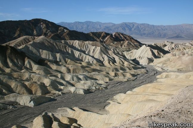
On a trip to Death Valley, I hiked to Zabriskie Point for a panoramic view inside the park. From there I noticed that nearly all of the ground is a smooth mass with individual rocks being nearly non-existent. The most prominent feature is large alluvial fans. At higher elevations nearby, the ground is darker brown while lower down, the ground shows lighter tan and yellow color. I would consider the shape of the fans to determine if the lower yellow ground previously covered the darker browns. Another possibility is that the darker reds are due to oxidation. Determining the mineral types of the different colored soil would be beneficial in figuring out their history. From the shape of the fans tells me what direction the mineral came from, giving me an idea of what existed "upstream" of Zabriskie Point.

Looking west from Zabriskie point shows how sediment flowed to its current position (Smigelski, 2009).

The erosion that created the fans is appears to be from rare rainfalls in which the rain water moved quickly over land, transporting soil with it. The structures might be fairly young geologically speaking and the erosion recent, so searching the area for outcroppings that appear to be older could help determine what the newer alluvium is covering. This may not be possible in the immediate area as it looks like recently moved sediment in every direction!

The flow of sediment created a crazy landscape around Zabiskie Point (Todd, 2011).

Photo References:

Smigelski, S. (2009, November). Zabriskie Point in Death Valley National Park. Hikespeak. https://www.hikespeak.com/attractions/zabriskie-point-in-death-valley/

Todd, C. (2011, May 13). Zabriskie Point in Death Valley. Earth Science Picture of the Day. https://epod.usra.edu/blog/2011/05/zabriskie-point-in-death-valley.html

Week 7- Death Valley- Bridget B Mensah

After my trip to Death Valley, I found this picture that looks exactly like what I was mesmerized by on my stop. Looking at the photo brings up a few different questions. The main one being what types of sediments are in place. I’m guessing that there are metamorphic rocks there also but a geological map would help create an image of the geological events that happened in Death Valley. Being able to see where any faults, bending plates occurred could help piece together the history of Death Valley. Also having different rocks from different regions of the valley would also be helpful.


Photo Credit: Secrant.com

Tuesday, December 1, 2020

Week 7- Death Valley- Jazmine Jones

 In my visit to Death Valley I stopped and  viewed the Golden Canyon which leads to Red Cathedral. When I first saw the picture the first thought that came to my mind was what kind of minerals are these. The way the rocks are shaped it looks like it can be a Feldspar but I could be wrong seeing that I am not able to physically touch the rock. I would want to get a sample of the rock to test it. I would also like to know how old the rocks are and if the mountain rocks in the back are ocean- continent plates or normal faulting.


Wk 6 - Dustin

 Were I to be studying a certain location geologically, I would first request all information on any kind of human intervention and interaction with the area to ensure that I have an accurate picture on anything artificially changed. Next I would examine any current seismic activity to see what is currently happening. Finally, I would get my hands on all recorded natural events so I could try to identify any significant changes or perhaps trends that might align with the current geologic activity. I think with these three pieces of information I could make some educated observations on what I'm studying.

Sunday, November 29, 2020

Week 6: Geological Interpretations - Brandon Thammasine

 I have visited an area between Mammoth Lakes and Long Valley near the eastern edge of California. Upon browsing the California Department of Conservation website, I found a fault activity map of California. After looking at the map, it made me realize that there are numerous faults on the earth's surface. I don't think much about faults but there are a lot more than what I have imagined. 

My screenshot of the current faults that exist between the Mammoth Lakes (left side) and Long Valley (right side). "Fault Activity Map of California," CA.org, State of California, 2020, Fault Activity Map of California

What really stuck out to me was that there was a round fault in this area. Nearly all of the other faults were parallel to each other which may have been caused by the pacific oceanic plate pushing eastward into the U.S continental plate. That is why a lot of plates are similarly parallel to one another. But I am really curious as to why and how this circular fault occurred. 


Week 6- Geological Exposures - William Moran

Joshua Tree National Parks landscape is indescribable and can't be compared to any of the other national parks in the state of California. The San Andreas Fault bounds the South Side of the Park while the Pinto Mountain Fault covers the Northside and smack dab in the middle of the park is the Blue Cut Fault. The use of a seismographic would help determine which of the faults is most active along with the severity of each earthquake in the surrounding area. The website also has maps of mines and mineral resources throughout California which would be helpful while looking at the map of Joshua tree as it was once an area that was mined. You are still able to walk up to the mines and see some of the old rail lines but the mines themselves have had steel bars put in place to block off hikers from going in as they are dangerous and unstable due to how old they are and the fact that three major fault lines cross throughout the park. 

Week 6 - Geological Interpretations - Cory Hall

     When thinking of anything related to geology and natural occurrences of geological processes The San Andreas Fault Line immediately pops to mind. The first piece of information that I would find helpful would be a map of the fault line and the movement of the colliding plates. I feel like this is the most important piece of information related to the fault line and everything that happens in the vicinity. Another tool that would be helpful in studying the area would be a seismograph. I think that  if you're able to tell when tectonic activity is taking place, it would be easier to observe the other surrounding side effects. The final piece of information I would like would be regional CO2 emission reports. I know the ideas surrounding global warming are relatively new, but I think it would be neat to see if there's any correlation between the oceans heating up and activity within the fault itself.


© David Lynch


Journal #6 Geological interpretation, Ricardo Aguilar


Journal week #6


In my case I decided to make questions regarding two different geological areas and geological resources and the California Department of conservation itself. This regarding its role in activities that impact this states geological landscape transformation. Thus, aspects I believe are directly related to geological alterations in such a seismologic zone as the San Francisco area and the many valleys surrounding this state. for example, in terms of states oil and gas wells, in terms of oil and gas excavations, I found that the department of conservation is very strict in terms of permitting the drilling, gas and oil extraction due to the geological zone that he valley of San Fernando and San Francisco represents for the population living in that area. I was also curios over the mines and mineral extraction or mining in zones near some seismologic areas, I found that for this matter the department of conservation subjects to strict geological investigation for assessing and determining the zones for mineral and mineral mining which is very important for the geological zones in terms  of  environmental impact. They are concerned that some geological alterations in this zone might signify geological land alteration. lastly, I fond very interesting for the land use and planning the department of conservation intervenes in every geological zone of this State of California my question regarding this department would be how do this department informs to the public how to locate the wells and mining sites. This a publication issue with in this institution.


 The California Department of Conservation, Geologic Energy Managment Division publishes a GIS feature class of well locations and its associated records across the state for use by the public.

Geological Interpretations - Tyler Osterberg

 For this week's blog post I am visiting McArthur-Burney Falls Memorial State Park.


My geological interpretations would be requested for fault activity, landslide inventory, and the corresponding geological map.  The first and second would give active geological changes in the area I have chosen.  These would give us new cross-sections of strata that we can record.  Comparing these records with the geological map that we requested third would be used to make updates to the geological map.

Photograph screenshot from https://www.conservation.ca.gov/cgs/Documents/Publications/Special-Reports/SR_230-GeoGems-Notes-LR/CGS_SR230_McArthurBurneyFalls_MemorialSP_lr.pdf

Week 6 - Geological Interpretations - Travis Suggitt

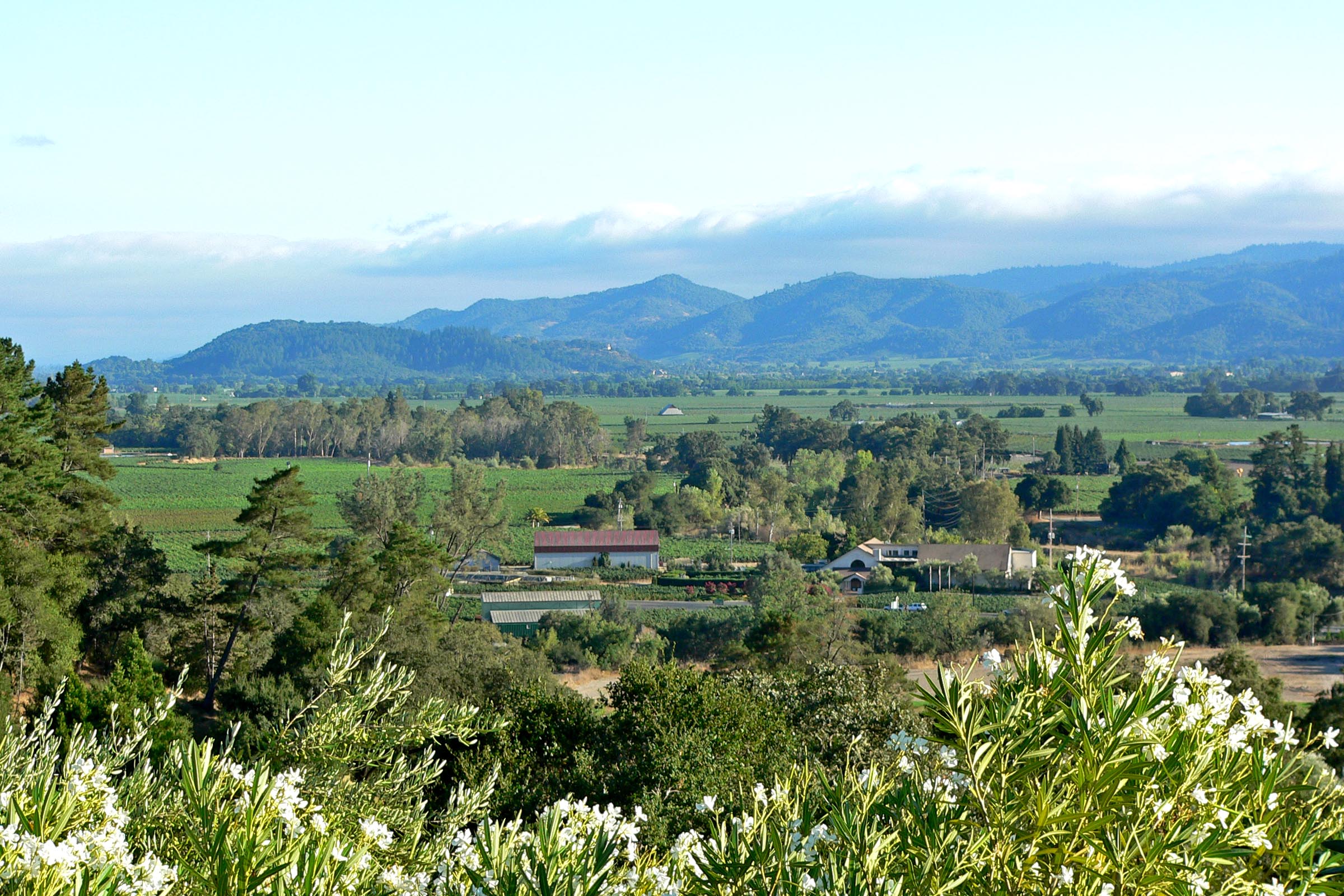
In the region area that splits Sonoma Valley to the west from Napa Valley to the east, minerals from a wide range of periods are found. The mountains are mostly volcanic rocks from the tertiary period with older Quaternary alluvium found in the lower elevations such as the valley floors and younger Cretaceous period minerals on the western edge of Napa Valley. Radiometric dating from various places would likely confirm the geological map.

Sonoma Mountains viewed from across Napa valley (Shebs, 2005)

In areas where the Sonoma mountains meet valley floors on either side, the Geological map shows several distinct groups of Quaternary alluvium that are dated younger than the Quaternary alluvium of the valley floors. Using information on the location of mountain creeks, one could determine if these are alluvial fans which formed which carried sediment to the floor from higher elevations.

In the furthest south portion of this area (just north of the bay), a blob of Quaternary volcanic rock is seen. Comparing the blob to a topological map indicates that this is a high point named Sears Point. Since the rocks that surround it are of a younger volcanic origin and considering the principle of superposition, we could determine that there is more Quaternary rock from this formation covered by the later volcanic rocks.

Photo reference:

Shebs, S. (2005, September). File:Napa Valley from Auberge du Soleil 1.jpg in Wikimedia Commons. https://commons.wikimedia.org/wiki/File:Napa_Valley_from_Auberge_du_Soleil_1.jpg

Week 6 Geological Interpretations-Hirra Faizi

 While searching through the California Department of Conversation's website, I came across the link for tsunamis. In brief, a tsunami is a series of waves which results from the occurrence of an earthquake, landslide, volcanic eruption, or a large meteor hitting the ocean. In terms of an earthquake, when they occur they cause a large movement of the sea floor which goes upward and results in the rise of water. Tsunamis can travel around 500 mph across the open ocean but slow down to about 30 mph as it approaches land. For an area prone to tsunamis, there are warning signs to help prepare for it. One of the most noticeable signs is the rapid receding of ocean water before the first wave of the tsunami hits. It's also important to note that not all earthquakes have resulted in a tsunami but in prone areas it is wise to be on the lookout so you can safely evacuate. In addition, there has been a tsunami preparedness brochure for boaters. This is because tsunamis in the state had caused about $100 million in damage to the maritime community. Furthermore, the California Geological Survey (CGS) provides us with geologic and seismic expertise to the public and works with the government to make statewide tsunami inundation maps and preparedness for the state. This website provides the state of California's residents with more than enough information regarding the history of the complex geology there as well as essential information on how to prepare for natural disasters. 

                                                                    California Tsunami


                                                                californiaeqclearinghouse.org

Week 6 Geological Exposures - Joshua Rosson


                                                    (Photo credit: Bob Wick)

I chose the Mojave Desert as my region. The first piece of data that I would request is the map of fault lines that the Department of Conservation provides. The reason this is so important is due to the explanation that it can provide for the various volcanic eruptions that have occurred in during the formation of the Mojave. Across the desert there are several cinder cones pointing towards the Mojave being located near several faults. Next I would request the historical data of the water table. This is due to the soda lakes showing evidence of water quickly evaporating in an arid climate with no way to the sea, leading me to believe that the coast of California was once more inland than it is now. Finally I would ask for a topographical map. This combined with the fault line data can show evidence of plates that are colliding and being raised which would explain the Mojave's formation into a arid desert.

Sources:

Logan, M. (2019, July 30). How We Defeated a Corporate Scheme to Sell the Mojave Desert's Water. Retrieved November 29, 2020, from https://earthjustice.org/blog/2018-november/we-re-fighting-a-corporate-scheme-to-sell-the-mojave-desert-s-water

Week 6- El Capitan

 El Capitan, Yosemite National Park, United States

The image above displays El Capitan, located in Yosemite National Park. El Capitan is the largest monolith of granite in the world. The collision of tectonic plates caused its formation some 220 million years ago. There are a number of different types of granite rocks on the face of El Cap, however they were all formed from the heating of the magna under the surface from the collision of the plates. Glaciers then carved through and created the valley floor 3 million years ago, putting the final touches on the mountain. This is an absolutely astonishing geological formation and attracts many experienced rock climbers every year. 

Week 6 - Santa Monica Mountains


The Santa Monica Mountains stretch northwest of Santa Monica and Los Angeles down the coasts of California, east to west. With a broad number of minerals, including marine and non-marine sedimentary rocks and volcanic ash, the mountains are diverse in their geology. In addition, there are a huge number of folds and a collection of fossils in the field. The mountains are now starting to shift sitting near active faults. The mountains are not as old as others. Most of the rocks are from the Tertiary and Quaternary period, with most less than 20 million years old which is pretty young.


References

[Digital image]. (n.d.). Retrieved from https://www.nps.gov/im/images/5CA33EC9-9570-0AFF-CCC23752592132B7HiResProxy.jpg?maxwidth=650&autorotate=false


Saturday, November 28, 2020

Week 6 - Geological Interpretations - James Cebry


In researching the California Department of Conservation website, I found a page on Landslide.  When I lived in California this was something that had affected me, so I found it interesting.  I found that there are several different categories of landslides that include: earth flows, debris flows, debris slides, rockslides, and rock falls.  The different categories depend on if it is only soil or rock or a combination of the two.  An earth flow is a specific type of flow where the majority of the soil material is fine-grain silt and clay.  A debris flow is where the soil is a majority coarse-grained material from sand to boulder size particles.  A debris slide is similar to a debris flow but is generally on a steeper slope and carry more power.  A rockslide is a landslide that involves bedrock that move and remain largely intact.  A rock fall is where a massive rock detaches from a steep slope and descends mainly through the air.

Landslide can be a big problem in many areas of California because it causes damage to houses, roads, and other structures.  Landslides become a big problem when the rain season comes.  Most of the year California is very dry and does not receive much rain fall.  This makes many areas have dry and brittle vegetation.  With the combination of Santa Ann winds in the south or Diablo winds in the north that bring hot dry air from the desert into the coastal regains.  This creates very good conditions for wildfires which burn all of the vegetation from the mountain sides.  Once most of the vegetation is burnt away there is nothing to hold the soil on the mountain sides.  The next time there is heavy rain it creates landslides.

Map of Resent Landslides


Friday, November 27, 2020

Week 6- Geological Interpretations-Bridget B. Mensah

While searching through conservation.ca.gov a picture of the King City Asbestos Corporation Mine (KCAC mine) back in 1998 caught my eye. I was going through the hazards tabs when I came across a map of California that detailed hazardous minerals.

The mine opened back in 1992 but closed in 2002, it was the last chrysotile asbestos operating mine when they shut down. Scientist began to realize that "asbestos was a major cause of various diseases including lung cancer, mesothelioma and a scarring of the lungs that was given the name “asbestosis”. Use of asbestos declined rapidly, with many countries banning the substance, and extensive efforts made to remove asbestos from buildings." (Bustmold.com) With those dangers in mind, it was then estimated that about 40-50% of the mine was made out of chrysotile asbestos, so you can imagine how dangerous working in mines like KCAC was. In 1906 the very first death of an asbestos worker was recorded, he died from pulmonary failure. The autopsy found showed a large number of asbestos fibers in his lungs. 

While going through conservation.ca.gov I realized just how many geological complexities there truly are. I also learned that the San Andres fault isn't California's only problem. 


This is the 1998 picture that I was referring to. (Photo Credit: conservation.ca.gov)


Week 6- Geological Interpretations-Tim Pester

 While searching threw the California Department of Conservations website, I came across the link for Geologic Hazards. I found this link to be interesting because it helped to summarize the last four weeks of learning in this class. From seismic hazards like earthquakes to other hazards like landslides or minerals like radon and mercury to volcanic hazards that being monitored by experts. In the section of earthquake, it went into more detail about how tectonic plates moving against each other keep the lands of California unstable. While scientists are using programs like The California Strong Motion Instrumentation Program (CSMIP) to record the energy being created by these plates as well during earthquakes to help assist in emergency planning and action (California, 2019).

 The next link I saw on the website is Tsunami Preparedness. I don’t know why, but always had an interest in how tidal waves were created. From the article, I learned that California has active offshore faults and unstable submarine slopes that can increase tsunami activity near the coast. While, I understood that earthquakes cause tidal waves, with the energy they create, I was unaware that other factors like slopes increase the likelihood of a giant wave (California, Tsunami Preparedness, 2019).


A map of the San Andreas Fault line and Pacific Plate. And how the North America Plate and Pacific Plate are brushing up against one another to create the uneasiness in the region.


Works Cited

California, S. o. (2019). Geologic Hazards. Retrieved from California Department of Conservation: https://www.conservation.ca.gov/cgs/geohazards

California, S. o. (2019). Tsunami Preparedness. Retrieved from California Department of Conservation: https://www.conservation.ca.gov/cgs/tsunami/preparedness

Week 6 Geological Interpretations -- Robbie Todd II

 When searching around I found the fault evaluation for Mount Baldy to be very useful.  I used to live in the area and I found it exciting to find out what was going on under our feet.  It is amazing how much activity is happening in the area.  I was also able find an earthquake map for the area as well.  This is really neat as I only lived a few 100 yards from the San Andreas fault line.  I am surprised I didn't feel more movement and earthquakes while living there.  Even though I did not live next to the coast, the tsunami map was very useful.  I didn't realize how many people would be affected and live within a tsunami warning area.  These are the few maps I found useful during my study.  The reason for this is I still have friends that live in these areas and are affected if a natural disaster happens.


Robbie


Reference

California, S. O. (n.d.). Department of conservation map server. DOC Maps. Retrieved November 27, 2020, from https://maps.conservation.ca.gov

Thursday, November 26, 2020

Week 6- Volcano watch using Hawaiian eruptions to understand Volcansim

 When I went to visit the map site for California this stood out to me the most. There are currently 5 volcanos being observed from high to low threats currently in California. This information was released recently on November 12th 2020. So far the information that they have is not old enough to determine how or when the Volcanos will erupt. It has caused a dilemma for the geologist to know in the future when they will erupt; because the magmas from different regions erupt in different ways, it was stated that next eruptions can range from days, weeks, months, years or several decades. California,  has the classic-looking mountainous stratovolcano of Mount Shasta and the large caldera of Long Valley, but neither has erupted historically though each has evidence of geologically young activity. The most recent eruption in California was from 1914–1917 at Lassen Peak, creating a lava dome and related ash deposit, in what is now Lassen Volcanic National Park. An area east of Mount Shasta and Lassen Peak is relatively flat but contains ‘young-looking’ lava flows.

They also presented the statuses of the volcanos they are watching,  Kīlauea and Mauna Loa, Brushy Butte none of these have erupted as of yet. My questions for this experiment is 1. Why is this information important, what do they plan on doing with the information found. 2. Most of the volcanos havent erupted in nearly 20 years are they using anything special to expediate it? 3. When and if the volcanos do erupt how would that affect the plants and creatures around it?


 (https://www.usgs.gov/natural-hazards/volcano-hazards/about-alert-levels). Kīlauea updates are issued monthly.