Tuesday, March 31, 2020

Evan Lieberman Week 4 Volcanoes

DeLorean Time Machine
Photo Credit: https://www.deloreantimemachine.com/

For my volcano field trip today, I chose to explore one of the most extreme volcanic events to occur in the continental United States, the site of Mt. St.Helens.  To begin, I jumped in my handy time machine, and went back to 1980 to observe the volcano in it's pre-eruptive state.  (And yes I'm aware that the film my time machine is based on called Back to the Future, actually now takes place in the past).

As I set the dials for my flux capacitor to 1980, I emerged from the time travel tunnels in Skamania County Washington.  


Pre-eruption Photo Credit: Pinterest
Pictured to the left is an image of Mt.St.Helens prior to it's eruption.  What we see here is is a prime example of a composite volcano or stratovolcano.  A composite(stratovolcano) volcano is defined by it's external appearance, they tend to elevate high above sea level, and have a viscous composition internally.  As a result of the viscosity of their inner composition, their eruptions tend to be thick, viscous, and travel relatively short distances.  Unfortunately, due to this same composition, these volcanoes can also have violent pyroclastic eruptions, due to the thickness trapping gasses and violently propelling pyrolclastic ash, rocks, or bombs hundreds or thousands of feet from the eruption site.  The volcanic activity associated with this particular volcano is mainly due to subduction occuring where the Juan De Fuca plate subducts beneath the North American Plate.


Digital Elevation Map of Mount St. Helens with annotation of pre-1980 topography and deposits from 1980 - 2008.
 (Click image to view full size.)
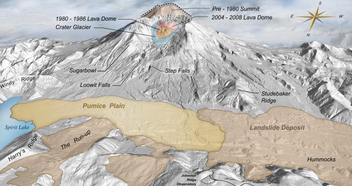
Digital Elevation Map of Mount St. Helens  pre-1980 topography and deposits from 1980 - 2008[Credit USGS]
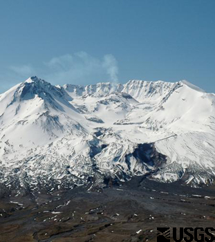
I decided to spend some time in the 1980s drinking TAB, and purchasing stock in Apple, and then returned to the site (safely distant) on May 18, 1980.  What occurred at this site was an example of an explosive volcanic eruption.  In the wake of the eruption, the USGS has analyzed the contents of the eruptive material and concludes:"substantial amounts of basalt and andesite began to erupt as lava flows between phases of dacite eruptive activity. These lava flows buried large parts of a central cluster of dacite domes and flanking fans, which started the cone building in earnest [USGS]".  Essentially, the viscous basaltic and andesitic lava flows sealed all the volcanic vents, pressurizing the contents in the magma chamber.  This caused extreme pressure to build literally blowing the top off of the volcano and sending ash and other pyroclastic materials for thousands of km.  To compare here is an image of the volcano post-eruption (taken from my camera on May 19, 1980...but really from the USGS).
Photo Credit USGS

In the post eruptive state, nearly 1300 feet of the mountain's top portion was entirely removed, and ejected thousands of kms.  The sheer force of the explosion also leveled trees, property, and pretty much anything in it's path.  

In the wake of the destruction of this event, the next question on most people's minds would be, can this happen again?  The answer to that questions is two-fold, will the volcano erupt again?  Yes, I set the dial to my time machine to January 16, 2008 and observed another eruption.  This one was not explosive, but a minor eruption.  Scientists have ceased close activity to the dome, as pressure and dome formation continues into today.  It is likely, we will see another eruption of Mt.St.Helens as it is  located in subduction zone.  It is unlikely that in our lifetimes we will see another explosive eruption on the scale of the 1980 event, as the formation and building of pressure took thousands of years.  But it would be expected that an eruption on a smaller scale may well occur in the near future.  Unfortunately I have been unable to secure enough fuel in my time machine to investigate into the future.  

After my time-hopping was concluded, I returned my time machine to March 31st 2020, and resumed appropriate social distancing. 

Monday, March 30, 2020

Week 4 - Volcanoes - Ryan Klassy

(Click to enlarge photos)


Mount Shishaldin - Source: photovolcanica.com

Mount Shishaldin is a volcano located in the Aleutian Islands, just off the coast of Alaska. The volcano is still an active volcano and has had eruptions as recently as January of 2020! Mount Shishaldin has the highest peak of any of the Aleutian Island volcanoes. The volcano is considered a stratovolcano, also known as a composite volcano, meaning that it is built up of many alternating layers of lava that has hardened along with pyroclastic debris and other sedimentary layers.


Melted view - Source: Google Earth
As you can see from the photo above, it is covered in snow and the top 6,600 feet are actually capped in glacial ice. I thought it was interesting to think that a volcano that still has active eruptions could still be covered in ice and snow. I was able to get a screenshot from Google Earth (on the right) that had different satellite images stitched together that were obviously taken at different times of the year. I took the screenshot because it was a great way to show the difference in the snow levels over the year.


Aerial view - Source: Google Earth
The location of the volcano itself can be better seen in the photo to the left. It is about a third of the way down the Aleutian chain. This chain of volcanic islands was formed by the subduction of the Pacific plate underneath the North American plate. As the oceanic plate is subdued, it enters the mantle and begins to melt. This less dense magma floats up towards the surface where it creates islands and volcanoes.


Eruption view - Source: USGS

The photo on the right shows part of the January 2020 eruption of Mount Shishaldin. You can see in the image that there is mostly gas and ash (lighter particles) rising from the volcano. In order to get the more heavy lapilli, and even heavier blocks and bombs, we would need a more explosive force to lift them into the air. During the initial eruption there were small amounts of these materials, but the majority of the eruption was gas and ash.


The two photos below are from the USGS and show the lava flowing down the side of the volcano during it's January 2020 eruption. This lava is what will form part of this stratovolcano's extrusive igneous layers. The other layers will fill with sediments over time. This lava will cool before it gets very far which is what gives Mount Shishaldin it's steep sided walls.

Lava view - Source: USGS 
Lava view - Source: USGS

Although Mount Shishaldin is a mildly active volcano, it still comes with it's own set of hazards. Even with slowly flowing lava from mild eruptions, there are still dangers to anyone on the mountain. Locals and researchers are both known to climb this mountain both for research and for recreation. If anyone is on the mountain during an eruption they could be injured or killed. It is important that people check the USGS site for warnings regarding the activity of the mountain. 

Since this is an active volcano, the chances of it erupting in the future are almost certain. The most recent eruption was only a few months ago. Although they are not large explosive eruptions, care still must be taken.

Sunday, March 29, 2020

 
Week 3 - Weathering and Erosion
 
Deserts - Great Sand Dunes National Park & Preserve in Colorado


The Great Sand Dunes National Park & Preserve have been intriguing to me for a few years now. I am hoping to visit there soon. They are mounds and ridges of sand formed by wind. They are made from sediment and loess. Loess is windblown silt that comes from deserts or areas that have been glaciated. Dunes form or take their shape when wind blows sand up a slope then the sand settles to form the slope.


Week 3 Johns Hopkins Glacier

Johns Hopkins Glacier


Alaska has numerous stunning glaciers throughout the state.  I have seen pictures and heard stories from family and friends who have experienced these amazing sites themselves and I am very jealous.  One of my favorite spots Glacier Bay National Park. 

Glacier Bay National Park is home to 1,045 glaciers in the park covering 2,055 square miles.  My must experience glacier is The Johns Hopkins Glacier.  The Johns Hopkins Glacier is 12 miles long with the only access to the face of the stunning glacier from the Johns Hopkins Inlet.  This is a tidewater glacier is a glacier that stops at the sea or ocean.  The tidewater glacier cycle that created these beautiful ice creations occurs over centuries of repetitive actions of advanced quick alternating with quick withdrawal of water followed by a period of quiet. It’s an amazing creation from Mother Earth.  


Credits: Peggy Reimchen , Family Friend.

Reimchen, Peggy. “Panoramic View of Johns Hopkins Glacier with Mount Orville and Mount Wilbur in the Background (1of2).” Flickr, Yahoo!, 20 May 2015, www.flickr.com/photos/artsylens/17701405820.


Week 3 - Chain O' Lakes (Indiana) - Kyle Quirk

This week I decided to visit my home state of Indiana, specifically the Chain O' Lakes State Park in the northeastern part of the state in Noble County.  The northern two-thirds of Indiana was shaped by glaciers formed in Canada during the Pleistocene Epoch, specifically from 19,000 to 16,000 years ago.

As the name suggest, Chain O' Lakes State Park consists of eleven lakes in total with eight of them interconnected.  Formed by retreating glaciers, these lakes are known as kettle lakes, which also formed the bogs and rolling hills of the park and northern Indiana.


Map provided by visitindiana.com
Perennial snowpack during Pleistocene Epoch became so thick in this area that it formed continental glaciers that began to flow plastically under their own weight and away from where the great snow accumulation occurred.  The glacier flowed outward centered over present-day Hudson Bay.  Part of this glacier called the Laurentide Ice Sheet and subdivided into ice lobs due to the topography and mechanics of ice flow.  Chain O' Lakes Sate Park was most affected by the Saginaw and Huron-Erie Lobs of this sheet.

The glaciers that formed over the midwest were not always advancing, over the years they experienced warm and cold periods, causing the glacier to retreat and then advance.  In the decay of these ice sheets, sediments and land forms from other regions were left behind. This material was either outwash, sorted sand and gravel; and some was known as till, which is mixed sand, silt, boulders, and clay.  Both outwash and till deposits can be found throughout the park.

The Chain O' Lakes was formed during the meltdown of the Erie Lobe.  As the ice melted, as a result of flow stresses in the glacier, fractures became enlarged with meltwater and allowed sediment-laden streams to flow through and below the ice mass.  Till is deposited by a variety of mechanisms, around Chain O' Lakes the variety of till there is called ablation till.  This consists of sediments that were carried by the Erie Lobe as it was advancing.  

It's truly amazing what a glacier can do to the topography of a region, but even more impressive is just how much till and outwash they can leave behind.  The kettle lakes at Chain O' Lakes State Park is a great example of the power glaciers can have and something that can still be witnessed to this day.


A waterway between Sand and Bowen lakes, picture provided by visitindiana.com

Week 3 Svartisen

I decided to visit Norway this week to see a glacier called Svartisen. Svartisen is known as the second largest glacier in Norway with 60 glacier tongues. A glacier tongue is a long sheet of ice projecting out the ground. Before anything else i took in the scenery as it seemed quite peaceful. It turns out that there are actually two glaciers present in Nordland county. The summer months usually see more visitors than any other time. The melting of the glacier has accelerated over the years and there is no telling how long it will be able to survive according to some scientists.
Path up to main viewpoint Svartisen Engabreen glacier

Week 3 - Grinnell Glacier - Matt Bulow

This week I ventured out to Glacier National Park in Montana. There I trekked out to see the Grinnell Glacier which happens to be one of the most photographed glaciers in the park. There are photos of Grinnell that date back to the 1850s! The Grinnell Glacier is a mountain glacier. A mountain glacier is basically a glacier that forms in the mountains and fills a mountain valley. In 1850, the Grinnell Glacier measured to be 710 acres. Unfortunately, since then the glacier has been shrinking at a considerable rate. In 2005 it was measured to only be 152 acres. Like most glaciers in the park, they have been given a worst case scenario to be completely melted by the year 2030 due to carbon emissions. I certainly hope that the projections are wrong and these marvels of beauty will continue to be around for years to come.
Hiking Grinnell Glacier Trail, Glacier National Park, Montana, USA ...

Week 3 Sahara Desert - Tracey Peterson


This week, my travels take me to city of Cairo in Egypt, on the edge of the Sahara Desert. The Sahara is the largest hot desert and third largest overall on the planet; only the Antarctic and Arctic are larger. My journey to this desert took me within 500 miles of the Tropic of Cancer, which runs East-West through nearly the middle of the Sahara. This location means that the Sahara was formed, primarily, due to sub-tropical equatorial air currents.
Eastern Sahara
The Sahara is approximately 3.6 Million square miles, ranging from the sand dunes commonly associated with deserts to more rocky areas with sparse vegetation. The annual precipitation varies between the north and south fringes and the central region. Rainfall in the north, along the Mediterranean Sea, ranges from 4-10 inches. In the central Saharan, the average rainfall varies between less than 1 millimeter to as much 20 millimeters.
Galuzzi, Luca, Apr 7 2007, [photograph]
The Sahara is the most well-known desert on Earth, but not the driest, largest, or oldest. It's central dunes have been used for photographs, movies, and scientific research. In addition, tribes of nomadic peoples have lived in various regions of the desert for centuries and will continue to inhabit this inhospitable region of the globe.

Week 3 - Vatnajökull Glacier - Jacob Norenko

This week I decided to make my way to Iceland to visit the biggest glacier in all of Europe, Vatnajökull! In fact many people may have seen this glacier before without even knowing it because it is used in media such as Game of Thrones and Batman. Vatnajökull is classified as an ice cap glacier. They are very similar to ice sheets but tend to be smaller. Vatnajökull, however, still covers 8% of Iceland. This glacier creates many alpine outlet glaciers which flow down the valleys of Vatnajökull, and with it debris and sediment as well. The valleys are very wide, due to the erosion created by the glacier or possibly volcanic activity that exists there. Unfortunatley due to climate change Vatnajökull is shrinking, and future generations may not get to experience this icy wonder as we have.
Vatnajökull | Guide to Iceland
 Guide to Iceland. (n.d.). Retrieved March 28, 2020, from https://guidetoiceland.is/travel-iceland/drive/vatnajokull
In 2014 I deployed to Qatar, which is a small country and a part of the Saudi Arabian Peninsula. I've actually had a lot of exposure to desert since then, which is rather interesting. I changed duty stations in 2015 to Las Vegas, Nevada, where I stayed for three and a half years before being reassigned to Colorado Springs. I've driven through Arizona a few times, and I have to say that Arizona is BY FAR the prettiest desert I have seen out of my three locations. It has more rock formations and the stereotypical cactus you might think of when you think of the desert. Unfortuantely, I can't seem to locate any of my photos of Las Vegas or Arizona- I'd have

This picture is a sunset at Qatar:


It is perhaps difficult to tell from a photo of overcast, but it was typically hazy in the distance. One of the reasons the desert is so hazy due to the humidity. I can tell you, having been born and raised in Florida, I have never felt a place so hot and so humid as I did in Qatar. It is also located relatively close to the equator, appearing to be a little further south (towards the equator) than Florida.

You'll also notice a large number of rocks in this photo. Qatar actually seemed to be the least rocky of the three deserts. Arizona had natural rock formations (not to mention the Grand Canyon), and Vegas had some mountains. But even in this photo, you see how many rocks there are. The rocks are formed by sand erosion, typically by wind (but can also be by water), which accumulates to form rocks. Because of this, deserts are typically very rocky, whether they are flat or mountainous.

Week 3 - Columbia River - David Clark


After last weeks adventure down south, to Joshua Tree, I wanted to visit a landmark a little closer to home. Being in quarantine still, a quick hop down south is just what the Dr. ordered (not literally of course). The Columbia River is just to my south, about 60 miles. When you hit the Columbia, you can go east following the river on highway 14 to visit the beautiful Columbia River Gorge. This is where I went, and for this trip I brought along my dog, Bo.

As Bo began to sniff around, he looked at the river with delight in his eyes, he wanted to go for a swim! I told him to hold on, the river looks beautiful and refreshing, but may not be a good river for swimming. He looked back at me, wondering why I was holding his leash so tight. "Let me explain bud." I told him. "Because this is the only river that cuts through the Cascade mountains, it is the only source for the drainage basins east of the mountains." "Also, because it is cutting a path through the mountains, the type of channel is a bedrock channel." Bo looked back, still not understanding. "This means that the water velocity and discharge is very high, it is moving fast!" He was still not impressed, certain his strong Mastiff limbs would proper him through the water. "Why do you think they built all those dams on the river Bo? High velocity makes for an excellent dam." "In fact, in the past glaciers used to dam the river naturally, creating ice dams."

He begrudgingly accepted my explanation, and we sat down to watch the river a bit. "See how clean the water is bud?" I asked. "This is because the river bed is so hard. The river cannot pick up fine sediment and transport it as bed load." "Instead, the river uses quarrying, abrasion, and corrosion over long periods of time. The lack of loose sediment is why the river is so clear! You could say the river has very high capacity and competence." "See how high the valley walls are? That is because the river has been down cutting for millions of years!" "See those level spots on the valley walls? Those are called terraces, where the river once ran". Bo licked his paw, which he then used to scratch his jowels. "Agreed bud, very impressive!"

We hopped back into the car, and started headed back west, toward I5 which goes north. As we hit I5, I explained to Bo that down further is where the Columbia dumps into the Pacific ocean. "Think of it bud, this is where all sediment deposition happens!" "You see how the river slows down? This is because it's velocity is slowing as it hits the Pacific." Bo looked at me, obviously wanted to know about the drainage patterns. "Good question bud, the Columbia spreads out into a dendritic pattern, with little inlets near Ilwaco and Long Beach." As we headed north on I5, Bo and I were silent, daydreaming about gradient levels and discharge.

Week 3 - Amazon River - Jeremy Haynes

This week, my wife and I decided to visit the Amazon River at it's mouth located in Macapa, Brazil. During this, we took a helicopter tour of the river in its' entire length of 3,977 miles. Once in the air, it was notable how the shape of the valley occupied by the Amazon River begins in the Andes Mountains and then runs into mostly flat lands that make it prone to flooding. The tour guide stated that not all parts of the Amazon River floods at the same time. Many of its' branches will flood at different parts of the year. With its' annual flooding during high tide of winter, the water from the Atlantic is funneled into the Amazon delta in which results in a tidal bore so powerful that it extends upstream and within the River for hundreds of miles. During our tour you could look down and see the various meandering paths that the River has taken over the years. Multiple oxbow's show how the River has created a shorter path to other parts of the River and inevitably cut of the remainder path leaving behind a small body of water that will eventually dry up. My wife asked the tour guide why the River creates these different shapes and he stated that the River meanders due to the flatness of the basin as well as the force of the water that crashes into the far side of the River after a curve. Considering the Amazon River's color and nature reflects how it carries high amounts of sediment in its' suspended load, the 7KPH or 4.35MPH speeds that River can reach up to, meandering is extremely likely. This is also due to the fact that the River is perennial in nature considering its' flow is constant in a majority of its' stream beds. Though, as the guide pointed out, the Amazon River is vast and there are intermittent streams at various altitudes that stops flow in dry periods during the year. This was definitely an interesting tour and considering the Amazon is known for its' creepy spiders and Anaconda's, I made this journey a rather quick one!

 The Amazon rainforest is the world’s largest tropical rainforest, famed for its biodiversity and animal life

Image [Above] Source: (Lock, 2019)

References:

Lock, S. (28 Aug. 2019). AMAZING AMAZON Where is the Amazon rainforest, how long has it been around and what exotic animals call it home? Retrieved 27 Mar. 2020 from: https://www.thesun.co.uk/news/9790130/where-amazon-rainforest-animals-plants/.

Week 3_Deserts_Michael Bluett

I would love to travel more, but of course with all these travel precautions going on, I will have to bring up a memory. In 2016 I had the opportunity to be deployed in the country of Qatar. The country is a flat desert peninsula north of Saudi Arabia.


The climate there was extremely hot and humid from the Summer months that I arrived there to the Winter months when I left. While I was there, we did witness a massive sandstorm. I remember waking up one afternoon and the sun was getting blocked. A wall of sand, presumably sediment, appeared to reach as far as the heavens. Unfortunately I didn’t take any pictures because I was stuck in shock. These winds come in from the Persian gulf. Due to the high humidity in the area, there was also a lot of fog. Some days while I was working, I could barely see around me.


Saturday, March 28, 2020

Week 3 - Glaciers - Robbie Ficalora

In May of 2019, my fiancé and I traveled to Iceland with her family. On the trip we made our way to Jökulsárlón Glacier Lagoon.
Panorama of Jökulsárlón Glacier Lagoon
The Lagoon has been formed from the melting receding glacial ice from the Breiðamerkurjökull glacier. The originating glacier is from a much larger icecap of a continental glacier. As the glacier melts into the lake, it deposits icebergs as shown in the photo.
Jökulsárlón Black Sand Beach
An interesting note about the area is that as the lake flows out to meet the waters of the Atlantic Ocean, it carries smaller chunks of ice with it "around the corner" to a black sand beach also referred to as "Diamond Beach" due to the contrast of glinting ice on top of the silty volcanic sand.
This ice contains rocks from the glacier source of origin as can be seen by the smooth rocks that do not match that of the black sand.
Once our time was concluded at the beach, we hoped back in the bus of a van I was driving and head back to our Air BnB, all while looking at parts of the country side, "Does that look like a place in 'Game of Thrones'?"

C. Campbell_Week 3_The Allegheny River: A Story of My Backyard

The Allegheny River: A Story of My Backyard

This week I headed out my back door and down to the Allegheny River banks! I am fortunate to live not in the floodplain of the Allegheny River, but just overlooking it, making for many majestic sights. These two photos were taken one foggy morning from our back deck...I am spoiled with my view I admit. BUT it has also given me great appreciation for the many gifts and strengths of our river system. My family and I spend significant time on the rivers living in Pittsburgh, so this was a nice opportunity to learn more about my backyard! 
 In 2018, rains poured over our little community creating a discharge of monumental proportions, pouring the river over its levees onto the flood plains. The local community main street was devastated and tragically some lost their lives. It hit at rush hour so there were maximum people on our roadways. It seems odd that on top of a mountain where Pittsburgh sits, we could experience flooding, but it happened in my lifetime! I might not otherwise have believed it. 

Verona Borough
Interestingly I learned that the Allegheny River is over 300 miles in length. Beginning in north central Pennsylvania and flowing north into southeastern New York, the Allegheny turns again and flows south through southwestern Pennsylvania. It is a tributary to the Ohio and Mississippi Rivers and eventually helps to deposit sediment into the Gulf of Mexico. In 2017 it was voted River of the Year for its biological diversity, part of which contains the largest deposit of fresh water mussels in the US! It also has over 350 acres of protected islands and 80 miles are designated National Wild and Scenic River offering it greater protection to development than other rivers. 


Our waters used to be more polluted, but the clean water acts passed in the last few decades have contributed to cleaner waters and fresh food supplies bringing the eagles back to our area for the first time in a lifetime! 
Just like its meandering path, the Allegheny River has a meandering past. During the sixteenth century, control of the river was passed back and forth between two local Native tribes, the Shawnee and the Iroquois. Eventually during the French invasion, the Shawnee as the current controlling tribe entered into an alliance with the French to defend against the British incursion. This lead to the French and Indian War in the 1750s. In the early 1760s when the British gained control of the area through the Treaty of Paris, the pressure to open the area to white settlement, experts say, became one of the root causes of the Revolutionary War. 
Harmar Egale's Nest


Finally, as shown in the picture below, the Allegheny River (left) and the Monongahela River (right) join to form the Ohio River. The Ohio River then flows over 980 miles through to Illinois where it joins the Mississippi. All of these great rivers carry sediment through their currents to the edge of the ocean in the Gulf of Mexico. It's so bizarre to think that the pebble I tossed into the river last week on my visit to the river banks might find its way to the Gulf of Mexico next month. 


Friday, March 27, 2020

The Animas River - Jacob Fisher


This week I traveled to the Animas River, a perennial flow, in southeastern Colorado. The river’s headwaters are in the mountains above Silverton Colorado and drains south into the San Juan River in northern New Mexico.
Animas River near Durango CO [PHOTO: Jerry McBride/Durango Herald https://durangoherald.com/articles/243752]
 
The flow rate of the Animas varies greatly between seasons, its minimum flow occurs during the winter and the greatest flow occurring in the spring from snowmelt. There is occasional late summer and early fall floods with the worst on record being October 5, 1911.
 
Flooded footbridge over the Animas River Oct 5, 1911 [PHOTO: Center of Southwest Studies]

From the river’s headwaters to Baker’s Bridge, north of Durango Colorado, the Animas gradient varies from steep to moderate. The upper section of the Animas is composed of high altitude narrow canyons, formed when glaciers carved through the Precambrian formations, while in the valley below Baker’s Bridge, it slows and meanders back and forth creating oxbows. From start to finish the Animas drops 7,000 feet.