Sunday, March 31, 2019

Week 3- Colorado Desert

A desert is a region where little precipitation occurs and living conditions are hostile for plants and animals. Deserts cover about one fifth of the earths surface. Deserts are part of a wider class of regions called dry lands. These areas exist under a moisture deficit, which means they frequently lose more moisture through evaporation than they receive from annual precipitation. 
Image result for colorado desert
The Colorado Desert is part of the Sonoran Desert. It extends from southeastward for 164 miles from the San Gorgonio pass in southeastern California, to the Colorado River delta in northern Mexico. The climate in the Colorado Desert is different from other deserts because the region experiences greater summer daytime temperatures than higher-elevation deserts and almost never experiences frost. The Colorado desert typically experiences two rainy seasons per year, in the winter and late summer. This regions geology is dominated by the transition of the tectonic plate boundary from rift to fault. This area is subjected to earthquakes, and the crust is being stretched which will cause sinking of the terrain over time. 

Week 3 - Glaciers - Valero

A glacier is a very slowly moving river of ice, in which the snow in the glacier accumulation area accumulates quicker than it runs off. Each year, more snow is added into the glacier, which accumulates and compresses the residual snow from previous years. The compaction forms ice over time.

The ice in glaciers bends and flows slowly towards downslope melting areas, much like a river. Also like a river, glaciers contribute to the geological erosion process by moving rocks and sediment downstream. Glaciers form in areas where there is heavy snowfall and low runoff, and such areas exist in our own state!


Tyndall Glacier is a small circular glacier in the Rocky Mountain National Park. It's located just East of the continental divide near Hallett peak, about 2 hours from Denver.

A terrific geological feature of Tyndall Glacier is that it is composed mostly of rock near it's base, and is composed more and more of ice near the top of the glacier. This is a clear demonstration of the river-like erosive properties of glaciers.


Week 3 - Perito Moreno Glacier, Argentina


Perito Moreno Glacier is located 48 miles from the town of El Calafate. This Glacier is a huge tourist attraction and can be seen by boat on Lake Argentino or by three viewing areas on land. This glacier is the third largest reserve of fresh water and periodically chunks of the glacier fall into Lake Argentino. While the majority of glaciers around the world, this glacier is actually advancing. This is especially remarkable because of all the talks about "global warming." Although pieces of ice break off, it still gains more ice than it is losing. Most glaciers melt into the ocean but this one melts into a lake and this process is called calving. The Perito Moreno Glacier also abrade rock and debris from their substrate to create landforms such as cirques and moraines. Glacial ice has a distinctive blue tint because it absorbs some red light due to an overtone of the infrared OH stretching mode of the water molecule. Liquid water is blue for the same reason. The blue of glacier ice is sometimes misattributed to Rayleigh scattering due to bubbles in the ice

The Boulder Creek

This week I decided to visit my hometown of Boulder to visit the Boulder Creek. The Boulder Creek is one that I have gone to my entire life and it has supplied me with endless hours of swimming, tubing and more. Throughout my time going to the creek I have noticed that the creeks discharge is more in the early spring than it is in the late summer. This is because the snow from the mountains is melting into the creek and giving it more water thus increasing the velocity of the creek. I have experienced hydraulic action in this creek. It is when the river is powerful enough to pick up the sediment vertically. You can feel the sand moving under your feet when you walk through the creek. It is an incredibly interesting feeling when the sand beneath your feet is actually moving. With the erosion processes of hydraulic action and abrasion this creek will be forever changing with the presence of the river. I have loved this river my entire life and its amazing to think that further down the line the creek will have changed the landscape even more.

Week 3 - Little River Canyon


For this week’s travel journal, I took a trip back to Little River Canyon. It was the perfect place for the travel journal. Little River Canyon isn’t a fast-flowing river. It appears to have a laminar flow and is made up of a wide and shallow channel. The floodplain of Little River Canyon is narrow. It is in a V-shaped valley; therefore, it isn’t likely to flood. Upon reaching my hand in the river, I concluded that the river carries a dissolved load. There was no sediment that could be felt free-flowing within the river. The runoff of the river flows into a lake called Weiss Lake. There is major headward erosion, which caused the river to widen to the point of creating a canyon. The canyon shows signs that it is continuing to widen over time. The surrounding of the river is made up of sandstone, which is a sedimentary rock. The rock feels grainy with sand and is a tan color. The color and texture of sandstone probably sheds some light on where it received its name. Little River Canyon has a beautiful waterfall with a nice overlook. It was a great place to take the family for a day and learn a little about rivers.

Jon Morris: Week 3 - Sonoran Desert

This week my family and I chose to take a trip to the Sonoran Desert.  It wasn’t a very long drive to get there because we have lived in the Sonoran Desert for the last sixteen years in Mesa, Arizona.  It was worth taking the trip out to the less populated areas because if you were to visit our city, you might not recognize it as a desert since it is built up with residential amenities such as parks, trees, and other assorted greenery all over the place that does not naturally occur in these areas.  The Sonoran Desert stretches from parts of California, through much of western Arizona, and on down to Mexico, Baja California, and Baja California Sur. 

The Sonoran Desert is a dry climate, meaning that its yearly precipitation is not as high as its water loss through evaporation.   It is also considered to be an arid climate as opposed to a semiarid one because of its low altitude placement and the fact that it is subject to zones of high air pressure that sink and warm the area.  We were definitely able to feel the heat as we walked around and checked out the landscape.

A major cause of the Sonoran Desert’s placement is due to its positioning relative to the pressure belt known as the equatorial low.  Heated air from this pressure belt rises to great heights and then spreads out, but when it reaches between 20° and 30° latitude, north or south, the heated air sinks to the surface and heats the area, as opposed to spreading out, expanding, and cooling, which causes clouds and precipitation.  We can feel this heated air regularly in Arizona.  The heat is often referred to as a “dry” heat, similar to a hair dryer blowing on your head because there is a distinct lack of humidity in the air.

The Sonoran Desert was formed due to volcanos that were active in the region between 20 and 40 million years ago.  Active volcano activity in this region resulted in large calderas (basins formed by volcanic explosions), lava vents, and cinder cones.  The tectonic activity placed lots of stress on the crusts underlying the Sonoran Desert, and caused the horizontal and vertical movement that produced the Sonoran Desert’s Basin and Range topography.  The end result of all of this activity was roughly parallel mountain ranges separated by valleys flanked by bajadas of alluvial fans, which are cones of debris that form at the mouth of canyons from the runoff of sediment and rain water from the emerging mountains.

Although the Sonoran Desert is a very arid, dry climate, it still supports what is believed to be the greatest species diversity of any desert in North America.  The National Park Service told us that the Sonoran Desert is home to at least 60 species of mammals, over 350 bird species, 20 amphibians, 100 reptiles, 30 native fish species, and more than 2,000 species of plants.  At first glance, the desert can easily appear to be a lifeless barren landscape to the untrained eye, but closer examination shows us that there is a plethora of life that is mostly hiding from the heat of the summer sun just like us humans.  One of the reasons for the great diversity of life that can be found in the Sonoran Desert is the low intensity frequent winter rains coupled with the monsoon storms that we typically see in the summer months.  Due to this bimodal precipitation scheme, the Sonoran Desert supports a wide variety of both warm and cool season flora and fauna.

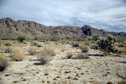
On the ground of the Sonoran Desert we found evidence of both gravelly and stony alluvial fans that spilled out of the mountain ranges into adjacent basins, and which seem to cover much of the Sonoran Desert near the mountains here in Arizona.  Further away from the mountains we found much finer sands, silts, and clays, as well as wind blown sand from the dune fields of the Gran Desierto in northwestern Sonora.  Physical and chemical weathering reduces the size of the coarse particles resulting in the finer grained sands we observed away from the mountains.  Most of the altering and transportation of materials found the in the Sonoran Desert is still caused by water, oddly enough, but I believed our tour guide when he told us this because as dry as Arizona is, it does receive a lot of rainfall in some years.  It was quite common to find large igneous rocks exposed near the mountains, and much finer sand with less large rocks the further away we went from the mountains.  You can definitely see the evidence of the mountain ranges being responsible for much of the terrain features we see in these areas.

One of the things many visitors love about the Sonoran Desert is the saguaro cactus, which is only found here in the Sonoran Desert.  They can grow to be extremely large, but are very slow growing.  It can take up to 100 years for a saguaro cactus to grow to 15-16 feet in height.

Here is a picture taken of giant saguaro cacti:


("Sonoran Desert - DesertUSA", n.d.)


Here are two other pictures taken of the Sonoran Desert, showing how different the plant life and ground mass of the Sonoran Desert can be depending on which specific area you are in:


("Top 5 Ways to Explore Scottsdale's Sonoran Desert | Official Travel Site for Scottsdale, Arizona", 2019)


("Sonoran Desert National Monument, Arizona", n.d.)


I would highly recommend that everyone come out and see the Sonoran Desert at least once in their life.  It is much too hot to visit the less populated areas of the Sonoran Desert in mid-Summer, but it is a beautiful place that everyone should see, preferably in the cooler months both before and after Summer. 


Lutgens, F., Tarbuck, E., & Tasa, D. (2016). Essentials of geology (13th ed., pp. 422-439). Pearson.

Sonoran Desert - DesertUSA. Retrieved from https://www.desertusa.com/sonoran-desert.html

Sonoran Desert National Monument, Arizona. Retrieved from http://www.americansouthwest.net/arizona/sonoran_desert/national_monument.html

Sonoran Desert Network Ecosystems (U.S. National Park Service). (2018). Retrieved from https://www.nps.gov/im/sodn/ecosystems.htm

Top 5 Ways to Explore Scottsdale's Sonoran Desert | Official Travel Site for Scottsdale, Arizona. (2019). Retrieved from https://www.experiencescottsdale.com/stories/post/the-top-5-ways-to-explore-scottsdales-sonoran-desert/

Week 3: Running Water

Even though I am originally from Denver, CO I grew up in Wisconsin and have always called it home. In the region where I live we are surrounded by the Wisconsin River. The river in itself brings many tourists each year to take in its sights and great sandstone cliffs that surround it. I often frequent the river in the summer time as many locals love to go boating and enjoy the many sand bars, beaches, and rock formations that it has to offer. The great sand stone that surrounds it was made up by the river washing away, flooding, and then back to its normal size again. One process that I learned that helps to make up a River is called, a drainage basin. This is the area that is drained by a river or a stream and the boundaries between the drainage basins are called divides. The Wisconsin River is formed by the Mississippi River which actually makes up quite a bit of the rivers in the United States. The Mississippi is made up of many smaller drainage basins that stretch all the way from Montana, to southern Canada, etc.  Many of the formations on the Wisconsin River that you see today are named and date back millions of years. My favorite formation is called the Sugar Bowl. I have attached a picture below. This formation is located on the lower dells, a more quiet reserved part of the Wisconsin River located in Wisconsin Dells. The upper dells consists of more named sand stone formations but has proven to be a lot more touristy. In the picture below you can see the sugar bowl followed by a Dells boat tour that frequents both the upper and lower dells highlighting these great wonders formed by the Wisconsin River.


Image result for picture of the sugar bowl in wisconsin Dells wi


Week 3- Wolf River

I have always found peace in being near water. There is something that calms me about being around lakes, oceans, and rivers. Growing up in Wisconsin I have had unlimited opportunities to spend time near water. As a child, my parents took us to numerous lakes to swim, picnic, and just have fun. It wasn't until I was in college that I started to be more adventurous when it came to water activities. My friends and I recently decided to visit the Wolf River in Wisconsin for a short weekend getaway and we had a wonderful time being surrounded by its beauty.
Granite Cliffs along the Wolf River in Menominee County, WI
The Wolf River is a 225 mile long tributary of the Fox River in Wisconsin. Along with the St. Croix River, the Wolf River is one of two rivers in Wisconsin that are National Scenic Rivers. The beauty of the Wolf River is undeniable. Tributaries of the river include Wildcat Creek and Pine Creek, Pine River, Rat River, Little Wolf River, Embarrass River, Shioc River, and the Red River.


Wolf River


The river has a consistent flow, stunning boulder gardens, rapids, and very limited development. The combination of these things makes for a perfect location to enjoy recreational water activities like kayaking. I had never kayaked so I felt a bit nervous. Our tour guide was kind and knowledgeable, so to say I was apprehensive when he talked about the necessity of keeping our life jackets on and stressed that people have drowned (most of which were not wearing their jackets) I was more than a bit nervous :). 
After beginning our trip I realized I didn't need to be nervous. The flow was strong but not overpowering. The landscape of the river was varied. There were times where there were dense thickets and grassy lowlands when the river was slow. and beautiful pine forest and rocky shorelines when the whitewater runs. During our adventure we saw maple, beech, and aspen hardwoods and well as spruce, balsam fir, and many, many pines. We saw eagles, herons, ducks, and raccoons. Our guide even told us we may see black bear and wolf (we did not). 


Gorgeous Wolf River in Menominee County, WI
Being in the presence of such lovely, but strong nature is one of the reasons I love living in Wisconsin. I am so grateful to have lakes like the Wolf River in my backyard. This little weekend trip was one for the record books-I tried something new, had an adventure, saw beautiful igneous rocks and animals galore! If you have the opportunity, I highly recommend traveling to Wisconsin to spend some time on the Wolf River.

River- Mississippi River

I grew up in Minnesota by the great Mississippi river.  I have always been fascinated by the river and with the recent flooding again this spring I thought it would be something interesting to discuss.  Another, tie to the Mississippi I have, is in High School (a long time ago) I was an Intern in the Human Resources Department at the Army Corp of Engineers and I worked with many of the job descriptions for the staff working the Lock and Dams along the river. 

The first thing about the Mississippi is the pure size of the river, it is the second largest river in the United States.  The River starts in Minnesota and ends at the Gulf of Mexico. The river flows 2,350 miles in its entirety.  I thought it was fascinating to learn it takes about 3 months for the water to get from the Itasca State Park (the beginning of the river) to the Gulf of Mexico.  The flow of the river is about 1.2 miles per hours or so.    The Mississippi is used for shipping and commerce and has over 500 million tons of items shipped on it river each year.  Also, has an abundance of wildlife, fish and amphibians living in or around the water basin.  I think it was pretty neat that 60% of all North American birds (326 species) use the river as a migratory flyway.(National Park Service)


Picture cited: https://www.nps.gov/miss/riverfacts.htm

The Mississippi has had great flooding over the years with millions of dollars in damages. Most of these floods were considered regional flooding based on rainfall or excessive snow melt in a short amount of time.   The picture above actually shows the watershed basin area for the Mississippi and sounding river areas.   Normally river meandering which means a river will naturally create S-shaped curves.  These channels then develop over time as sediment from bedrock is brought down the rivers path.    Meandering creates active cut banks which show erosion of the side areas of the river as they naturally flow down the river.  These active cut bank create and add more sedimentation to the river as the bedrock is slowly pull apart.   This creates natural levees over the years which help with flooding.

There is quite a bit of conversation and controversy over the Government and Army Corps of Engineers changes to the Mississippi River over the years.  Apart of the changes was they straighten the river in certain areas for quicker path for shipping and created more of a controlled river.  The natural movement of a river and river bed areas was taken away by trying to control the river.  they have had to create made made levees to create a path for the rivers.  They created channelization and flood control dams to help to alleviate flooding.  Some of the regional flooding as been so excessive over the years that dams and levees have not been successful in keeping all the water in the confined area creating massive flooding of homes and towns.  Which is so heartbreaking to see.  It is hard to understand that is just natural for rivers to flood but then see the massive destruction they can create.  It is kinda unbelievable

 
References
lutgens, F., & Tarbuck, E. (2015). Essential of Geology. New Jersey: Pearson Education, Inc.
National Park Service. (n.d.). Retrieved from Mississippi River: https://www.nps.gov/miss/riverfacts.htm


Colorado River- Week 3


I chose the Colorado River for my travel blog it runs through Austin, Texas. It comes from West Texas and flows all the way down onto Houston, Texas. It runs through 11 counties in Texas and the body is like a snake that flows for miles and miles. It is the largest river within Texas and it is the 18th largest in the United States it is about 39,900 sq miles. When it rained constantly back in January this river tends to flood and multiple dams needed to open to protect the City of Austin. 

Week 3 - The Sonoran Desert -My Home :)

I grew up in a desert globe! I’m from Tucson, AZ, surrounded by the Sonoran Desert. Growing up, I learned a lot about the warm, dry desert I call home. I learned a lot of these facts from the Arizona-Sonoran Desert Museum and years of touring the mysterious land. The Sonoran Desert inhabits an ample mass of the southwestern North American continent. The continental physiography of the desert occupies the southwestern U.S. and northwestern Mexico including half of Arizona, southeastern Cali, and most states of Sonora and Baja California, Mexico.

 
The desert is in my backyard! (Taken from my iPhone)

In grouping, the bimodal rainfall rule and the mid-continental location, this tremendous distinction in topography moderately balance and produces the astounding diversity of the Sonoran Desert. One of the greatest facts I know about the Sonoran Desert is that it has the largest species diversity of any desert in North America. This includes animals such as Bobcats, Javelina, Coyote, Bark Scorpion, Jackrabbit, and much more. Many people assume that in deserts, there is not a lot of plant life. However, there are plants that can survive the 120-degree heat! Many have evolved to have specialized adaptations to the desert climate. Brittlebush, Prickly Pear (great with lemonade), Palo Verde, Desert Marigold, and the Saguaro Cactus are the primary plants that inhabit the dry desert. 


These plants add some color to the bland desert! (Taken on my iPhone)


Around 20 and 40 million years ago, many volcanoes were vigorous in the Sonoran Desert, resulting in large basins. The tectonic activity created a lot of pressure on the primary coatings of the Sonoran Desert causing the shape or characteristic of Basin & Range topography. The Sonoran Desert receives the persistent calm winters as well as the violent summers.  If there was one word to describe the Sonoran Desert climate, it would be dry. My family would always tell visitors that “it’s a dry heat” which is better than a humid heat. 

A "mild" Summer in AZ! (Taken on my Snapchat)

The purple Catalina Mountains keep the rain away for much of the year, creating a dehydrated atmosphere. However, it doesn’t rain much in the Sonoran Desert because of the moist air moving east from the Pacific Ocean that is forced to rise over the Cascades and Sierra Nevada. Since cool air cannot hold as much water vapor as warmer air can, the additional water precipitates. Moisture blowing in from the ocean is successfully drained, and the air that travels down the ranges' eastern slopes is usually so dry it cannot produce any more rain. This marvel, or the rain shadow effect, describes such dryness on the inland side of coastal mountains.
The reliability of our hot, dry, and cloudless days is principally the result of the North Pacific high-pressure zone. The North Pacific High is a semi-permanent, subtropical high located in the northeastern portion of the Pacific Ocean. Though this all sounds like the fires from hell, the Sonoran Desert does hold its beauty. My favorite parts of the Sonoran Desert are the sunsets and wildlife. I feel connected to the desert because it’s my backyard! I’ve handled rattlesnakes, ran away from javelina, and have experienced several scare attacks from baby scorpions. This might intimate you, but fear not, the desert isn’t a hot and chaotic land. The Sonoran Desert is home to hundreds of diverse species and thriving plant life. The beauty of the desert is like no other. When the sunset surrounds the cacti, it brings out the best of this eerie, hot land.

 I encourage you all to visit! (but during the winter!)

The sunsets are worth it.


(Taken on my iPhone)


Reference: Information from the Sonoran Desert Tour
Arizona-Sonora Desert Museum, Tucson, AZ - Zoo, Botanical Garden, and Art Gallery. (n.d.). Retrieved from https://www.desertmuseum.org/

Week 3: Running Water - The Yangtze River

    While exploring in Shanghai, China, one of the only ways to travel across the seaport city (such as from main Shanghai to Changxing Island to Chongming Island) is the Shanghai Yangtze River Tunnel and Bridge:

The Shanghai Yangtze River Tunnel and Bridge

The area that this amazing man-made structure crosses is also where the Yangtze River, the third longest river in the world, ends into the East China Seas.

Yangtze River Map

    The Yangtze River is mainly sourced by several tributaries from the eastern section of the Tibetan Plateau, specifically by the glaciers that feed the Tuotuo River near the Geladandong Mountain in the Tanggula Mountains. The river is the longest in Asia, and passes through 10 Chinese provinces. The course that the Yangtze flows and meanders can be considered in three different sections: an upstream section that runs through the high Tibetan Plateau and highland mountains/valleys consisting of Cenozoic sediments (where the river falls more than 5,200 meters), a middle course that consists of lower mountains and hills (and houses the gorgeous Three Gorges area), and the lower section, where the current slows into the planes, and the water level fluctuates due to flood seasons and a number of large lakes, until emptying beside Shanghai. 
    At its mouth, the Yangtze River was thought to have output about 235 cubic miles of total water volume annually (which has decreased since the completion of the Three Gorges Dam), and the suspended sediment load is thought to be about 478 million tons per year. Flooding is an ever-constant issue, as the high amount of sediment and alluvium loads (which colors the river a coffee brown) as it moves downstream, extensive and destructive flooding can occur, such as in 1998, which resulted in over 3,700 people dead, 15 million people homeless, and $26 billion dollars in damages. China has continued to attempt to implement several flood-control measures to try to control the floods, such as with the Three Gorges Dam.
   One of the most gorgeous sections of the Yangtze River is the aforementioned Three Gorges (made of the Qutang, Wu, and Xiling gorges), renowned for its beauty, religious and historical influence, and also home of the Three Gorges Dam, a hydropowered power plant that is 
the world's largest (and most controversial, due to its economic and environmental consequences). Still, all things considered, the Yangtze River is one of the most important and impactful rivers in the world, and certainly hard to miss when visiting China!

A view above Three Gorges
A boat travelling in Three Gorges


Saturday, March 30, 2019

Week 3- Antarctic Desert

I chose the desert of Antarctica because I picture sand and cacti when I think desert and I wanted to learn more outside the stereotype.

Antarctica is considered the largest desert in the world and is classified as such because of the tiny amount of precipitation it gets annually (less than 2 inches a year!). However, due to the mile thick ice, what little bit of snow Antarctica does receive doesn't absorb into the ground, creating snow as a sort of silt. Weirdly, it has blizzards the way sand deserts have sandstorms, with snow blowing and winds raging up to 200 mph. Because of the blowing snow and freezing temperatures, ice forms into cliffs and snow dunes, creating a jagged landscape. This is a desert climate because of the sheer temperature. It's so cold, the air simply can't hold enough moisture for sufficient rain- or snowfall.

Image result for antarctic desert

Picture:
https://www.oddizzi.com/teachers/explore-the-world/physical-features/ecosystems/deserts/world-deserts/antarctic-desert/

Information websites:
https://www.universetoday.com/27064/what-is-the-largest-desert-on-earth/
https://www.livescience.com/21677-antarctica-facts.html

Week 3 - The Nile River


Source Link: http://www.crystalinks.com/egypthistory.html

Last week, my sister and I were winners of Wheel of Fortune and won a cruising trip on the Nile River which is located in Africa. From the Mediterranean Sea, our boat entered the Nile River delta. Since, it's hard to see exactly where we were, I had a map to look at. With an overview, I could see that the delta had a semi-dendritic pattern."Isn't it cool how deltas are formed, Kat?" I asked my sister. "Although deltas are formed by the amount of sediment that builds up, you really can't see the formation of one since it takes a long time to actually develop," she replied. "Which also goes to show how long the Nile River (and its sub-rivers) have existed" I said. We both wondered why the Nile River branched into two rivers: the White Nile and Blue Nile. After further research, I shared that the Blue Nile and White Nile were given specific and purposeful names. The White Nile tributary was named because it carried light-grey sediment which gave it the white-grayish color. Similarly, the Blue Nile carries black sediment that give the water a dark-blue color. My sister who was thinking about a flood that happened in our hometown a while back was wondering about floods that occurred here and if there were ways to prevent floods. Remembering reading in a geology book, I told her, "There are different types of floods: regional floods, flash floods, and ice-jam floods. Here in the Nile River, regional floods would occur since floods were seasonal. Egyptians called this time "akhet."  There necessarily aren't ways to prevent floods since they are natural disasters. Instead, there are ways to control the floods. These include creating artificial levees, channelizing river channels to make water flow efficient, and building dams. I believe there is a dam built here in the Nile River, but building dams are expensive and are only temporary solutions to flood control. The last way floods could be controlled would be having zoning regulations. That is, deciding whether there can be residence in these floodplains or not." My sister fell silent, but the smile that I saw her sneak gave me the impression that she would one day want to help engineers think of a solution to controlling floods effectively and efficiently.

Rio Grande River


Rio Grande River

At nearly 1,900 miles, the Rio Grande River is runner up to the Missouri-Mississippi. Many say that this river is under duress and dying because of multiple droughts. Snow melt from the San Juan Mountains is Colorado is the major source of water for the river. The Rio Grande River spans from San Juan Range of the Colorado Rockies to the Gulf of Mexico at Brownsville, Texas. This river was created by a rift between the Sangre De Cristo Mountains and the ranges to the west of it and volcanic activity filled the crack with lava. Many streams joined together to assist in creating this river. In the New Mexico portion that the river runs through the river is a sediment filled basin. Most of this river is also arid and semiarid and because of this, the river sits on the border of being a desert climate. It runs between canyons. This river is used for most agricultural needs and the flow in Southwest Texas decreases because of the amount of farmers that use it for their crops.


The Rio Grande River is know because it flows for much of its length at a high elevation. This river also flows through the desert. The sub-tropical lower portion is what is used to support agricultural needs. The heat from ongoing geologic activity still exists in places such as Ojo Caliente in New Mexico. The Rio Grande River is the fifth longest river in the United States. Without this river, many agricultural locations would be struggling to find water.

Week3 - Desert


            My friends and I visited the Arabian Desert, Rub'al-Khali in Saudi Arabia. It covers almost the whole of the Arabian Peninsula and lies on 900 000 square miles of land making it the largest desert in Asia. The Arabian Desert is found on the extreme parts of southwestern Asia and as a result, it has a higher affinity with Somalia and Ethiopia of Africa than other regions of Asia.
            From the air, we could see blurry mountain ranges as well as reddish sand dunes that stretched to the horizon. I explained to my friends that these escarpments and dunes were as a result of ephemeral streamflow found in deserts and the partial plant cover. The desert was formed approximately six million years ago when a rift occurrence in the earth’s crust led to the separation of the Red Sea and the Arabian Peninsula. Western Arabia was initially a part of Africa. The Red Sea now borders the Arabian Desert to the West while the Arabian Sea and the Persian Gulf are in the Southeast and East respectively. Due to the surrounding large water bodies, the desert always experiences an adjacent offshore oceanic current and depending on the season, the currents may change to strong windstorms. The currents are usually either extremely cold or hot, they can freeze or heat your body.

            The Arabian Desert has mountainous highlands and erosion has also uncovered few ranges in the region. Just like other deserts, the Arabian is covered by plateaus. Below the plateaus are broad plains with smooth and steady surfaces. The drainage channels in the desert are dry and the flow of water can only be observed when there are extremely heavy rains.  River Tigris and Euphrates perennially flow in the desert.  We noted that sand never occurred in flat sheets. As aforementioned it either accumulated in dunes of varying sizes or ridges. Walking on the topographic surfaces and observing the bluffs in the desert was an overwhelming experience.
Reference 
Rub Al-Khali - LookLex Encyclopaedia, looklex.com/e.o/rub_al-khali.htm.