Thursday, April 11, 2019

Saint Lucia- Week 5

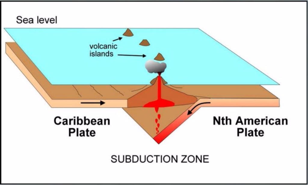
Travel journal has brought me to Saint Lucia, it is located  within the Windward Islands. It is situated along the edge of one of the more volatile sectors of Earth's crust. This is where the great American plate submerges under the Caribbean plate. Which creates a formation a chain of volcanic islands the molten rock is raised up through a fractured crust. Saint Lucia was made by these volcanic events that took place a long time ago. 


Doodnath, A. (2017, November 10). UWI Seismic Research Centre: T&T at risk for the 'big one'. Retrieved from http://www.looptt.com/content/uwi-seismic-research-centre-tt-risk-big-one

Image result for saint lucia fault plate into caribbean

The Andes


The Andes

The Andes mountain range was created due to a oceanic/continental process. The Andes mountains is one of the longest mountain ranges on earth. The forces of plate tectonics are the reason this mountain range exists. The Nazca plate moves eastwards towards the South American plate, and because of this, the range was formed. The plate still continues to move. Where the two plates meet, the oceanic lithosphere of the Nazca plate is forced downwards under the continental lithosphere of the South American plate. As if moves downwards, it drags against the overlying plate, causing it to fracture. This action causes earthquakes that causes the ocean plate to go down further. This can also cause volcanic activity. Since the Nazca plate continues to move in a downward movement, the sediments on the ocean floor scrape off and are forced towards the South American Plate. This is called obduction. The downward movement of the Nazca plate also brings sea water that has been locked in the ocean crust, into the mantle. There are different types of rocks that exist here. Less dense rocks occur at the South American plate and sedimentary and metamorphic rocks exist at the Andes.The type of stresses that occur are tensional. Reverse faults are associated with the Andes mountain range.

References:

Oceanic/Continental: The Andes. (n.d.). Retrieved April 11, 2019, from https://www.geolsoc.org.uk/Plate-Tectonics/Chap3-Plate-Margins/Convergent/Oceanic-continental

Wednesday, April 10, 2019

Abdullah Alburaidi- week 5 Converging Plates

My world exploration trip landed me to the Arabian plate that separates Arab from Africa. This is a continental collision against a continental collision because it involves the African continent and the Asian continent. The Arabian plate lies in Asia`s and the Middle East. It is home to countries like Qatar, Saudi Arabia, Oman, Bahrain, and Kuwait among others. The notable structural deformations in the area are the Red Sea, the Zagros Mountains, hydrocarbon reservoirs, Harrats and the Gulf of Aden. The types of stresses involved in the margin formation are both tensional and compressive because the plate has normal faults on its Western side and the kind of rocks being deposited are sedimentary rocks. Faulting dominates the plate with the existence of the Dead Sea transformed faults boarders. The faults in the Arabian plane are normal because it appears like the hanging wall is facing downwards and it is parallel to the footwall. Also, in support of the faults being normal, the collision is between two rocks (two continents).

References

Africa-arabia-plate.weebly.com. (2019). Arabian Plate. Retrieved from https://africa-arabia-plate.weebly.com/arabian-plate.html

Tuesday, April 9, 2019

Week 3: ParanĂ¡ River (South America)

Source: https://www.pinterest.com/pin/156851999493539569/


This week I decided to focus on Rivers, specifically, the  ParanĂ¡ River. It has been noted that this is the second longest River after the Amazon. This river can be found in South America and it rises on the plateau of southeast-central Brazil. According to research, the headwaters of the ParanĂ¡ are on the slopes of the Serra dos Preneos in Brazil.

It has also been reported that many high altitude streams from this specific region join in to help form the Paranaiba River, which continues to flow southwest to form the Rio Grande. it is said to cover 2.8 million square kilometers and includes what is now known as the Iguazu Falls. the water from this river is said to supply water to the plains biome.

According to research the Parana River has a solid load that is laregely recycled sedimentary material that happens to be muddy. It should be noted that the main meadnering channels are connected and interconnected by many smalled channels with constantly shifting paths. This river looks like a lake that eventually turns into a waterfull due to the big drop that it has in its center. Heavy rainfalls in May of 2017 has led to flooding of this river. This kind of flooding has been on going around this specific river due to the rain fall. 

Despite these complications the river offers a beatiful combination of greenlife and water. Its curves and drops are very scenic making it a pleasant site to see. There appears to be a slit midst above where the drop is likely to occur. While the wate may have a brown color to it due to its load its combinations of colors is still full of life making it one site to see.


Resources: 1. https://www.britannica.com/place/Parana-River

                    2. https://link.springer.com/chapter/10.1007%2F978-94-017-3290-1_11

                    3.https://www.nationalgeographic.org/encyclopedia/south-america-physical-geography/

                    4. https://gizmodo.com/this-is-a-beautiful-glimpse-into-the-history-of-a-shift-1677343158


Week 4 -Volcano

This week I will be exploring the Augustine Volcano in Alaska. It has been noted that this volcano is the most active volcano of the eastern Aleutian arc. Reports say that in 1883 there was a devastating volcano that erupted because large parts of the summit dome complex collapsed. It took several centuries for the volcano's height to restore. It has also been noted that eruptions after this eruption have been explosive. These explosions have produced something called pyroclastic pumice flows and block-and-ash flows, this was followed by regrowth of the lava domes.

According to Britannica, pyroclastic pumice flows are a "fluidized mixture of hot rock fragments, hot gases, and entrapped air that moves at high speed in thick, gray-to-black, turbulent clouds that hug the ground. This is evidence that was left after a number of explosions that this volcano produced.

This volcano is considered to be a stratovolcano which means that this volcano was built up of alternate layers of lava and ash. In terms of the hazards associated with this volcano one should look at hazards formed by ash clouds and ashfall. According to research, these volcanos are distrubuted under Pacific great circle aircraft routes and can erupt ash clouds into commercial and recreational and recreational airspace. Mixing ash and aircrafts could cause an aicrafts engine to fail leading to fatalities of aircraftmen and women. Ash fallout which is a product of eruptions can lead to problems with infrastructure and can also lead to what is called a respiratory hazard.


Source: https://www.volcanodiscovery.com/alaska/augustine.html
https://www.britannica.com/science/pyroclastic-flow#ref884244
https://avo.alaska.edu/volcanoes/hazards.php

Monday, April 8, 2019


Jon Morris: Theory of Plate Tectonics (Week 4)

Continuing with our tradition of attempting to find interesting geological features in our home state, my family and I visited the San Francisco volcanic field, which is located near Flagstaff, Arizona.  Of course, we were only able to check out a small portion of it, because the San Francisco volcanic field covers 1,800 square miles.  In particular we decided to visit Sunset Crater, primarily because it is easily accessible as opposed to some of the other areas in the San Francisco volcanic field. 
While at the Sunset Crater National Monument, we learned that the Sunset Crater is actually the youngest in the string of volcanoes that are within the San Francisco volcanic field.  Interestingly, original estimates determined that the eruption of the Sunset Crater volcano began somewhere between A.D. 1064 and 1065.  They used tree ring dates, or dendrochronology, as the method of dating the eruption, but more recent evidence suggests that the eruption actually began around A.D. 1085.  Although we did not find definitive information about why the San Francisco volcanic field, and the Sunset Crater exists where they are, the common belief is that the area was formed from a geological hotspot, which are volcanic regions that are thought to be fed by underlying mantle that is deviating in heat, or inconsistent as to heat levels with the surrounding mantle.  Many believe that the position of hot spots on the surface of the Earth are independent of tectonic plate boundaries, however we do know that as the North American plate moves over the spot, new volcanoes appear.  The Sunset Crater is considered extinct, but we were astounded to find out that in 2015 there was an eruption scare after a website with images of steam rising from the Sunset Crater had some people believing the volcano was about to erupt again.  The cause of the steam was later determined to be from a forest fire, thank goodness!  If it had actually erupted again, it would not be the first time it potentially displaced people since it is known to have forced the Sinagua people to temporarily abandon their settlements when it erupted around A.D. 1085. 
The good news is that as far as we have been told, the Sunset Crater is extinct and not likely to erupt again, which is really good news because its initial eruption was responsible for the Bonito and Kana-a lava flows that extended about 2.5 kilometers northwest and 9.6 kilometers northeast.  Additional vents extended along a 10-kilometer fissure to the southeast and also produced a 6.4-kilometer lava flow to the east.  The Sunset Crater eruption produced a blanket of ash and lapilli (various shaped droplets of molten or semi-molten lava ejected from an eruption) covering an area of more than 8120 square miles.
These days the Sunset Crater has re-vegetated and is quite beautiful.  While we can feel fairly safe that the Sunset Crater is no longer going to erupt, it was scary to learn that the San Francisco volcanic field itself is still considered active and that a future eruption in the area is a statistical certainty.
Here are a couple of pictures from out trip, I highly recommend making the journey if you are able.  The region as a whole is quite remarkable, and there are many places to observe volcanoes in the area.


                               ("Sunset Crater Volcano National Monument (U.S. National Park Service)", 2018)


                                  (Cassidy, 2016)
Cassidy, J. (2016). Sunset Crater Volcano National Monument. Retrieved from https://www.azcentral.com/story/travel/arizona/2016/08/22/sunset-crater-volcano-national-monument/88806972/

Sunset Crater Volcano National Monument (U.S. National Park Service). (2018). Retrieved from https://www.nps.gov/sucr/index.htm

Week 4- Volcano

For my travel blog I visited the Pilot Knob it is the largest extinct volcano in Central Texas. It was an active volcano before the city of Austin was planted here. The history of this volcano it is located in the State Park McKinney falls and it use sit covered with a shallow sea in a tropical climate. I got the chance to see it the material that lies beneath this is volcanic igneous rock.

Pilot Knob: Largest Extinct Volcano Remaining in Central TexasPhoto Credits-Sault, Spring. "Pilot Knob: Largest Extinct Volcano That Remains in Central Texas." Texas Hill Country. February 27, 2018. Accessed April 08, 2019. https://texashillcountry.com/pilot-knob-largest-extinct-volcano-remaining-in-central-texas/2/.