Tuesday, November 17, 2020

Week 5 Converging Plates -- Robbie Todd II


While living out in California I lived a 15 minute ride from Mormon Rocks.  It got its name from Mormon settlers in 1851.  This is an amazing place and really fun to hike around.  Lots of different trails and climbing spots.  My dog Griffey and I would go explore almost every weekend.  Some of the small things I missed about living there.


So let me tell you about how the Mormon Rocks were created.  These rock features are at the southern end of the san Andreas Fault in California.  The San Andreas fault is the most important tectonic structure in California.  It is a right-lateral strike-slip fault that has some subsidiary faults at the boundary between the Pacific and North American Plate.


The Mormon Rocks is a great example of how tectonic forces can uplift and tilt strata.  Mormon Rocks are sandstone that has been pushed up by a sub-fault of the San Andreas fault.  While climbing around you can see the uplifting and folding that is happening in the area.  You can see the sandstone has been worn down by the winds and rains over time.  It is a great place to see the forces of plate tectonics and climbing around it very fun.

Robbie


Reference

Field trip 3: San andreas fault, mormon rocks, and devil's punchbowl: Earth science field trips in southern california. (n.d.). Field Trip 3: San Andreas Fault, Mormon Rocks, and Devil's Punchbowl. Retrieved November 17, 2020, from https://cerritos.instructure.com/courses/31759/pages/field-trip-3-san-andreas-fault-mormon-rocks-and-devils-punchbowl

Sunday, November 15, 2020

Week 4: Volcanoes Brandon Thammasine

     I visited the Kilauea volcano in Hawaii. Located in the southeastern part of Hawaii, Kilauea is the youngest volcano on the island. Not being the only volcano on the islands, Kilauea and many of Hawaii's volcanoes were formed in the middle of the Pacific Plate and rose from the ground through a hot spot. This is interesting because hot spots do not form from Earth's moving tectonic plates. Instead, heat from Earth's mantle moves up through the lithosphere and eventually makes it way up to the Earth's crust. Magma then reaches Earth's surface through cracks in the crust which form volcanoes like Kilauea and many others in Hawaii (National Geographic Society, 2012).


Stream of lava from Pu‘u ‘Ō‘ō flowing through the forest in the Royal Gardens subdivision, February 28, 2008. USGS.gov

     It is clearly evident that Kilauea has erupted before as it is an active volcano. Aside from it being active, there are visible basalt formations around the landscape of the volcano which form through the cooling of magma. Based on the basalt formations, it also can be inferred that the eruptions were slow-flowing. The formations help prove that streams of magma have flowed through the lands. 

    As mentioned earlier, Kilauea is an active volcano so the land surrounding it is a hazard to people as an eruption of hot magma is likely to happen. 


References


National Geographic Society. (2012, October 09). Hot Spot Volcanism. Retrieved from https://www.nationalgeographic.org/article/hot-spot-volcanism/#:~:text=A hot spot is a,the crust to form volcanoes.&text=Instead it occurs at abnormally hot centers known as mantle plumes.

Week 4 Volcanoes- Ryan

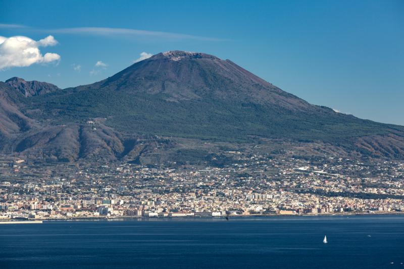
 Hiking Mount Vesuvius | ITALY Magazine

This week I decided to take a trip to Italy and visit the great Mt. Vesuvius. Vesuvius is located on the Campanian volcanic arc, a line of volcanoes formed over a subduction zone. The volcano is most famous for its eruption in 79 AD when it destroyed the cities of Pompeii and Herculaneum. Today, Mt. Vesuvius remains an active volcano and represents a great danger to surrounding cities even though the last eruption was in 1944. As of right now, Vesuvius only has minor seismic activity however violent activity could resume in the future. 

Week 4- Volcano - William Moran

Mount St. Helens


    Located in Washington state Mount St. Helens is considered a dacite volcano. A dacite volcano is light in color and made up of volcanic rock with heavy concentration of silica and potassium. The volcano is the most active in the Cascade range and was formed 275,000 years ago through four separate stages. The main portion also known as the edifice, of older St. Helens was formed sum 12,800 years prior. The newest edifice which is part of the lower crater was formed about 3,000 years ago. St. Helens had a steam eruption in 1980. Following the eruption came periods of quiescent followed by a small eruption. Mount St. Helens will most likely erupt again but it is hard to find out when and at what magnitude.


A journey to the Mexican Volcano “the Popocatepetl”


Ricardo Aguilar

A journey to the Mexican Volcano “the Popocatepetl”


The Popocatepetl is a Mexican volcano that in recent time registered a strong explosion, this is a volcano that has been active for at least 25 years in modern time. After a long period, quietness in which no major explosions were recorded. It was on 2999 B.C this according to a detailed record of the activity of the Popocatepetl of the general coordination of civil protection of the State of Puebla Mexico. The records indicated that for that year there were “lava fluids”

And it was until the 16th century that eruptive sequences were recorded, however the damaged caused by this volcano on that time is unknown.


However, in the first half of this century there was less activity and there has been talks of some victims inside the crater when mining sulfuric acid. This according to a document of the civil protection department of the city of Puebla Mexico. consequently in 1994 could be called the year of the Popocatepetl awakening, due to an increased activity on that year, also it was in that year that for the first time on the history an evacuation of nearly 50,000 people took place due to this volcano’s activity, another 30,000 had to be sheltered for six hours due to the increased activity of the volcano as well, this according to such civil department report.  


from the time of the eruption recorded above lines there was a period of “relative calm”, according to the civil protection such volcanic inactivity would be interrupted in the year 2000 when the larges eruption on terms of energy release occurred, by then fortunately a preventive evacuation had been ordered. In such event a total of 14,000 people from diverse towns around the volcano needed to be evacuated.  The year 2000 would be the last time that large activity has been recorded in this volcano located between the states of Morelos Mexico and Puebla Mexico. since then, only until the year 2017 there has been several episodes of volcanic ash expulsion and the volcano as launched incandescent fragments to a bout 900 meters from the edge of the crater. until now no further regarding a serious dangerous activities information has been recorded on the volcano.


Picture source:

https://en.wikipedia.org/wiki/Popocat%C3%A9petl#/media/File:PopoAmeca2zoom.jpg


Week Four - Volcanoes - Joshua Rosson

                                   (Pictures of the Hamblin-Cleopatra Area source: https://www.nps.gov/media/photo/gallery-item.htm?pg=656007&id=D3998E04-9BDF-C88C-2FD2EABDDD1AB37E&gid=D35DBD43-CF50-A8B3-85BC9D2E5DFB2F7B)


A forty-five-minute drive away from Las Vegas lies a dormant volcano that once expanded three thousand feet high and eight miles in circular width. Hamblin-Cleopatra volcano nestled in the northern shore of lake mead was once a rapidly forming stratovolcano that straddled the Hamblin Bay Fault. This quiescent volcano had split into three different formations over the course of millions of years due to earthquakes from the fault that it rested upon. However, the most intriguing portion of this volcano is the magnetic polarity of the three lobes. Both the Central and Cleopatra lobes show a split between reverse and normal polarity rocks. However, the rocks within the Hamblin lobe of the volcano are strictly reverse polarized. This is intriguing due to the age of the volcano showing evidence of axial tilt during the Miocene era.

References:

Lutgens, F. K., Tarbuck, E. J., & Tasa, D. (2016). Essentials of geology. Hoboken, NJ: Pearson.

Wawrzyniec, T. F., Geissman, J., Anderson, E. R., Harlan, S. S., & Faulds, J. (2001, August). Paleomagnetic data bearing on style of Miocene deformation in the Lake Mead area, Southern Nevada. Retrieved November 15, 2020, from https://www.researchgate.net/publication/222892032_Paleomagnetic_data_bearing_on_style_of_Miocene_deformation_in_the_Lake_Mead_area_Southern_Nevada

Anderson, E. R. (2019, October 8). Hamblin-Cleopatra Volcano. Retrieved November 15, 2020, from https://www.nps.gov/lake/learn/nature/hamblin-cleopatra-volcano.htm

Week 4 - Volcanoes


I am so happy that this week I finally made it to Hawaii!  I am here at Kilauea which is Hawaii's youngest and most active subaerial volcano (above sea level).  It has been erupting continuously since the early 1980s.  Kilauea is a shield volcano, which means that it is almost entirely composed of lava flows, and the shape that it forms is similar to that of a warriors shield.

Like the other Hawaiian volcanoes, Kilauea was created by the Hawaii Hotspot.  This location has been well studied and is a mantle plume that has remained stationary as the plate has moved over it.  Why it is like that is not well understood and makes this location something special.

Kilauea was originally through to be a vent off of its neighboring volcano.  Interestingly, it wasn't until the chemical composition of the lava showed that Kilauea has its own magma chamber making it a distinct volcano.  Given the location of this volcano and its proximity to civilization makes it the USGS's most likely U.S. volcano to threaten lives and infrastructure.  Looking forward to seeing everyone next week from the next location on my geologic tour of the world.