Sunday, September 8, 2019
Week 7 - Death Valley
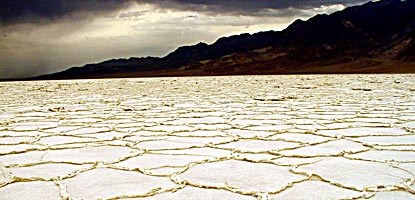
The area I chose to visit was the salt flats in Badwater Basin, which is an area that “covers nearly 200 square miles and is one of the largest protected salt flats in the World” (NPS, 2015). According to my guide during the tour, there are three basic components needed for the formation of salt flats which are source of salts, an enclosed basin, and arid climate. The composition of much of the salt flats include sodium chloride, or table salt, with silt, fine sand, and clay. Other minerals include calcite, gypsum, and borax. The colors range from white to light grays to brownish grays.
The basin boundaries must be mapped along with any additional deposits which help protect or stabilize the surrounding areas. The informational packet at the basin also suggested that much of the area was restricted, so I’d certainly be curious to find out how often surveys are conducted and what methods researchers use to work in such a restrictive area.
References
Fridrich, C.J., Thompson, R.A., Slate, J.L., Berry, M.E., and Machette, M.N., 2012, Geologic map of the southern Funeral Mountains including nearby groundwater discharge sites in Death Valley National Park, California and Nevada: U.S. Geological Survey Scientific Investigations Map 3151, 20 p. pamphlet, 1 sheet, scale 1:50,000.
National Park Service (2015, February 28). Salt Flats. Retrieved from https://www.nps.gov/deva/learn/nature/salt-flats.htm
Subscribe to:
Post Comments (Atom)

No comments:
Post a Comment