Sunday, April 7, 2019

Week 4: Kohala Volcano


Source Links:
https://en.wikipedia.org/wiki/Mauna_Loa
https://en.wikipedia.org/wiki/Kohala_(mountain)

Reference(s):
http://www.soest.hawaii.edu/GG/HCV/haw_activity.html


In deciding which Hawaiian Island to visit again, my sister and I chose to take a cruise to the Big Island. My sister wanted to have a nice vacation there, and I wanted to show her the very old Kohala volcano (but now considered more of a mountain). Upon arrival, my sister and I headed straight to Kohala since I knew she just wanted to enjoy the rest of the week back at the hotel.

To our amazement, we didn't see any magma spewing out or any surrounding molten rock. Like most Hawaiian shield volcanoes, Kohala is located over the Hawaiian-Emperor seamount chain on top of hotspots. We chipped away some rock to find a similar rock we have seen a couple weeks back: basaltic rock. This basaltic rock had already took a solid form. In fact, it wasn't quite surprising knowing that Kohala is a quiescent volcano. Finally finding signal on my phone, I searched up the approximated time the Kohala volcano last erupted. Ken Rubin, the author of Hawaii Center for Volcanology show us that Kohala's last eruption occurred 120,000 years ago! When I showed this to my sister, we were both in shock. We are now standing on the oldest shield volcano among the Hawaiian shield volcanoes. With the Kohala volcano, there is less likely to be any hazards to occur compared to Mauna Loa and Kilauea shield volcano brethren because it is not likely to erupt again. A particular detail that interested me is how close the shield volcanoes are with each other. The fact that Kohala is the oldest among the five hawaiian shield volcanoes really amazes my sister and I.


Ce-Jay Locquiao

Week 4 -Volcanoes- Diamond Head

Last summer, I was lucky enough to spend an amazing two weeks in Hawaii.  One week was in Oahu by Waikiki Beach just a short walk away from Diamond Head.     From my hotel,  you could see Diamond head out the window.   It was amazing to see a volcano so up close and personal.  At first glance it really just looks like a small mountain (compared to Colorado mountains).   This visit had me curious to learn more about the Volcano and especially Diamond Head. 
https://www.tripadvisor.com.sg/LocationPhotoDirectLink-g60982-d285170-i91217831-Hostelling_International_Waikiki-Honolulu_Oahu_Hawaii.html
photo: www.tripadvisor.com

I thought it was interesting  Diamond Head name was changed after Western travelers back in the 1700 saw crystals in the volcano and thought they we diamonds.  Originally, the volcano was called Le'ahi or  'fire headland' for the fires that were lit on the volcano to help canoes find their way to land.   

Diamond Head is considered a Cinder Cone Volcano.   Cinder Cone volcanoes are formed "when ejected lava fragments begin to harden in flight to produce vesicular rock called scoria." 
(Lutgens & Tarbuck, 2015)  These fragments can vary from ash to large rock which are referred to as "bombs".    The fragments are usually peas size rocks fragments and are black to reddish-brown in color.   The crater in the middle of a Cinder cone volcano is created due to explosive nature of the specific volcano.  Diamond Head is considered a Tuff Cinder Cone due to the large crater it has.   Cinder Cone volcanoes have steep sides and slopes between 30 to 40 degrees.
Photo: http://dlnr.hawaii.gov/dsp/parks/oahu/diamond-head-state-monument/

Diamond Head was created like most cinder volcanoes with one short lived volcanic event.  Once the event stops the magma solidifies so the volcanoes becomes dormant and usually does not erupt again.    I thought it was interesting that just like Diamond head their are thousands of cinder volcanoes around the world.  With Cinder volcanoes, the lava does not normally flow from the creator; it usually finds a unconsolidated base of the cone where the lava flows due to the volcano being made of loose fragments of rock.   Diamond Head is a dormant volcano and will not erupt again.

The Hawaiian island of O'ahu was created by Shield volcanoes 2.5 million years ago.   It is thought that Diamond head was created about 300,000 years ago as a brief eruption.

It is interesting to read and learn more about place you have visited.  I hope to go back to the Hawaiian island soon to explore everything else they have to offer. 
 

References

Division of Land and Natural Resources. (2019). Retrieved from Diamond Head State Monumnet: http://dlnr.hawaii.gov/dsp/parks/oahu/diamond-head-state-monument/

Lutgens, F. K., & Tarbuck, E. J. (2015). Essential of Geology. New Jersey: Pearson Education, Inc.

Week 4- Morgan Florence


Virtual visit of Adwa stratovolcano in Ethiopia. This region is caused by magma intrusion from the eastern side of the volcano. Little known information is known about this volcano as is has been inactive for so many years, an unknown of the last eruption. Adwa is considered to be quiescent due to its dormant present of seismic activity. Hazards such as absent information, and the location of Adwa – could potentially cause intrusion to the surrounding ecosystem due to primitive composition. It is deemed unlikely of this volcano to erupt. Afar Triple Junction is interesting to me for multiple reasons. This causes horizontal stress, which strikes radially away from the volcanos center. In result, causinf regional stress and plate tectonic separation.


Image result for adwa volcano

*Volcanic Plugs                                                                                                                       

Week 4 - The Eyjafjallajökull Volcano

Recently, Iceland was often a considered a layover in travels, as its location is prime for connecting flights going in and out of the US and Europe. However, these days, Iceland can be considered a tourist destination, with gorgeous landscapes, picturesque views at every step, and numerous hiking activities. However, in March in 2010, planes coming in and out of Iceland and Europe abruptly halted for several days, due to the eruption of Eyjafjallajökull and the subsequent plume of volcanic ash that traveled several kilometers into the atmosphere, as seen in the video below:


Eyjafjallajökull standing at 1,651 meters with an ice cap that stretches about 2.5 kilometers, is considered a stratovolcano, or a volcano built up of layers of lava, tephra (material produced from eruptions), pumice (volcanic rock) and ash that are steep with a summit crater. For Eyjafjallajökull, this leads to explosive eruptions, with fissure vents occurring along the side of the volcano, fed by a magma chamber underneath the mountain. This volcano is only one of numerous volcanoes that can be found in Iceland, all part of a volcanic area over the mid-Atlantic Ridge, which is a mid-ocean ridge derived from a divergent tectonic plate boundary between the North American and Eurasian plates. 


Active Volcanic Areas and Systems in Iceland (from Wikipedia Commons)
In addition to having a name that is infinitely hard to pronounce (ay-ya-fyad-htla-yuh-kuhtl?), the large plumes of ash from Eyjafjallajökull that lasted for weeks in Iceland caused havoc on neighboring farms and towns in 2010, killing cattle, destroying farms, and greatly reducing the air quality around the area. Because of the ice melt of the involved glaciers and its interaction with the magma, the volcanic ash plumes reached a peak of 8-9 kilometers. While Iceland and other countries affected by the numerous clouds of volcanic ash over the following months, the other worry (which continues into the present-day) is an eruption of Eyjafjallajökull's neighboring sister volcano, Katla, who shares the same magma chamber and could produce a much more damaging eruption, and has been historically known to erupt within the decade after Eyjafjallajökull eruptions - however, Katla has not shown any major signs of erupting... yet. 


Eyjafjallajökull Erupting Behind a Traditional Icelandic House (from Getty Images)


References:
Global Volcanism Program, 2013. Eyjafjallajokull (372020) in Volcanoes of the World, v. 4.7.6. Venzke, E (ed.). Smithsonian Institution. Retrieved from https://volcano.si.edu/volcano.cfm?vn=372020.

Eyjafjallajokull. (n.d.). Retrieved from https://adventures.is/iceland/attractions/eyjafjallajokull/

Eyjafjallajökull Eruption | British Geological Survey. (n.d.). Retrieved from https://www.bgs.ac.uk/research/volcanoes/icelandic_ash.html

Saturday, April 6, 2019

Week4- Popocatepetl Volcano 
(Bethsaida Colina)


Related image
Popocatepelt

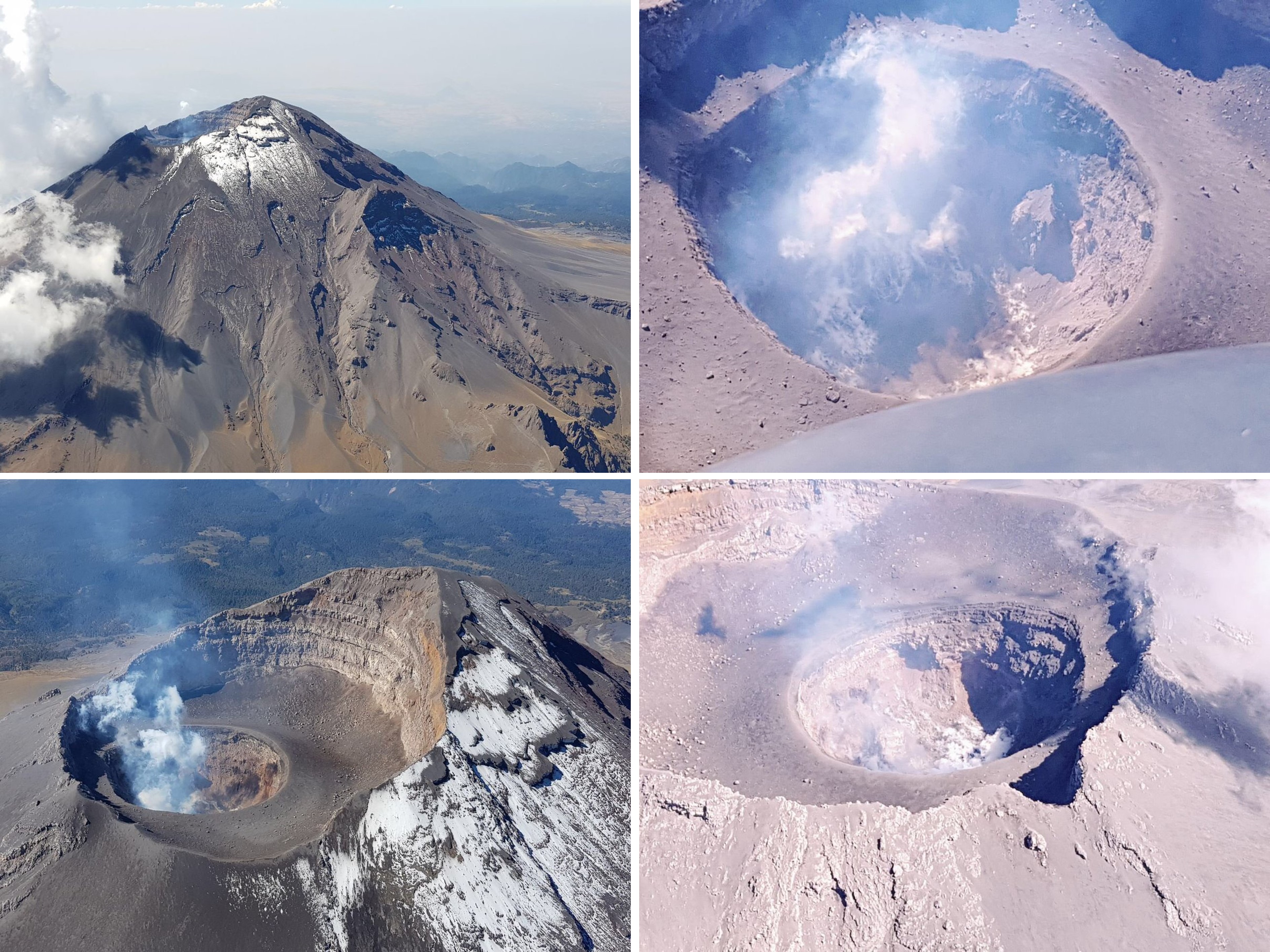
The Popocatépetl Volcano is located in the states of Puebla and Morelos, in central Mexico, and lies in the eastern half of the Trans-Mexican volcanic belt. It is the second highest peak in Mexico, after Citlaltépetl (Pico de Orizaba). The glacier-clad stratovolcano contains a steep-walled, 250-450 m deep crater. According to paleomagnetic studies, the volcano is about 730,000 years old. It is cone shaped with a diameter of 16 miles at its base, with a peak elevation of 17,880 ft. The crater is elliptical with an orientation northeast-southwest. The walls of the crater vary from 1,970 to 2,760 ft in height. The name Popocatépetl comes from the Nahuatl words popōca "it smokes" and tepētl "mountain", meaning Smoking Mountain. The volcano is also referred by Mexicans as El Popo or Don Goyo. The Popocatépetl is one of the most active volcanoes in Mexico and the most famous having had more than 15 major eruptions since 1519.

Hazards: Popocatépetl’s lava has historically been predominantly andesitic, but it has also erupted large volumes of dacite. Magma produced in the current cycle of activity tends to be a mixture of the two. Popocatépetl, which is a complex newer volcano over several older volcanoes, has historically produced large eruptions every 500 to 1,000 years. An eruption in the 1660s plunged the city of Puebla into darkness for three days as ash filled the sky.  Since the volcano’s activity resumed in 1994, several medium-size eruptions have sent ash as far as Mexico City and created plumes almost four miles high. An explosion in 1996 killed five mountain climbers. Also some hazards include the destruction of crop and vegetation, shortened periods of rains and contaminated water surfaces. People living around this region are likely to suffer skin infections and respiratory complications from the substances released in the atmosphere.

Figure (see Caption)
Popocatépetl volcano showing degassing and a small dome within the summit crater. Photos taken during an overflight on 16 March 2018 courtesy of Luis Felipe Puente at Protección Civil del Estado de México.

The Popo is currently active after being dormant for about half of last century.
The Popo last explosion was on March 19, 2019 sending a plume of ash and gas more than two miles into the inky sky and raining glowing rocks onto its slopes. Since the Popo is an active volcano, we can expect more eruptions or explosions. 

https://volcano.si.edu/volcano.cfm?vn=341090
http://www.cenapred.gob.mx/cgi-bin/popo/reportes/ultrepi2.cgi

Week 4- Mount Vesuvius

Image result for mount vesuvius
http://www.independent.com.mt/articles/2018-12-18/world-news/2-000-years-after-devastating-eruption-signs-that-Mount-Vesuvius-coming-back-to-life-6736201008
Mount Vesuvius in Italy is most famous for its eruption in 79 AD when it buried the city of Pompeii. When it exploded, it shot debris and hot gas 9.3-19  miles into the air and lasted 18-24 hours (Vesuvian Eruption) before settling into the Pelean Phase, which was characterized by molten lava flowing down the sides in a pyroclastic flow. It had been dormant for many years prior to this event, which is why the people were caught off guard and unable to escape. Those who were able to escape the lava flow were buried in the quickly falling ash.
https://en.wikipedia.org/wiki/Eruption_of_Mount_Vesuvius_in_79#Nature_of_the_eruption
Image result for pompeii
https://en.wikipedia.org/wiki/Pompeii

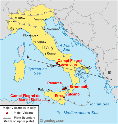
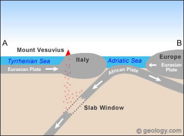
It is a stratovolcano, or composite, and is characterized by its large, symmetrical cone shape due to the alternating layers of erupted cinders and ash. According to the video, this type of volcano has a high silica content, creating a highly viscous lava that can travel pretty far without much of a grade in lava tubes, which are created by the edges of the lava flow cooling before the center to make a barrier for a lava highway. They also have extremely high gas pressure, which create clouds of volcanic ash that can stay in the air for days and travel really far. It is located in the Campanian Volcanic Arc, which is comprised of a series of volcanoes that formed when the African and Eurasian plates came together. It sits over a slab window, which is when the upper subducting slab detaches from the lower, making most of the rocks erupted from this volcano andesite, which is extremely explosive. This makes Vesuvius extremely dangerous. However, it is quiescent right now, with minor earthquake and gas emission activity, but it could very quickly escalate in its activity. As far as hazards are concerned, it's extremely volatile and sits close to water so, besides the eruption itself, tsunamis are an issue. The ash and gas released are also very dangerous. It also create earthquakes.
https://geology.com/volcanoes/vesuvius/

location map for Vesuvius volcano
Plate tectonics of Mount Vesuvius
https://geology.com/volcanoes/vesuvius/

Friday, April 5, 2019

Dotsero Colorado's only active Volcano

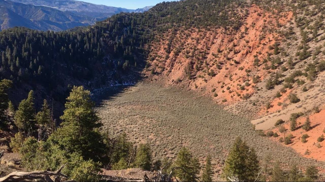
Image result for dotsero volcano

Dotsero crater is a Maar volcano with a scoria cone. Its last eruption is classified as an explosive eruption with a lava flow. The eruption was caused when groundwater and magma encountered and created the explosive eruption. The hazards include an explosive eruption that sent tephra across the area, and the fallout caused by the tephra caused a lot of red sandstone in the area. Magma flows of basaltic in the area can also be seen. The crater today is 2,460 ft in diameter and 250 ft deep. The most recent eruption is from 4,150 years ago, and it has a current eruption potential of moderate. An interesting fact is that I70 actually cuts through the lava flow from the last eruption.