Thursday, April 9, 2020

Week 5 – Jacob Fisher – Cascadia Subduction Zone


This week I visited the Cascadia subduction zone, a convergent plate boundary that spans from northern California up into British Columbia. The fault separates the Juan de Fuca and North American plates. The Juan de Fuca plate is being subducted beneath the North American plate to the east while being driven from the west by seafloor spreading at the Juan de Fuca Ridge. The fault is a thrust type due to the compression from the convergent plate boundary. (Pacific Northwest Seismic Network, n.d.)
Subduction of the Juan de Fuca Plate beneath the North American Plate [PHOTO: https://www.usgs.gov/media/images/subduction-juan-de-fuca-plate-beneath-north-american-pla]
The subducting slab causes the overlying mantle to partially melt, forming the magma that sustains the Cascade Range of volcanoes (black triangles in the above graphic). The rocks found throughout the Cascade Range are primarily andesite and dark basaltic rocks that contain very little silica. (Graham, 2005)

References
Cascadia Subduction Zone. (n.d.). Retrieved April 9, 2020, from https://pnsn.org/outreach/earthquakesources/csz

Graham, J. (2005). Mount Rainier National Park Geologic Resource Evaluation Report . National Park Service U.S. Department of the Interior. Retrieved from https://irma.nps.gov/Datastore/DownloadFile/425308

Wednesday, April 8, 2020

Week 5 - Mount Everest/Himalayas - J.Haynes

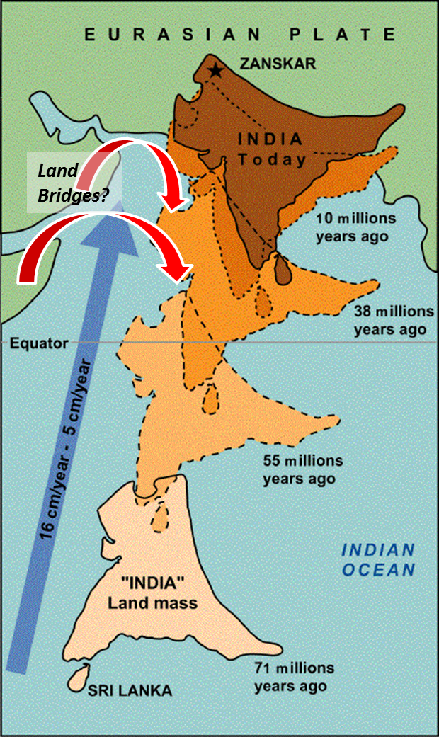
This week, my wife and I decided to visit Mount Everest in the country of Nepal. Considering China's battle with COVID-19, entrance into their country's area where Mount Everest is shared, is off limits. With this, Mount Everest is part of the Himalayan mountain range that was the result of the collision between the Eurasian and Indian Plate in which then resulted into four tectonic sub-units that compose of the Himalayas today. Millions of years ago, these landmasses above these plates were once separated continents in which has since met by way of plate to plate and continental crust to continental crust convergent collisions.

With the help of a helicopter tour, my wife and I were able to see deformation involving 'Ductile' and 'Brittle' types given the 'fluid' shape or pieced rock present. Existence of both types is mainly due to the vastness of the Himalayas', various temperature, confining pressure, strain rate, and composition that is present within its' near 230,000 square miles. Accompanying us within this tour was a Guide whom seemed extremely knowledgeable with all that is the Himalayas and Mount Everest. The Guide told us how the Himalayas consists of different fault zones based on obvious characteristics present. With this, they explained some of the zones being the Greater Himalaya Sequence (GHS), Main Central Thrust (MCT), and the South Tibetan Detachment (STD). The MCT was described as the major fault that was the result of the Indian Plate pushing under the Eurasian Plate along the entire length of the Himalaya (see map below). With this, the helicopter flew over an area where it could be seen how this thrusting process created what is now known as the Lesser Himalaya.

When the Indian Plate collided and thrusted over the Eurasian Plate, detrital, granites, and acid volcanic rock sediments from the Indian Plate then deposited and formed what is the Lesser Himalaya Plate. Though, as mentioned, a combination of faults and folds make up the Himalayas. From the regions that the helicopter covered, 'Brittle' thrust and reverse faults seem to dominate the structural style of these areas. With this considered, compressional forces dominate considering the Indian Plate is still moving centimeters per year, under thrusting the Eurasian Plate in which continues to push the Himalayas higher!


[Above Image Source]:  (Searle & Treloar, 2019)

[Below Image Source]:  (Himalaya Journey, 2020)


References:

Himalaya Journey. (2020). Mount Everest Adventure. Retrieved 08 Apr. 2020 from: https://himalayajourney.com/tour/mount-everest-adventure/.

Searle, M.P. & Treloar, P.J. (01 July 2019). Introduction to Himalayan tectonics: a modern synthesis. Retrieved 07 Apr. 2020 from: https://sp.lyellcollection.org/content/specpubgsl/483/1/1/F1.large.jpg.

USGS. (15 Sep. 2014) Understanding plate motions. Retrieved 07 Apr. 2020 from: https://pubs.usgs.gov/gip/dynamic/understanding.html.

Tuesday, April 7, 2020

Evan Lieberman Week 5 Convergent Plate Boundaries Mt.Everest

Credit:doyouremeber.com
For this week's adventure, I decided to visit the site of a continental to continental plate collision. This tends to occur after an oceanic plate that may have been buffering the two plates is destroyed, bringing the two continental plates together.  As it's pretty hard to go anywhere right now, I once again hopped into my time machine, setting the dials back to 2016 (just to be safe).

One of the most striking example of this type of convergent boundary is the Himalayan mountain range which spans Nepal and China.  This range also happens to contain the highest peak on Earth, Mt.Everest.  I emerged from the time tunnels in 2016, at the base of mountain, and looked waaaaay up.


Credit:britannica.com
The awe inspiring chain that contains this mountain is an example of Alpine-type mountain building.  This type of mountain chain can also "involve the accretion of continental fragments or island arcs that occupied the ocean basin that once seperated the two continental blocks"(Ch.11, pg. 308).  The formation of the Himalayas was relatively recent in terms of geologic time.  "The mountain-building episode that create the Himalayas began roughly 50 million years ago, when India began to collide with Asia"(Ch.11 pg 308). 


Awang Koubru Asuppa and Notion for Origin of Obliquity of Earth ...
Credit: kanglaonline.com

Essentially, as India (part of the Indian-Australian Plate) Broke apart from Pangea, it traveled along a subduction zone that included an ocean basin.  As that Oceanic crust subducted, it brought the Indian plate into contact with the Eurasian plate, creating a suture between the two.  On this suture formed Mt.Everest, and the rest of the Himalayan mountain chain.  This type of collision is often described as the two plates being "Squeezed" together, so this would be an example of compressional stress.  This also caused a shortening and thickening of the crust at this boundary.

The composition of the rocks on these two plates(and some of the remainder of the extinguished oceanic crust) also deserve some mention.  It is observed that the Indian plate has moved inward into the Eurasian plate about 1200 miles (Ch.11 pg.309).  Why did this  occur, why was the Indian plate able to deform so much of the Eurasian continental crust?  Because the Indian continent is a continental shield, it is formed of mostly very old(2 Billion years!), very cold, very mechanically strong rocks.  whereas by contrast the Eurasian continental crust at the intersection was formed of much younger, much warmer (And therefore fluid/mechanically weak) rocks. 

The composition of the very summit of Mt.Everest also belies the origins of this range.  Samples of tropical marine limestone have been extracted which adds concrete evidence of the existence of an oceanic basin which was "uplifted" at the convergent boundary.  As the tectonic forces of this collision ran their course, significant faulting and folding would have occurred, which can explain the significant displacement of rocks that were formally below, or at sea level.  The faulting activity here would be most accurately described as thrust faulting (https://pubs.geoscienceworld.org/books/book/371/chapter/3796943/Active-faults-of-the-Himalaya-of-India-and-Nepal).  After a full day of enjoying being outside, and recounting the amazing geologic history of this range, I turned my time machine back towards 2020, and left the himalayas beind.

Sources:

(https://pubs.geoscienceworld.org/books/book/371/chapter/3796943/Active-faults-of-the-Himalaya-of-India-and-Nepal).

Lutgens, Frederick K., Tarbuck, Edward J, and Tasa, Dennis G. (2018).  Essentials of Geology, (13th ed).  Pearson Publishing.


Monday, April 6, 2020

Week 4 - Volcanoes
 
A few months ago I hiked up the Volcano Mount Batur. Mount Batur is an active volcano that is located at the center of two concentric calderas on the island of Bali. It is located in Indonesia right on the ring of fire, where there is more dense oceanic lithosphere subducts under continental lithosphere. There is evidence of recent past eruptions with all the igneous rocks that sound the volcano. Going up the volcano, the dirt is mostly a dark black color with some of it being a light grey. There were a lot of lava rocks as well. Outside of the volcano there were small villages that used the soil to plant gardens and their crops. You can see the ocean from the top of the volcano. The first documented eruption of Batur was in 1804, and the most recent eruption was in 2000. Historical eruptions have been mild to moderate explosive, sometimes with lava emission. This volcano remains at a safe level, and has no indications of increased volcanic activity. I was very interested in seeing what the inside looked like, but it was very cloudy that morning. I am including a picture of what the inside looked like anyway. Once we got to the top, our guide was able to make breakfast for us fresh from the heat that came from the volcano.

 
The crops outside of the volcano

 
Inside Mount Batur

 
The rocks hiking up Mount Batur

Sunday, April 5, 2020

Makushin Volcano


Makushin Volcano

The Makushin Volcano is located on Unalaska Island in the Aleutian Islands in Alaska.  The elevation has an elevation of 2,036 meters.   The Aleutian Islands is apart of Alaska’s island chain in the Bering Sea.  Since the Makushin Volcano is an insanely northern volcano in frigid and dangerous waters it helped to create a beautiful and unique volcano.  


Makushin Volcano is classified as a stratovolcano, which is a volcano formed by layers of volcanic ash.  This volcano has a caldera which is when the mouth of the volcano collapsed following a major eruption.  The Makushin Volcano is composed of numerous documented different rocks.  Andesite is an intermediate type between basalt and rhyolite, basaltic andesite is a volcanic rock containing about 55% silica, picrobasalt is a variety of high-magnesium olivine basalt that is very rich in the mineral olivine, and trachybasalt is an effusive igneous rock intermediate in composition between trachyte and basalt, composed of calcic plagioclase. 


Makushin Volcano is an ice-covered volcano and frequently had explosive eruptions have occurred during the past 4000 years with the last eruption in 1995. It’s also interesting that this volcano has the largest and most investigated high-temperature geothermal resources in Alaska. 

There are so many amazing parts of this volcano that make me want to see it, but as a novice traveler I wonder about the safety for a journey into the Bering Sea to experience this beauty. It would be an incredible journey and one for the memory books. 


Global Volcanism Program, 2013. Volcanoes of the World, v. 4.8.7 (12 Mar 2020). Venzke, E (ed.). Smithsonian Institution. Downloaded 04 Apr 2020. https://doi.org/10.5479/si.GVP.VOTW4-2013.


Photo Credit: Cyrus Read 
Read, Cyrus. “Best Time for Makushin Volcano in Alaska 2020 - Best Season & Map.” Best Time for Makushin Volcano in Alaska 2020 - Best Season & Map, rove.me/to/alaska/makushin-volcano.


Week 4 - Volcano Visit - Aaron Gomez

Summer Coon - Del Norte, CO

The Summer Coon volcanic complex is a highly eroded volcano near Del Norte, Colorado in the San Juan volcanic field.  Below are two views, the first is a satellite view which shows just how eroded it is (it's easy to miss).  The second is a trails view (less busy than a topo for this area), which reveals more classic volcanic features.

As the lower picture reveals, a central intrusive conduit resides in the center.  Further, radial dikes surround and extend from the feature.  The volcano is part of the Conejos Formation, which took place 31.1 to 34.7 mya.  This is a mafic formation, with rhyolite, andestite and pyroclastic members.  

There's an asymmetrical depression spanning north-northeast indicating a tilting of Summer Coon.  Research suggests this happened after volcanic activity had stopped since original flows were probably symmetrical.  Also, the dike patterns would have been more complex.  

This has proved to be a valuable tool for dating the Rio Grande depression.  Meaning the tilting must've taken place after the extinction of Summer Coon.  The Rio Grande depression is an important event since it's responsible for much of the extreme volcanic activity in the area.

Matt Bulow - Mount Vesuvius

When asked to visit a volcano, I could think of no other volcano to visit except Mount Vesuvius. It had such a historical eruption that wiped out the entire city of Pompeii in 79 AD. Unfortunately, the eruption ended up killing 2,000 people, but the volcanic ash preserved much of the city and even the bodies of the dead. This devastating eruption actually helped us understand a lot about the ancient way of life.

Now you may be thinking why would I want to go see such a deadly volcano? I have two reasons for doing so. First, I love history and as I said Mount Vesuvius had, in my opinion, the most historic eruption in history. Lastly, Mount Vesuvius happens to be the last remaining active volcano on the European mainland! That means it is an endangered species as far as European mainland volcanoes go.

What is so interesting about Mount Vesuvius is that it is a somma-stratovolcano. What is that you ask? Well technically its two different kinds of volcanoes, but Mount Vesuvius is sort of both types. A somma volcano is formed when a new volcano is formed within a volcanic caldera (kind of like a crater formed by a previous volcano). A stratovolcano is a cone shaped volcano that is made up of different layers of hardened lava, pumice, and ash. What makes Mount Vesuvius a somma volcano is that it is the newest central cone within the summit caldera of Mount Somma which is where somma volcanoes get their names. What makes Mount Vesuvius a stratovolcano is that it is cone shaped and made up of multiple layers of hardened lava and such as previously mentioned. How cool is that?!

Lucky for me there were no volcanic eruptions during my trip. It's last eruption was in 1944 during World War II which may seem like ancient history to some. I did hear a rumor though that it is due for an eruption soon which would be very problematic for the people that live in the surrounding area. How soon is soon though I do not  know. It truly amazes me on how something so beautiful can be so deadly. Until next time...

    -Matt

Vesuvius, Mount: Pompeii