 |
| Credit:doyouremeber.com |
One of the most striking example of this type of convergent boundary is the Himalayan mountain range which spans Nepal and China. This range also happens to contain the highest peak on Earth, Mt.Everest. I emerged from the time tunnels in 2016, at the base of mountain, and looked waaaaay up.
 |
| Credit:britannica.com |
 |
| Credit: kanglaonline.com |
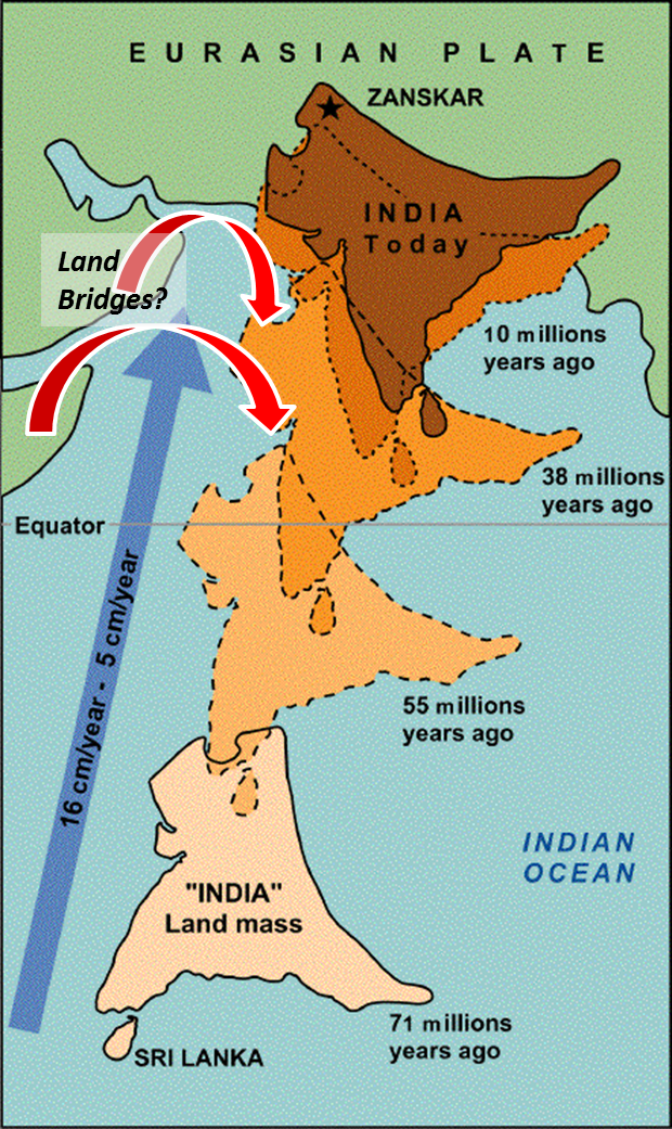
Essentially, as India (part of the Indian-Australian Plate) Broke apart from Pangea, it traveled along a subduction zone that included an ocean basin. As that Oceanic crust subducted, it brought the Indian plate into contact with the Eurasian plate, creating a suture between the two. On this suture formed Mt.Everest, and the rest of the Himalayan mountain chain. This type of collision is often described as the two plates being "Squeezed" together, so this would be an example of compressional stress. This also caused a shortening and thickening of the crust at this boundary.
The composition of the rocks on these two plates(and some of the remainder of the extinguished oceanic crust) also deserve some mention. It is observed that the Indian plate has moved inward into the Eurasian plate about 1200 miles (Ch.11 pg.309). Why did this occur, why was the Indian plate able to deform so much of the Eurasian continental crust? Because the Indian continent is a continental shield, it is formed of mostly very old(2 Billion years!), very cold, very mechanically strong rocks. whereas by contrast the Eurasian continental crust at the intersection was formed of much younger, much warmer (And therefore fluid/mechanically weak) rocks.
The composition of the very summit of Mt.Everest also belies the origins of this range. Samples of tropical marine limestone have been extracted which adds concrete evidence of the existence of an oceanic basin which was "uplifted" at the convergent boundary. As the tectonic forces of this collision ran their course, significant faulting and folding would have occurred, which can explain the significant displacement of rocks that were formally below, or at sea level. The faulting activity here would be most accurately described as thrust faulting (https://pubs.geoscienceworld.org/books/book/371/chapter/3796943/Active-faults-of-the-Himalaya-of-India-and-Nepal). After a full day of enjoying being outside, and recounting the amazing geologic history of this range, I turned my time machine back towards 2020, and left the himalayas beind.
Sources:
(https://pubs.geoscienceworld.org/books/book/371/chapter/3796943/Active-faults-of-the-Himalaya-of-India-and-Nepal).
Lutgens, Frederick K., Tarbuck, Edward J, and Tasa, Dennis G. (2018). Essentials of Geology, (13th ed). Pearson Publishing.
No comments:
Post a Comment