Friday, December 4, 2020

Week 7: Death Valley - Brandon Thammasine

I visited the Badlands Loop in Death Valley. The loop extends 2.7 miles and has an elevation of 535 feet. The area is filled with many wavy hills. The hills sort of has wavy ridges on the side which give them an interesting texture. I am as curious about how this geologic feature came to be. Were the hills created by compression plate movement? Or was it by erosion? I also notice a low number of loose rocks or visible broken pieces and harsh cracks in the formations. Why is that? Its sort of smooth texture is very interesting. What really amazes me is in some parts, I see some hills having colors of reds and greys in form of layers. Was this due to some form of plate bending? 


karl.de (@_karlde) | Twitter
The wavy hills of the Badlands loop in Death Valley. Taken by April. Death Valley: A Guide to the Highlights - The Unending Journey 


Week 7- Death Valley (Badlands Loop)- Tim Pester


A picture from Death Valley National Park. Off in the distance is the black mountains, and in the foreground is the wavy wife sandstone hills. 


Taking my virtue hike of Death Valley, I decided to walk the Badlands Loop. As I walk the white dirt path and looking around at the waving, white hills I first had to catch myself from thinking I was walking on a different planet. When I had a higher view of the horizon, the lack of vegetation or water was so apparent it just did not feel like the normal geological hikes I have taken. My first big question is how did this area form? As from the white hills contain sandstone, was this once a wet land? Did the black mountains, that contain metamorphic and igneous rocks, get thrusted into the sky cutting this area off from the ocean? With the lack of rain or a water source, was the main factor of erosion the harsh winds and does the wind factor in the wavy appearance of the hills? This is when the virtue tours or hikes become difficult, as I am not able to physically touch or examine anything to help answer my questions. I can just looks at all the pictures and enjoy the beauty of this unique and almost unearthly area.  

Wednesday, December 2, 2020

Week 7 Death Valley Hirra Faizi

 For my visit to Death Valley, I chose to view the Golden Canyon which runs to the Red Cathedral. The picture I tagged below was found from another source on the internet and I truly thought it was a beautiful and rather interesting image. As you can see from the image alone towards the back, it seems as though the rocks are deposited in an original horizontality manner as mentioned in Steno's Laws but I am not 100% positive about this. Also, since we recently discussed relative age dating, I would like to know how old these rocks are and exactly what kind of rock it is although after doing further research I concluded it may be sedimentary rocks where the color ranges from orange to gold to red as seen. 


                                                    Golden Canyon of Death Valley

                                                      source: shungphotography.com

Week 7 - Death Valley - Travis Suggitt

On a trip to Death Valley, I hiked to Zabriskie Point for a panoramic view inside the park. From there I noticed that nearly all of the ground is a smooth mass with individual rocks being nearly non-existent. The most prominent feature is large alluvial fans. At higher elevations nearby, the ground is darker brown while lower down, the ground shows lighter tan and yellow color. I would consider the shape of the fans to determine if the lower yellow ground previously covered the darker browns. Another possibility is that the darker reds are due to oxidation. Determining the mineral types of the different colored soil would be beneficial in figuring out their history. From the shape of the fans tells me what direction the mineral came from, giving me an idea of what existed "upstream" of Zabriskie Point.
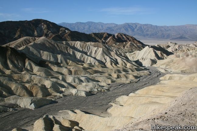
Looking west from Zabriskie point shows how sediment flowed to its current position (Smigelski, 2009).

The erosion that created the fans is appears to be from rare rainfalls in which the rain water moved quickly over land, transporting soil with it. The structures might be fairly young geologically speaking and the erosion recent, so searching the area for outcroppings that appear to be older could help determine what the newer alluvium is covering. This may not be possible in the immediate area as it looks like recently moved sediment in every direction!

The flow of sediment created a crazy landscape around Zabiskie Point (Todd, 2011).

Photo References:

Smigelski, S. (2009, November). Zabriskie Point in Death Valley National Park. Hikespeak. https://www.hikespeak.com/attractions/zabriskie-point-in-death-valley/

Todd, C. (2011, May 13). Zabriskie Point in Death Valley. Earth Science Picture of the Day. https://epod.usra.edu/blog/2011/05/zabriskie-point-in-death-valley.html

Week 7- Death Valley- Bridget B Mensah

After my trip to Death Valley, I found this picture that looks exactly like what I was mesmerized by on my stop. Looking at the photo brings up a few different questions. The main one being what types of sediments are in place. I’m guessing that there are metamorphic rocks there also but a geological map would help create an image of the geological events that happened in Death Valley. Being able to see where any faults, bending plates occurred could help piece together the history of Death Valley. Also having different rocks from different regions of the valley would also be helpful.


Photo Credit: Secrant.com

Tuesday, December 1, 2020

Week 7- Death Valley- Jazmine Jones

 In my visit to Death Valley I stopped and  viewed the Golden Canyon which leads to Red Cathedral. When I first saw the picture the first thought that came to my mind was what kind of minerals are these. The way the rocks are shaped it looks like it can be a Feldspar but I could be wrong seeing that I am not able to physically touch the rock. I would want to get a sample of the rock to test it. I would also like to know how old the rocks are and if the mountain rocks in the back are ocean- continent plates or normal faulting.


Wk 6 - Dustin

 Were I to be studying a certain location geologically, I would first request all information on any kind of human intervention and interaction with the area to ensure that I have an accurate picture on anything artificially changed. Next I would examine any current seismic activity to see what is currently happening. Finally, I would get my hands on all recorded natural events so I could try to identify any significant changes or perhaps trends that might align with the current geologic activity. I think with these three pieces of information I could make some educated observations on what I'm studying.