Sunday, July 28, 2019

Rausch-Week 4: Volcanos(Mt. St. Helens)

My wife and I decided to embark on a trip to Mt. St. Helens in Skamania County, Washington.  Upon arrival, we were awe-struck by how absolutely beautiful the surrounding area was.

                                                                 Mt. St. Helens 2016
Retrieved from
https://www.washington.edu/news/2016/11/02/new-study-co-authored-by-uw-geologists-looks-at-what-lies-below-mount-st-helens/                                                  


It was hard to imagine that such lush flora could prosper after the eruption that occurred back in May of 1980.  The Mt. St. Helens eruption of 1980 is still considered the most destructive and deadliest volcanic eruption in U.S. History.  Some of the statistics are truly shocking: 57 deaths, thousands of animals killed, 200 homes and over 185 miles of highway destroyed.  Another fact that I found truly phenomenal and terrifying was that the eruption of 1980 was actually 1600 times more powerful than the atomic bomb that was dropped on Hiroshima.
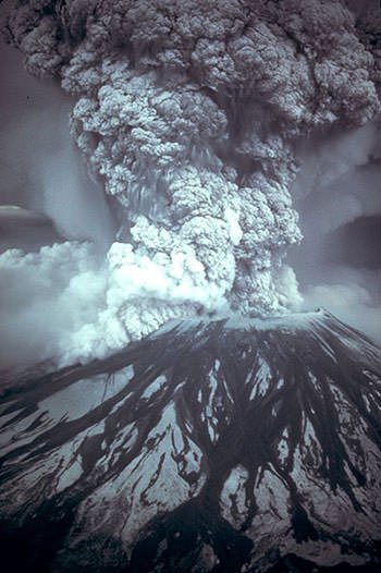
May 1980 Eruption
Retrieved from
 https://learnodo-newtonic.com/mt-st-helens-eruption-facts

My wife couldn't fathom that such a peaceful area could have been home to such catastrophe, so I was more than eager to offer her a lesson on the geology of Mt. St. Helens.  Mt. St. Helens is part of a chain of volcanic mountains known as the Cascade range.  This chain of volcanos, extending from southern British Columbia through Washington, Oregon, and northern California, is known for the highest seismic activity in the United States, so it is not really a matter of "if" but a matter of "when" Mt. St Helens will erupt again.  In fact, there have been minor volcanic activities that have occurred in recent memory: magma expulsion in October of 2004, an ash plume explosion in October of 2006, and steam and seismic activity occurring in January of 2008. The violence emanated from the eruption of May 1980 was preceded by a series of earthquakes and small explosions; as if the mountain itself was trying to warn everyone of what was about to occur.   A few geologic features that have emerged from the eruptions of Mt. St. Helens' 40,000 year history are the growth of a large dome as well as the appearance of glaciers(such as Crater Glacier).  

Crater Glacier
Retrieved from
glaciers.us/image-galleries/Crater-Glacier

Understanding Mt. St. Helens' volcanic history, my wife now understood why I was so insistent on taking a trip as soon as possible, lest we become witness to another catastrophe!


References

Bagley, M. (2018). Mount St. Helens Eruption: Facts & Information. Retrieved from https://www.livescience.com/27553-mount-st-helens-eruption.html

Hickey, H. (2016). New study co-authored by UW geologists looks at what lies below Mount St. Helens. Retrieved from https://www.washington.edu/news/2016/11/02/new-study-co-authored-by-uw-geologists-looks-at-what-lies-below-mount-st-helens/

Learnado. (2017). 10 Facts About The 1980 Eruption Of Mt. St. Helens. Retrieved from https://learnodo-newtonic.com/mt-st-helens-eruption-facts

USGS. (2019). Geology and History Summary for Mount St. Helens. Retrieved from https://volcanoes.usgs.gov/volcanoes/st_helens/st_helens_geo_hist_101.html


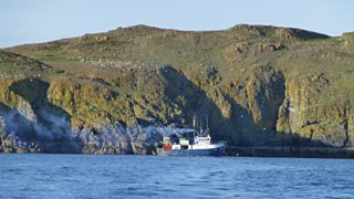


Lambay Island is an dormant volcano that sits opposite my home town of Malahide in Dublin Ireland. The island itself is privately owned and is not open to the general public. Lambay’s palaeontological record which documents the volcanic events in the construction of Ireland as we know it, makes this an important site.  The island is already recognised and protected as an SAC, partly because of the isolation which reduces threats to nature conservation. The geological heritage is equally significant.


Image result for lambay island geology


The island itself is important as an Ordovician volcanic complex. It forms one of several such complexes which resulted from the closure of the Iapetus Ocean and subduction of one tectonic plate beneath another. This took place around 450 million years ago, resulting in the two ’halves’ of Ireland joining together. The diversity of rock types include the well known Lambay porphyry – an attractive stone when polished for ornamental use. Of particular importance is the area around Kiln Point and Heath Hill, where a variety of fossils have been collected which provide evidence of the age of the rocks and of the environment at the time. Corals and other shells indicate a warm tropical sea around the extinct volcanic island. The island was important in the Neolithic period in Ireland as a ground stone  axe quarrying and production site.
Image result for lambay island
The Ordovician volcano that existed at Lambay during the period was similar to the modern day volcanoes in the ‘Ring of Fire’ around the Pacific Ocean. Lambay Island is an extinct volcano which was active during the Ordovician Period. Volcanic activity on Lambay during this Period caused the eruption of andesitic lavas. This activity was accompanied by instability and numerous submarine debris flows, which include black slates.


limestone reefs developed around the volcanic island, again with instability as the sediments are often slumped and disturbed. A rich fauna thrived in these limestones, and are now preserved as fossils in the rocks. At the end of the Ordovician Period, the sea level dramatically dropped as a result of a global glaciation event and the limestones were exposed, and a karstic doline (sinkhole) formed which is now visible in the cliffs, infilled with younger sediment. A series of unfossiliferous sandstones were deposited on top of part of the limestones during the Silurian Period. The more recent events seen in the record of the rocks include karstification resulting in two caves, and glaciation which levelled off the top of the cliffs.


Week 4- Volcano

Mount St. Helens

My family and I decided to visit Mount St. Helens in Washington. My children noticed that it appeared to be a mountain rather than a volcano as it had snow around the top. I explained to my children is not only is it a volcano, but it is an active volcano. It is so tall I explained because of the layers of ash and pumice it has acquired over time with each eruption. Its last great eruption had occurred in 1980. This explosion had caused damage where not only where things destroyed such as lumbar camps, but people had died. I told them not all volcanoes erupt the same way, however Mt. Saint Helens was an explosive eruption in 1980 due to an earthquake that causes a landslide which exposed the gas filled molten to lower pressure causing an explosive reaction. In addition, if the lava has more crystallization it will cause the lava to be thicker preventing gasses from releasing which also makes it more explosive. I then told my children volcanoes that are explosive are known as composite volcanoes compared to shield volcanoes in which lava flows down. My children looked at the surrounding trees and asked how this volcano emerged in this area. I explained it is not uncommon for volcanoes to come into existence in subduction zones where one plate is sliding under another. Specifically, Mt. St. Helens was created when the Juan de Fuca plate subducted under the North American Plate. My children looked at this huge volcano with amazement and came to the realization how even volcanoes can have great height and if active can still be very dangerous no matter how many years are between eruptions. 
An ash plume billows from the crater atop Mount St. Helens hours after its eruption began on May 18th, 1980, in Washington state. The column of ash and gas reached 15 miles into the atmosphere, depositing ash across a dozen states.
The Eruption of Mount St. Helens in pictures, 1980. (2017, October 28). Retrieved from https://rarehistoricalphotos.com/eruption-mount-st-helens-1980/ 

Saturday, July 27, 2019

Week 4 - Sinabung Volcano Indonesia

Sinabung Volcano Indonesia

This week my buddy and I went to visit one of the most recent volcanos to erupt called Mount Sinabung in Indonesia. On June 10th of last month this volcano unleashed a massive eruption. With this particular volcano  it produced such a violent eruption that ashes and cloud form called eruption columns. As pictured below, eruption columns were displayed and spewed from the crater of the volcano. There are many parts of a  volcano including magma chamber,  which is  where the magma is stored. Also when a volcano erupts it goes through a tunnel called the conduit leading to the vent of the volcano where it spews out. There are a few different types of eruptions called quiescent and triggering explosive. For this particular volcano it is a triggering explosive eruption rather than a quiescent type.


Work Cited
Imam, J. (2015, June 06). Sinabung Volcano erupts in Indonesia. Retrieved from https://www.cnn.com/2015/06/06/asia/sinabung-volcano-erupts-indonesia-irpt/index.html

Week 4 Etna Trip

For this week's travel journal, my wife and I decided to travel to Mt. Etna in Sicily, Italy. When we first got to Sicily, I got my first good look at Etna. It was the classic volcano cone shape, with visual paths carved out where lava had previously flowed, so I knew it was a composite volcano. I found this strand, as usually composite volcanoes are located along the “Ring of Fire” surrounding the Pacific ocean. As we got closer to the top, I saw black magma rocks, and no vegetation whatsoever. This led me to conclude that the volcano was fairly active, which was confirmed by the signage. There was a fair amount of steam coming off the top of Etna, so I knew she was active. I imagine this gas was due to the volatiles in the lava.  Judging by this gas, I would have to assume that the volcano is active and at risk of erupting. This was confirmed on our way down when I swear I felt the earth rumble. This is a tell-tale sign that eruption is near. Overall we enjoyed the trip, but I must admit I was relieved when we left.

 This was taken towards the top of Etna. You can really see here how baren the landscape is.
Another photo showing the steam coming off Etna.

Friday, July 26, 2019

Davidson Field Trip Travel Journal - Week 4 Entry

For my travels this week, I visited Pompeii and the volcano of Mt. Vesuvius.  The volcano is in Italy near the town of Naples.  It is located where it is because this is part of the convergent plate setting of the Campanian volcanic arc.  This volcano was formed over a subduction zone created by the convergence of the African and Eurasian plates.  The nature of past eruptions is evident here in Pompeii as the entire city was completely buried in volcanic ash following the eruption in 79 CE.  You can also see the crater that was left from the last eruption showing these eruptions were explosive.  It has erupted thirty times since then with the most recent in 1944.  Mt. Vesuvius is likely to erupt again because it is an active volcano and the faults continue to move.   We will measure the changes using ground deformation studies, and monitor seismic activities, to see if the ground inflates on the sides and if tremors occur more frequently to predict the next eruption.  According to an article by the Telegraph, “Italy's civil protection agency has drawn up an emergency plan, which envisages four levels of alarm being given, culminating in the evacuation, within 72 hours of 550,000 people living in 18 towns in a 200 square kilometre "red zone" ("Mount Vesuvius 'could erupt at any time'," 2013).  This obviously poses a significant hazard to the towns nearby.  “After the start of an eruption, residents of a larger "yellow zone" may be evacuated if ash fall and gasses released by the volcano create danger” ("Mount Vesuvius 'could erupt at any time'," 2013). When we look at the catastrophe in Pompeii, this was a result of ash and gasses.  That was a city in the yellow zone according to Italy's civil protection agency.  I found it interesting that people live on the sides of the volcano.  The guide also told us that people that lived on the sides of the volcano didn’t used to pay taxes because of that risk! 


Retrieved from http://www.geo.mtu.edu/UPSeis/images/plates.gif://

Retrieved from https://geology.com/volcanoes/vesuvius/

Retrieved from https://geology.com/volcanoes/vesuvius/

Retrieved from https://geology.com/volcanoes/vesuvius/

References

[image]. Retrieved from http://www.geo.mtu.edu/UPSeis/images/plates.gif://

Endsley, K. (n.d.). Where Do Earthquakes Happen?. Retrieved from http://www.geo.mtu.edu/UPSeis/where.html

image. (n.d.). Retrieved from https://geology.com/volcanoes/vesuvius/

Mount Vesuvius 'could erupt at any time'. (2013, September 6). Retrieved from https://www.telegraph.co.uk/news/worldnews/europe/italy/10291443/Mount-Vesuvius-could-erupt-at-any-time.html

Mount Vesuvius, Italy: Map, Facts, Eruption Pictures, Pompeii. (n.d.). Retrieved from https://geology.com/volcanoes/vesuvius/

Resource: Earth Revealed [Video file]. (n.d.). Retrieved from http://learner.org/resources/series78.html#


Week 4 - Volcanos

Amboy Volcano

 Credit: desertusa.com

During my family's many travels to Laughlin, Nevada we often passed through Amboy, Ca and would always look out for the Amboy Volcano. The Amboy Volcano is located in the Mojave Desert between the Bullion Mountains and the Bristol Mountains. This inactive, or dormant volcano, thought to have last erupted over 6000 years ago, is 250ft high and 1500 feet in diameter and stands out amazingly in what is a pretty flat and empty area. If the volcano was active today, I can't imagine it would do much damage, as this area is pretty barren, with the closet populated city being roughly 60 miles away.

Credit: desertusa.com

This explosive volcano was formed by volcanic eruptions along the northern border of the Bristol Dry Lake and pouring lava flowing onto its surface, dividing the area into the two present day playas. The Amboy Volcano is said to be an excellent example of a symmetrical volcanic cinder cone volcano.

Credit: desertusa.com

In 1973, the Amboy Volcano was declared a National Natural Landmark. This landmark, 1 of 20 volcanoes in California, is amazing to see up close. Having traveled and walked into the the crater, I can recommend this spot if ever you are in Amboy, Ca.