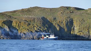
Lambay Island is an dormant volcano that sits opposite my home town of Malahide in Dublin Ireland. The island itself is privately owned and is not open to the general public. Lambay’s palaeontological record which documents the volcanic events in the construction of Ireland as we know it, makes this an important site. The island is already recognised and protected as an SAC, partly because of the isolation which reduces threats to nature conservation. The geological heritage is equally significant.

The island itself is important as an Ordovician volcanic complex. It forms one of several such complexes which resulted from the closure of the Iapetus Ocean and subduction of one tectonic plate beneath another. This took place around 450 million years ago, resulting in the two ’halves’ of Ireland joining together. The diversity of rock types include the well known Lambay porphyry – an attractive stone when polished for ornamental use. Of particular importance is the area around Kiln Point and Heath Hill, where a variety of fossils have been collected which provide evidence of the age of the rocks and of the environment at the time. Corals and other shells indicate a warm tropical sea around the extinct volcanic island. The island was important in the Neolithic period in Ireland as a ground stone axe quarrying and production site.
The Ordovician volcano that existed at Lambay during the period was similar to the modern day volcanoes in the ‘Ring of Fire’ around the Pacific Ocean. Lambay Island is an extinct volcano which was active during the Ordovician Period. Volcanic activity on Lambay during this Period caused the eruption of andesitic lavas. This activity was accompanied by instability and numerous submarine debris flows, which include black slates.
limestone reefs developed around the volcanic island, again with instability as the sediments are often slumped and disturbed. A rich fauna thrived in these limestones, and are now preserved as fossils in the rocks. At the end of the Ordovician Period, the sea level dramatically dropped as a result of a global glaciation event and the limestones were exposed, and a karstic doline (sinkhole) formed which is now visible in the cliffs, infilled with younger sediment. A series of unfossiliferous sandstones were deposited on top of part of the limestones during the Silurian Period. The more recent events seen in the record of the rocks include karstification resulting in two caves, and glaciation which levelled off the top of the cliffs.

No comments:
Post a Comment