Sunday, April 1, 2018

Week 3 - Running Water - Peter Hoffman

    The river that first came to my mind is the South Platte River.  Growing up in an urban environment, the Platte was the one big water source in my life.
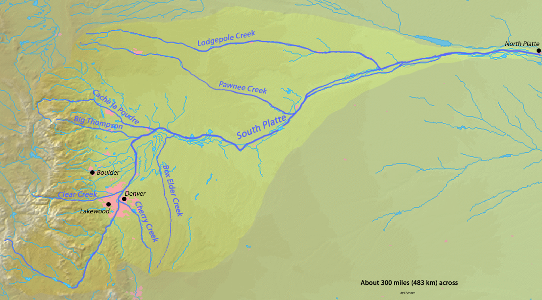
South Platte River watershed


As you can see from the image above, it meanders a little bit, but really seems to be mostly affected by human settlement.  I remember thinking it very odd that the river flowed north, and amazed that it went all the way and emptied into the Missouri.  The other main thing that I have always remembered about the Platte was how disgusting it smelled and looked.  I believe the main source of this is human driven, including pollution and damming that have altered it's appearance.  If my memory serves me, it seems to flow fairly moderately, with mostly smaller sediments found in the water (at least in the section of the Platte that I am used to that flows through Denver).
image courtesy of www.walktoconnect.com

Week 3 - Humboldt River, Nevada


"The Humboldt River can be divided geographically into an upper, middle and lower division based on Palisade Canyon and Emigrant Canyon being the major constriction points along the Humboldt River Valley. The upper basin begins in northeastern Nevada and drains about 5,000 square miles upstream from Palisade. The middle basin has a drainage area of about 7,800 square miles and lies between Palisade and Emigrant Canyon. The lower basin is an area encompassing some 4,100 square miles from below Emigrant Canyon and extending through the Humboldt Sink in northwestern Nevada. A hydro-logic definition instead divides the Humboldt River drainage into two basins—one above and one below Palisade—based on flows that increase above and decrease below this part of the river. The river in the upper basin is 92 miles (148 km) long and in the lower basin it is 218 miles long. The major tributaries of the upper Humboldt River basin are (heading downstream) Bishop Creek, Mary's River, Lamoille Creek, North Fork Humboldt River, South Fork Humboldt River, Susie Creek,Maggie Creek and Mary's Creek; and of the lower basin they are Pine Creek, Reese River, and the Little Humboldt River.

The source of the river main stem is a spring called Humboldt Wells at the northern tip of the East Humboldt Range, just outside the city of Wells. The river flows west-southwest through Elko County past the communities of Elko and Carlin. Approximately 15 miles (24 km) upstream from Elko, the river receives the North Fork of the Humboldt River, and receives the South Fork approximately 7 miles downstream of Elko."


Fishing Information:

I have been here with my grandpa and uncle fishing in 2012. I am not much into fishing, but my uncle loves to go all the time. I went on vacation to visit to see a band play at a local casino and my uncle thought it would be good to take in a day of fishing. I enjoyed it very much, much to my surprise. There were quite a few people fishing, a lot of families. We caught a few fish, but put them back. We went for the relaxation and quiet time to just hang out.

Flows in the river fluctuate between 13 and 700 cubic feet per second. The primary species found in this section of river include white crappie, wipers (white bass x stripper hybrid), channel catfish, large-mouth bass, small-mouth bass, walleye, brown bullhead, bluegill, green sunfish, and yellow perch. The best time for fishing has proven to be from early May through early July. The effective fishing methods include bottom fishing with night-crawlers and live bait as well as using small crappie.

http://www.ndow.org/Bodies_Of_Water/Humboldt_River/for permission to access the river or to camp. (
The Mojave desert

This past Spring Break I flew to California for the first time . I wanted to get out east coast for a change. I didn’t want to go to the popular areas, like Los Angeloas or San Francisco’s I traveled to the Mojave Desert instead. The Mojave isn’t your typical desert . It has a typical mountain and basin topography with minimal vegetation. This desert is in between the hot Sonoran desert and the coole and higher Great Basin . The Mojave Desert is a rain shadow desert. This is due to latitude, elevation, geology and indicator plants. 
This desert salons has the lowest absolute elevation and the highest maximum temperature. This desert occasionally grows catlaws along the arroyos . It hosts about 200 endemic plant species . Creosote Bush , Shadscale, Big Sagebrush , Bladder- sage , bursages and Blackbush are common vegetation found .

Week 3- Rivers

Rio Grande River

My family and I went to Texas last summer . While driving on the long roads we seen the Rio Grande River . As we were driving the river seemed to never end . It is nearly 2000 miles ! It is the fourth longest river system in America . I’m 1848 it marked a boundary between Mexico and the United States . This river is formed by the joining of several streams , east of the continental drift . Then it flows through San Luis Valley and goes south towards New Mexico .
In New Mexico the river flows through the Rio Grande Rift from one basin to another . It cuts canyons between each basin . The Rio Grande also known as the Rio Bravo del Norte runs through the Rocky Mountains into the San Juan Mountains finally back to the Gulf of Mexico . This river is very beautiful to look at if you are going to Texas.

Flying along the Arkansas River


Here’s the honest-to-god truth about a trip i took to the Arkansas River...

I was craving adventure a wanted to explore something id never seen before. So i got my drone out and flew on it to survey the Arkansas River.   Here is an actual high-resolution photograph of me just after take off...


I flew first, at 750mph to the start of the Arkansas River which is in the rocky mountains near Leadville.

The A.R. is the sixth longest river in the United States measuring almost 1500 miles. As i soared high into the mountains i noticed that the river becomes rather large rather quick. The riffles between bends here are fairly long and the discharge in the mountains is about 2900 cfs.  Depending on the snow pack that year, the A.R. has mean overall discharge of 41,000 cfs so you can see that it becomes quiet large over its run.  
Here in the Rockies the river is known for its class 3-5 rapids and is home to many people of questionable disposition who kayak and raft these dangerous waters....questionable disposition, not like me flying safely on my sub-sonic drone.


As the river meets a gentler grade, it gains width and slows in speed. it is the Arkansas river that Flows through Rocky Ford Colorado and is the main supply for the famous Rocky-Ford Cantaloupes as well as other fruit farming that takes place is south eastern Colorado.  


The A.R flows through four states, the last of which is Arkansas, before flowing into the great Mississippi River of which the A.R. is therefore a tributary.


Here i ended my journey by touching down on a barge...hopefully they will let me power my drone back up so i can be home for dinner. From Rapids, to watering farms, and now finally assisting in the huge discharge required to make freight transport by boat real, the A.R. ends its particularly productive run.

Week 3 - Glaciers

A couple years ago my buddy and I decided to go rock climbing in Yosemite. My buddy happens to be a geology major so while we were taking a break he got into a spirited lecture about the geological history of the valley. Apparently Yosemite Valley was formed by an alpine glacier as evidenced by its shape. Typically mountain valleys have a relatively narrow v shaped bottom however when a glacier passes through it widens and narrows the bottom leaving a u-shaped trough like the one here in Yosemite. He went on to say that the reason why some of the granite rock faces looked so polished is because as glaciers move they carry along a lot of  grit with them so they essentially act like sand paper and smooth out any geological features in their path.

After two hours of listening to my buddy talk about geology I started getting very restless and politely reminded him that we drove all this way to climb rocks, not talk about them.


https://prd-wret.s3-us-west-2.amazonaws.com/assets/palladium/production/s3fs-public/styles/atom_page_medium/public/Yosemite_Valley_in_Fog.JPG?itok=eLncSYh1
                                                Yosemite Valley
https://prd-wret.s3-us-west-2.amazonaws.com/assets/palladium/production/s3fs-public/styles/atom_page_medium/public/Yosemite_Valley_in_Fog.JPG?itok=eLncSYh1

Week 3 - Running Water

The Panará River is a 3,030 mile long river that runs through Brazil, Paraguay, and Argentina. It is the second longest river in South America that also meets with the Uraguay and Paraguay rivers to make up the Río do la Plata. These rivers all form a drainage basin that is beneficial to the countries they run through, as . They also are a source of water for the Atlantic Ocean. There are also some damns throughout the river, allowing for upstream traveling of boats that carry imports and exports.


The river has a laminar flow due to its size and discharge. The headwaters of the Panará River are in Brazil and the mouth is at the Río de la Plata, near Buenos Aires, Argentina. This long stretch of water provides many fish for the fishermen of the countries it runs through. It is also a prime bird watching spot.