On day 2 of the Jeep Jamboree trip of the Rubicon trail consisted of vehicle maintenance and a little bit of swimming. The vehicles and campsite were at Rubicon springs right next to the Rubicon river.

https://i.ytimg.com/vi/AnGWUOEQF-o/hqdefault.jpg
The Rubicon river is a drain for the western flank of the Sierra Nevada. Starting at an elevation of 8700 ft, it runs about 60 miles mostly running NNW and has a watershed of about 184 sq. mi. It carves it way through the granite rocks creating a valley 58 ft deep in some areas. by doing this it started showing some of the layers that make up the mountain range.

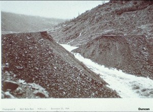
The river used to meander in the valley until it was diverted for hydroelectric dams. On December 23rd, 1964, the river flowing at max discharge. The surge wave carrying Alluvial deposits, of both Pleistocene and Recent
age, colluvium, including material from landslides
triggered by the surge, soil, and bedrock, broke the Hell Hole dam.

https://research.engineering.ucdavis.edu/gpa/wp-content/uploads/sites/43/2015/02/Failure-of-Hell-Hole-Dam-P03-300x220.jpg
https://upload.wikimedia.org/wikipedia/commons/thumb/9/92/Rubicon_River_flowing_through_cataract_to_Hell_Hole_Reservoir.jpg/603px-Rubicon_River_flowing_through_cataract_to_Hell_Hole_Reservoir.jpg
No comments:
Post a Comment