Sutter Buttes, California
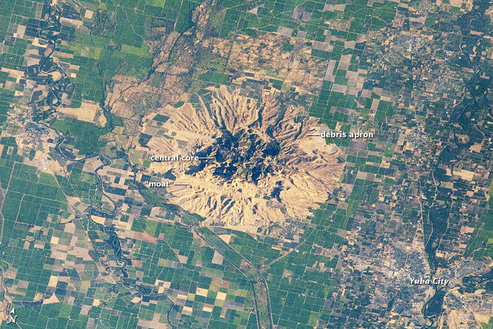
One of the most interesting ancient geological formations in California is located in Sutter County which features the Sutter Buttes. This outcropping of earth was created from an ancient volcano. The central hills were developed from lava flows directly and the apron surrounding the main hills spread from the center as a result of rock material carried by volcanic gasses. The rock material surrounding the buttes over time have eroded into a thick loam soil that has supported a healthy agricultural presence around the apron.
 |
| Sutter Butte Overhead (NASA, 2012) |
In order to better understand an area, you have to read between the lines. The data points that would be most important to paint an accurate picture of Sutter County would be:
- a list of the plants and animal remains found in the various layers of the apron. This will help to better understand the periods of time when certain large eruptions occurred.
- a comprehensive analysis of the minerals in the valley because this will help determine whether there are factors other than the volcano that have been significant in the makeup of the valley.
- a map of the fault lines to better understand the way that the landscape had contributed to the volcanic activity throughout the history of this county.
Understanding those three elements will lead to a much richer evaluation of this part of the complicated geological puzzle that is California.
Sources
Lutgens, F. K., Tarbuck, E. J., & Tasa, D. (2016). Essentials of Geology (13th ed.). Upper Saddle River, NJ: Pearson.
NASA. (2012, July 29). Sutter Buttes, California. Retrieved November 30, 2018, from https://earthobservatory.nasa.gov/images/79049/sutter-buttes-california
No comments:
Post a Comment