Sunday, June 28, 2020
Week 2: Field Trip Travel Journal
This week I took a trip to California. Below, you can see the Granite Boulders, in Joshua Tree National Park. Igneous rocks are formed when hot, molten rock (magma) crystallizes, and then solidifies. Magma that rises to the surface is called Lava. Igneous rocks can be classified into two groups depending on where the molten rock solidifies, the rock can either be classified as Extrusive, meaning: when the magma reaches the Earth's surface, then cools quickly. Or you can classify the rock as Intrusive, meaning: rocks that crystallize below the Earth's surface which allows for slow cooling to form small crystals.
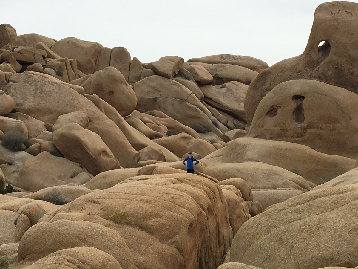
The most common type of rock found in Joshua Tree, is Gneiss. Gneiss is a high grade metamorphic rock, which means that the rock itself is coarse unlike the rocks picture above which are most likely low-grade formed due to their smooth texture. Overall, Joshua Tree, looks gorgeous and I would love to have been the person in this picture as I would love to run and climb up those large boulders.
Week 3: Deserts
Palm Desert, I have never visited but I hear that it's unlike what you would ideally think of when you hear the word, "desert." I know very little about Palm Desert, expect that Coachella is annually held there and that is another topic that I know nothing about. So this field trip will allow me to learn more about Palm Desert.
According to the Palm Desert site of California it was incorporated November 26, 1973. The city of Palm Desert is noted as one of the safest cities in Southern California. Palm Desert is sheltered from coastal air pollution and inclement weather, there are 350 days of sunshine a year. In July the average temperature is a high of 107 and a low of 74 (still incredibly cooler than that of its fellow California resident, Death Valley).
There are no adjacent offshore cold oceanic currents. The palms highway is surrounded by a ring of high mountains that were created primarily by uplift along faults. Overall, a trip to Palm Desert was more enjoyable than that of Death Valley.
Week 4: Volcanoes
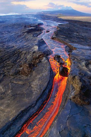
Mauna Loa is the destination for this week and I am excited!
According to the USGS, he Hawaiian name "Mauna Loa" means, "Long Mountain" The volcano was given its name because of how far it extends, which is approximately 74 miles from the southern tip of the island to to the east-northeast to the coastline near Hilo.
USGS states that, "Mauna Loa is among the Earth's most active volcanoes, having erupted 33 times since is first well-documented historical eruption in 1843. It has produced large, voluminous flows of basalt that have reached the ocean eight times since 1868. It last erupted in 1984." The volcano is carefully monitored due to to its past volatility. A side note that I thought was interesting, but makes complete sense - those who live in Hawaii and are property renters or owners must attain volcano insurance, which I'm sure for a native, the thought of a Volcano erupting doesn't cross their mind all day long, but myself I would be scared - I'm sure for no reason, but I thought that was interesting.
Week 5: Converging Plates
The Cascade Mountains are a great example of convergent-plate margin. Oceanic convergent-plate margin to be specific. Aligning with the below figure, the volcanoes of northeastern California, along with the rest of the Cascade Mountains of the Pacific Northwest, are the result of subduction of the Juan de Fuca plate due to the spreading of the seafloor. What I find so interesting is that of Alfred Wegener, he believed that the Earth's gravitational pull was the reason for plate movement, when really due to weathering, erosion, and the spreading apart of the seafloor and expansion of the Earth's crust are really what leads to plate movement - which additionally can lead to volcanic eruption.
The stress which aided in the creation of the Cascade mountains was due to compression stress. Due to this igneous rocks are most commonly found in the Cascade mountains.
Week 6 - Geological Interpretations
The Granite Quarry in California looks so interesting! Slate, Granite, and Marble can all be found here. To further my exploration and scientific research, I would need the some at least a couple of tools. I would choose a chisel, mallet, and a boring tool to allow me to drill into the rock formation in order to collect different layers of a sample.
The data that I would request were any backlogged data from past explorers, I would also like to know how long ago was this quarry actively worked on by quarry men, I would also like archived newspaper articles - as this would allow me to date information back to with photos, this will show me what the quarry originally looked like and how weathering and erosion have since changed it over time.
Week 7: Death Valley
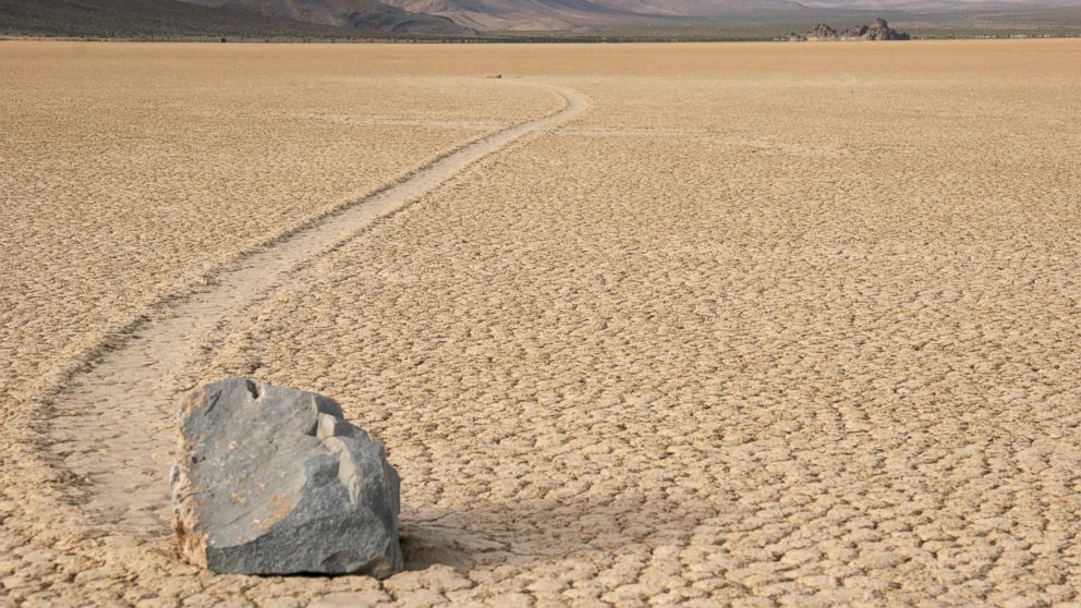
Death Valley is known as the driest in the country. What a record, in the year 1929, there had not been a drop of recorded in Death Valley. Archaeologists have even found human presence in Death Valley to possibly date back 9,000 years. Pictured below, is one of the "Mysterious Moving Rocks," according to the National Park Service website, research has suggested that a rare combination of rain and wind conditions allow the rocks to have just enough of a slippery surface to move and leaves trails of where these heavy rocks once were. Overall, this was to hot of a trip for me, hopefully our next trip into the future is somewhere with air conditioning!
Week 8: Global Warming
Additionally, livestock is no longer a source of food, fish and other seafood is abundant
Global Warming Week 8
Week 8 - Global Warming
Woke up in a random pod
again. Phone was dead so I staggered outside to see what time it was. I opened
the door and got blasted with extremely hot wind. Everything looks different,
futuristic yet desolate. I walk to the nearest internet café to figure out what
is going on. I finagle my way to finding the news on one of these new computers
that sit before me.
First thing I find is
the weather for the day, Denver, Colorado, January 23rd, 7010 sunny with a high
of 112. Main article is talking about the best vacation spots for your winter
break. I see places like Fairbanks, Alaska and Antarctica describing their
wonderful beachside resorts and mild temperatures. It gets me curious, so I
keep digging. I find a few more articles. One talking about any land mass within
the Tropic of Cancer or Capricorn are either underwater or way too hot to
sustain life. Water had rose thousands of feet because of the Polar Ice Caps
melting.
We lost the battle with
Global warming. The world was too dependent on fossil fuels and methane
producing livestock to combat the problems in the future. Most people have
either moved to the Artic or Antarctic Circles to stay away from the heat.
While some stayed and confine themselves to a refrigerated home during the
summer months. This is the future we have to look forward to.
Saturday, June 27, 2020
Global Warming - Nature Cycles (Outer Banks, NC)
Friday, June 26, 2020
Week 8 Global Warming
The year is 7010, my time machine glitches and I ended up in
a place I’ve always wanted to visit. Little did I know it would’ve looked like
this five thousand years later. During my accidental travels I ended up in the
Bahamas. The Bahamas was made up of seven hundred (700) islands and cays
stretching from Abaco in the North to Inagua in the South. I’m writing my
journal sitting on the highest point which is Mount Alvernia in Cat Island.
This hill is 206 feet which is considered high because the Bahamas is below sea
level. The Bahamas is situated in the hurricane belt, leaving the nation
susceptible to dangerous storms. In 2020 the catastrophic storm by the name of
Dorian flattened the Island of Abaco and destroyed a major portion of Grand
Bahama. Dorian was just a taste of what would the years would hold.
Observing my surroundings the majority of the islands have disappeared. The
Southern islands have been covered by sea water and islanders had to relocate
further up the chain. Once known for sun, sand and sea the country is now
slowly being covered in water. The Bahamas is a Small Island Developing State
(SIDS), which are a group of countries that share sustainable development
challenges; for example small populations, limited resources, remoteness,
susceptibility to natural disasters, vulnerability to external shocks,
excessive dependence on outside countries. As a result of this, The Bahamas has
encountered the adverse effects of climate change although they were small
contributors. Extreme storms continuously knock at the boarder and the seas
have no regard for boundaries.
The world carried on with business as usual when their counterparts needed them
desperately. They didn’t care about their carbon footprint or how it would
impact the future. Anthropogenic actions far outweighed natural causations and
global warming occurred. Global temperatures have exceeded what scientists have
predicted and the effects of such were drastic on this archipelago.
The Bahamas was such a serene place for visitors, now it’s just a country being
taken over by water day by day. The citizens of Cat Island have adapted to such
drastic changes and kept up the constant fishing and farming where they
possibly can. The domestication of wildlife has occurred and Islanders have
become one with nature. Daily swimming to catch fish and to train the younger
islanders how to do the same.
Who would’ve imagined an island destination would’ve turned to this?
Week 8 - Global Warming
Thursday, June 25, 2020
Week 8 - Global Warming
The woman began by describing what had caused this global warming event, stating that the grandest of all contributors were the anthropogenic effects, such as enormous amounts of livestock farming and atmospheric deposits from transportation vehicles burning fuel. All of these factors contribute more carbon dioxide into the upper atmosphere, blocking more of the Sun's heat energy in the lower atmosphere. The woman went on to state that the pleas of the people fell on deaf ears of Congress for decades, calling for regulations of the private business industry to focus on cleaner, more green-efficient methods to produce food and utilize energy. It appears that the masses were endorsing EVs, nuclear power plants and alternative food sources based on plants. However, those in charge of creating a new order for its constituents to abide by took no action and continued on with their traditional way of life. Not once were any "natural" causes mentioned in the clip. As I left the television station, I slipped the clip into my pocket as a souvenir, in hopes that evidence of the future would sway the leaders of my time to consider how their present ideologies can affect the entire future of the world and its people within.
Wednesday, June 24, 2020
Week 8 - Myrtle Beach Global Warming
source: https://www.newsobserver.com/news/local/article217026850.html
Although we initially failed to limit carbon emissions to the point needed to avoid global cooling, we responded vigorously. The United States Government made a determination that in order to combat this and save our species, we needed to view this as a two step process.
1. Eliminate carbon emissions to mitigate global cooling.
2. Create physical barriers to protect from the failure of #1.
Everything was converted to clean energy, yet sea levels continued to rise. The damage had already been done. Our government made an all in effort to create barriers around our coast lines. Essentially the entire country banded together in an event that will be recorded in history forever. Citizens from all over the country filtered to our coast lines and water inlets. Imagine the United States citizens filtering from the middle of the county to the outer edges. The mitigation efforts from #1 allowed them enough time to build an initial levee barrier. Similar to those used in New Orleans yet on a much larger scale. Of course this took a lot of time but thank god the people we early enough to get this done. Myrtle Beach and all of America is now protected by there barriers. The combination of 1 & 2 saved our existence. However the work continues. One barrier is not enough to protect man kind. They continue to build barriers inland to using a honeycomb methodology from the initial barrier. This will ensure we are still protected from weak points, ruptures or overlooked maintenance over time.
source: https://www.argosyinternational.com/products/honeycomb/
Although life has changed exponentially in 7010, I am hopeful. The American people were able to come together in a time of need to save our land and save our people. This my friends is the foundation in which our county was built upon and the mindset which will secure our future forever.
Tuesday, June 23, 2020
Week 7 Death Valley
Blue Ridge Mountain Week 7
Sunday, June 21, 2020
Week 7 - Badwater Salt Flats
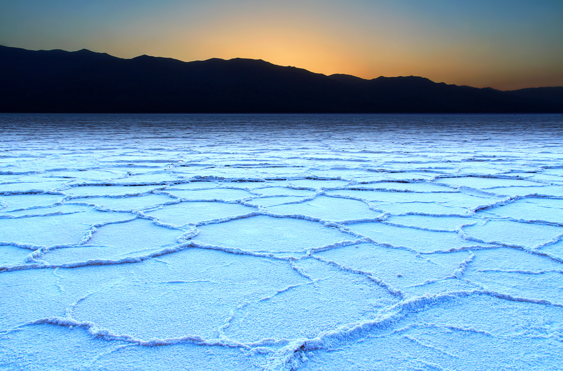
These magnificent flats would surely posses no way to drain out if below sea level, and the cracked surface of the flats is further proof that evaporation is part of the process in creating this wondrous basin. However, that's just part one of my observation! The second part regarding elevation includes the altitudes of the mountains in the background of the photo, or the Black Mountains. If we know that there is no way for the basin to drain out, and there is little precipitation in this area year-round, where is the salt coming from to build up? Precipitation falling on mountains such as these, and other distant hills, creates floods; along the way down, salt minerals dissolve from rocks in the flood waters. Finally, the floods reach the basin where the water evaporates until only the sodium chloride remains, however, there are other minerals (calcite, gypsum, and borax) present in the various layers of salt. Since the basin doesn't drain at all, detecting what other minerals remain is vital to understanding the geological make-up of the mountain and hills surrounding the area. It's a sure-fire method to creating geological maps of Death Valley for future scholars to utilize in their studies!
Crust layer of sodium chloride formed in the basin of the Badwater Salt Flats, located in Death Valley.
Source: https://elevation.maplogs.com/poi/badwater_ca_usa.98798.html
Week 7 - Badlands Loop
At the location I stopped to visit was the Badlands Loop with
its unique rock structures and patterns in the rocks. This area of the desert stood
out to me for the beautiful rock designs. For the purpose of construction a geological
map would require knowledge of the rocks, analysis of folds, joints and faults caused
by plate tectonic movements. An observations of the folds indicates to me that
a significant number of lava intrusions from below caused the formation of the
rocks. The geology of Death Valley is interesting, as there is not much
vegetation on the rock formations. What factors in the geological process has
caused this area to sink below sea level over time?
Saturday, June 20, 2020
Week 7 - Death Valley Artist's Drive
Thursday, June 18, 2020
Week 7 - Death Valley - Mesquite Flat Dunes
source: https://www.nps.gov/tripideas/extra-few-hours-to-explore-must-see-spots-in-death-valley.htm
These are the largest Dunes in the Death Valley National Park. The dunes are comprised of sand which has collected over time. It takes a source of wind to carry the sand. One of the things I question is what is the source of this sand? And how does it continue to keep a constant supply which elevates the dunes? In order to answer these questions a geological assessment of the area and review of a topographical map would likely identify the source of the sand. This should allot me the opportunity to understand the source of the sand.
Wednesday, June 17, 2020
Death Valley - Badwater Basin Salt Flats
Week 7 - Badlands, Golden Canyon and Gower Gulch Loop
Monday, June 15, 2020
Week 6 Geological Interpretation
One method of completing a geological interpretation
is the use of structural geology. This is the analysis of folds, joints and
faults within the rocks caused by plate tectonic movements. Information
obtained from the folds and faults assists in the creation of geological maps
of the area. Knowledge of the condition and the shape of the surface of the
land, type of rocks exposed and age are key factors in the completion of a geological
interpretation.
Sunday, June 14, 2020
Week 6 - Geological Interpretation
Vesicle traits from a specimen taken from Modoc National Forest, CA.
Source: http://www.maryhemmerlyhecker.org/sand-collection-archive/064-big-sand-butte-modoc-national-forest-ca/
An example of flow banding formations.
Source: https://www.usgs.gov/media/images/flow-banding-panum-pumice-and-obsidian
Week 5 Converging Plates
Appalachian Mountains Week 6
Geological Interpretations: Humboldt County Interpretation Resources
Saturday, June 13, 2020
Week 6 - Geological Interpretation
Friday, June 12, 2020
Week 6 - Sierra Nevada Mountains - Geological Interpretation
source: https://muir-way.com/products/sierra-nevada-mountains-map
source: https://maps.conservation.ca.gov/cgs/fam/
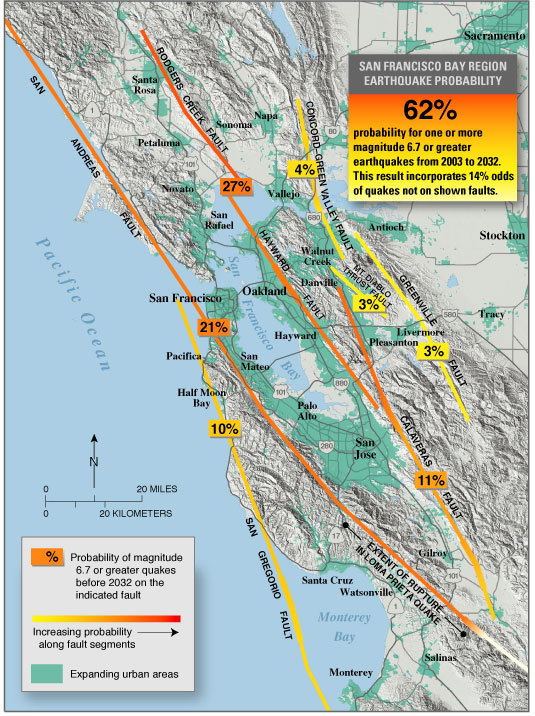
These active faults have cause the mountain range to move up over time. There is much debate over how old this mountain range may be. It has originally been thought that the mountain could have been experiencing its uplift as soon as 3 to 5 million years ago. However there are recent studies from fossils which suggest that the Sierra could have been formed 40 million years ago. This would be during the Eocene time.
To aid helping this debunking this I believe I would need the following pieces of information. I would want to study the superposition in order to interpret the geological time frames. I would also like to study the current erosion from the mountain to try to draw chronological time correlations. And lastly I think we need to analyze the fossils in depth using as many of the new dating technologies.
Week 6 - Geological Interpretation
Wednesday, June 10, 2020
Week 5 - Converging plates
Friday, June 5, 2020
Week 5 Converging Plates
The convergent plate margin visits would be the Peru Chile
Trench, where you have a subductive zone of Oceanic crust (Nazca Plate) against
continental crust (South American Plate) and the formation of what is known
today as the Andes Mountain range.
Here, the two plates are involved in a compressive type of
stress where the plates move toward each other. When a collision occurs, the
oceanic crust sinks under the light continental crust because it is denser. The
molten rock rises to the earth’s surface, resulting in eruptions and the
formation of mountain ranges.
Intrusive rocks like granite and granodiorite which are
resistant to corrosion are normally deposited and form the core of the
mountains (Andeansummits.com).
In the Andes Mountain regions we can see where folding is
taking place and dominating the structural style. This is where the pressure of
the converging plates cause the crust to fold, resulting in the creation of the
mountain ranges.
Faults occurring along this region are normal faults.
Reference:
Andean Summits (nd). Geological history of the Andes.
Retrieved from https://www.andeansummits.com/geological-history-andes#:~:text=Intrusive%20rocks%20such%20as%20granite,over%20the%20surrounding%20sedimentary%20rocks.
Week 5 - Converging Plates
Thursday, June 4, 2020
Week 5 - Converging Plate Andes Mountains
Source: https://www.explore-share.com/blog/exploring-andean-heights-cerro-mercedario-expedition/
The Andes were mountains formed from converging plate boundaries. More specifically ocean / continent boundaries. This is where the ocean boundary sinks below the continental crust. The Nazca plate has been subducting the South American plate for about 45 million years and continues to do so today.
Source: https://www.haikudeck.com/plate-tectonics-by-hannah-parmertor-uncategorized-presentation-p0xOuQ6gUq#slide6
Due to the factors of these converging plates I would consider compressional stresses to be a factor. Which causes the deformation that allows for the folds. Essentially the Andes are considered fold mountains. The Andes is also dominantly composed of Andesite which derives its name from these mountains. The andesite is a product of the volcanos which reside in the Andes mountain area.