Tuesday, April 30, 2019

Week 8-Global Warming (Natural Cycles)-Gabbie Ramirez


Global Warming (Natural Cycles) in Melbourne, FL

           In the year 7010, the first people to move into Florida were the Paleoindians. At that time, the end of the last Ice Age, Florida was twice the size it is today, (State Library and Archives of Florida, 2019). Ever since humans stepped foot anywhere on Earth, including Florida, there was bound to have some effect on the environment. Traveling back, I found that the later presence of Floridians is what contributed to future issues with Global warming today. However, there are some forces of nature due to geological formations that add to the later effects of climate change.
Graph showing the rise in Florida's sea level from 1950-2016.
Credit to: https://sealevelrise.org/states/florida/

              Recently, Florida’s sea level is rising and it’s costing over $4 billion dollars. There are already 120,000 properties at risk from frequent tidal flooding in Florida, (SeaLevelRise.org, 2019). The sea level around Florida is up to 8 inches higher than it was in 1950! (SeaLevelRise.org, 2019). Its speed of rising has accelerated over the last ten years and it’s now rising by 1 inch every 3 years, (SeaLevelRise.org ,2019). While there are several causes that contribute to this mess, the biggest reason why sea levels are rising is because of the North and the South Poles and slowing of the Gulf Stream. Not only that but the complicated limestone that the state sits on is letting water seep in, causing sea walls to be useless.


These graphics show the difference between Florida’s foundation and a typical coastal foundation. Limestone lets the water through while a typical coastal wall blocks out the sea water.
Credit to: https://sealevelrise.org/states/florida/

              
           As centuries passed, hurricanes and tropical storms have increased.  Why? As the ocean surface’s warm-up, there were stronger storms, (Climate Change and Florida, 2019). As the sea surface becomes warmers, hurricanes become more powerful. Thanks to Florida’s geography, relatively flat peninsula, jutting out into the Atlantic Ocean and Gulf of Mexico – leaves it especially vulnerable.

         Since 1970, temperatures in the US Southeast have risen by an average of 2 degrees Fahrenheit, with even higher average temperatures striking in the summer months, (Climate Change and Florida, 2019). If current trends continue, temperatures in Florida are “expected to exceed historical records by about 9°F by the end of the century, “(Climate Change and Florida, 2019). 

          As you can see, Florida is feeling the effects of climate change. While the natural causes of Florida’s geological format are a contribution, human beings have also added to the stress. This rapid warming trend cannot be explained by natural cycles alone, scientists have concluded, (National Geographic, 2019). Current levels of the greenhouse gases carbon dioxide, methane, and nitrous oxide in our atmosphere are higher than at any point over the past 800,000 years, and their ability to trap heat is changing our climate in multiple ways, (National Geographic, 2019). Most come from fossil fuels in cars, buildings, factories, and power plants. Other givers include methane released from landfills, natural gas and petroleum industries, and agriculture nitrous oxide from fertilizers; gases used for refrigeration and industrial processes; and the loss of forests that would otherwise store CO2, (National Geographic, 2019).
             
           There are several articles that state Florida will be “wiped off the maps.” It’s scary to think that such a place will be gulped up by the sea. It’s hard to say what can be done for Florida’s geological makeup. However, as the other contributors, we need to do our part to not make this mess even worse!

           The renewable revolution is ongoing across the country (and around the world). Solar energy is key to that clean energy future, (SeaLevelRise.org, 2019).  The solution is clear: The best way to create new jobs and grow the economy, fight climate change, and support a sustainable future for the planet is to invest in renewable energies like solar! (SeaLevelRise.org, 2019). 


What are your ideas? 


References:
SeaLevelRise.org. (n.d.). Florida's Sea Level Is Rising. Retrieved from https://sealevelrise.org/states/florida/


Causes of Global Warming. (2019, February 27). Retrieved from https://www.nationalgeographic.com/environment/global-warming/global-warming-causes/

Climate Change and Florida: What You Need to Know. (n.d.). Retrieved from https://www.climaterealityproject.org/blog/how-climate-change-affecting-florida


State Library and Archives of Florida. (n.d.). Timeline. Retrieved from https://www.floridamemory.com/exhibits/timeline/


Abdul - week 8 - Global Warming


Global Warming
Miami is not the beautiful coastal city it was years ago. Most of its beauty is now covered with water from the sea thanks to global warming. Looking back the humans are to blame for the current status. Greenhouses continued to be put up despite the constant warnings of the effects that came with it. The gases from the greenhouses were being discharged into the atmosphere making the oceans to moderate the effect (National Geographic, 2019). The oceans continue to take in the heat but as it appears, no more heat can be taken, and the oceans have now swelled and busted. What the global society failed to do is to insist on the effects of greenhouses and better yet physically go to the sites where the houses were constructed and ensure the construction was stopped. It also looks like our global society chooses to include the government and other authorities when it was too late.
The anthropogenic effects of global warming were dominant to the natural contributions to global warming. The melting glaciers increased with time. Summer periods did record an increase in the melting of mountain glaciers (National Geographic, 2019). Furthermore, snowfall continued to decrease with each winter season. The water run-off could no longer balance with evaporation because more water was coming into the ocean and little going out. This difference also led to rising sea levels.  After 5000 years of being warned about possible global warming, the time has come, and global warming is happening. The society in the hope for moderation has pulled down all the greenhouses, they have planted trees and even resolved to use bicycles in place of cars as ways of preventing the emission of gases that harm the ozone layer. The consequences are however notable because the beautiful Miami beach is now inaccessible.


References
National Geographic. (2019, January 17). Causes of Global Warming. Retrieved from https://www.nationalgeographic.com/environment/global-warming/global-warming-causes/


Monday, April 29, 2019

Week 7: Death Valley

I have driven through Death Valley, but I never really slowed down to appreciate it until recently. The area is so diverse. I just expected Death Valley to be a empty dessert with not much diversity. After reading and doing virtual tour of the area, I was quickly proven wrong. My favorite area was the Devils Golf Course. It is a salt pan that Is located in the Mojave Desert area located within Death Valley National Park. I assume this is on the edge of the valley, but its still considered part of it. This area was once a magnificent lake providing life to all those around. Now it is almost an eerie reminder of once was, and what every thriving area could turn into. The left-over salt from the dried-up area was molded by the weather and winds that pass through. Once day, if given the chance, I would like to see this area in person!

Sunday, April 28, 2019

Week 7: Death Valley Travel Journal

In my visit to the gorgeous geographical marvel of Death Valley, my first stop was to Titus Canyon, where we found a section of the Grapevine Mountains where there lies a narrow gorge. It was mentioned that the rocks seen in the picture below is limestone that is over half a billion years old, yet the mountain range itself was pretty recent. To that end, I would like to obtain a topographic map of the area around Titus Canyon, and see which faults or tectonic plates might have caused the uplifting of the mountain range.

Titus Canyon (Photo courtesy of Marli Miller)


The next stop in my visit was to the beautiful Artist's Drive, which contains a curvy, roller-coaster like one-way through the multicolored formation that makes up the face of the Black Mountains. While the colors of the rocks range from pink, purple, red, green, brown, and black made for a surreal landscape, perhaps even more striking is the folding and layering of the area, seemingly crafted by flash floods and erosion. My question would be regarding the colors of the rock, and what caused such varying of color in the rocks and sediment that are so close to each other, and which degrees of "chemical weathering and hydrothermal altercation" could result in which colors. Also, is this colorization unique to this area, or are there other sections of Death Valley (or elsewhere) where a similar color palette exists? 

Artist's Drive (Photo courtesy of Tom Bean)

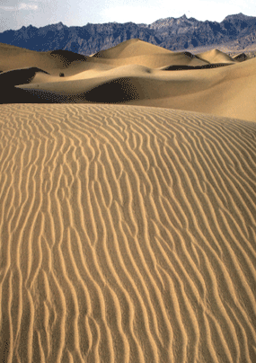
The final stop in my journey was the majestic Death Valley Dunes, which are surrounded on all sides by mountains. Consisting of tiny grains of quartz and feldspar, it was fascinating to learn of the formation of the dunes, starting from the tops of mountains as large chucks of rock that eventually find themselves as tiny grains of sand in the dunes, and how the winds play a major part in the formation of the smooth ripples that we see. I would be interested to learn what kinds of winds create the different types of dunes that we see, and if different wind strengths and/or directions affect what that section of the dunes looks like. Further, it fascinates me that this area is surrounded by mountain ranges - are the formations of those mountains unique enough that allow the dunes to exist, or if one of those formations had developed differently, would this area consist of something else?

Death Valley Dunes (Photo courtesy of NPS Archives)

References:
Artist's Drive. (n.d.). Retrieved from https://geomaps.wr.usgs.gov/parks/deva/ftart1.html
Death Valley Dunes. (n.d.). Retrieved from https://geomaps.wr.usgs.gov/parks/deva/ftdune1.html
Titus Canyon. (n.d.). Retrieved from https://geomaps.wr.usgs.gov/parks/deva/fttit1.html

Death Valley Field Trip- Mitchell Trenka


Death Valley Dunes


These sand dunes are created by the weathering and erosion. Flash floods actually help send a lot of water rushing down mountain slopes grinding the rocks even more. This dune field includes three types of dunes: crescent, linear, and star shaped. And the highest dune is around 100 ft. My question is how does all this sand stay in the same area why aren’t their just bare rocks instead of all that sand staying in one place.


Racetrack Playa

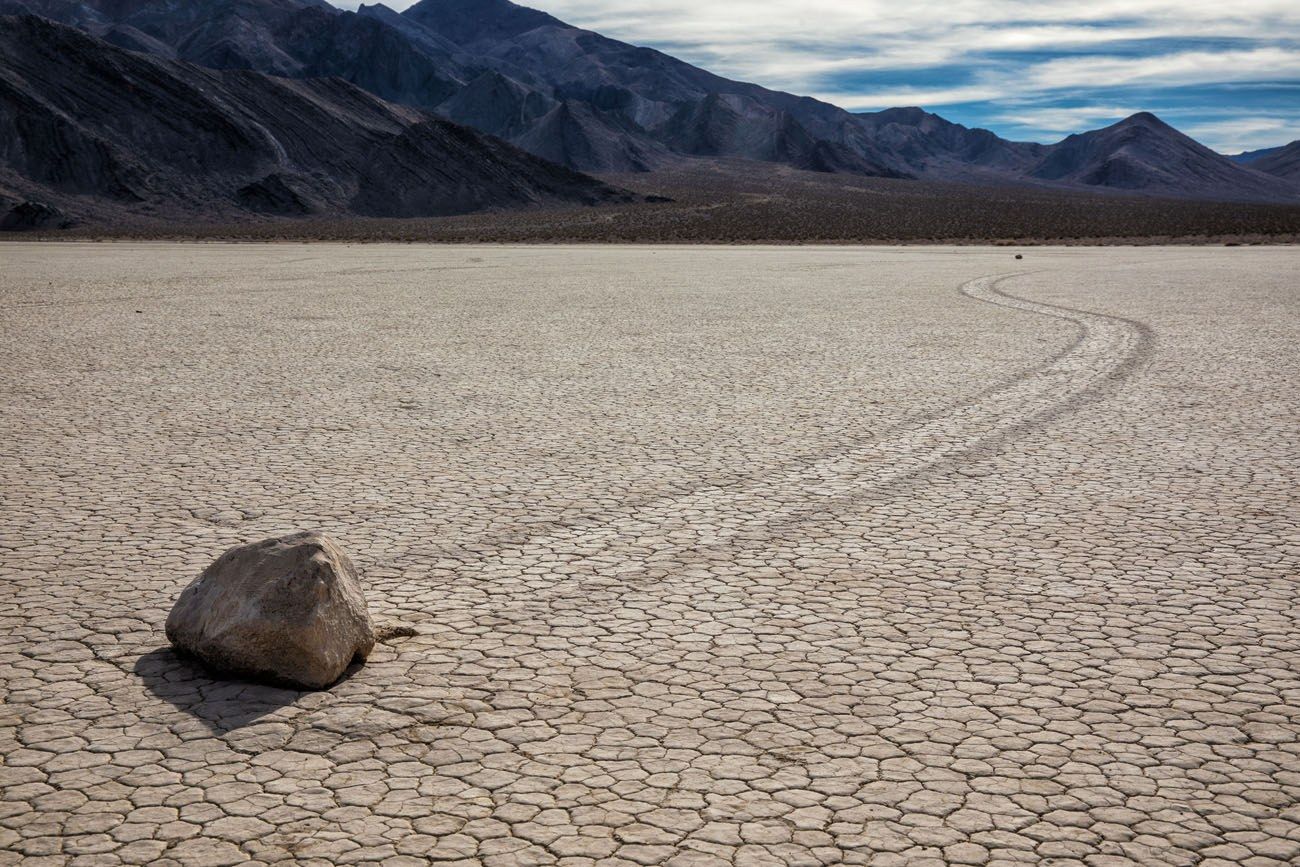
This area is located on a very flat dry lake bed burrowed in-between two mountain ranges. This dry lake bed has flashes of life when heavy rain-washed water down from the surrounding mountains forming a very shallow lake. This water then evaporates and leaves that cracked texture you see in the pictures. The thing that makes this place so interesting is the mysterious moving of rocks in this lake bed. There are rocks that have slid as much at 2900 ft. Yet no person has every seen these rocks move. My question is where do the rocks that slide actually come from in the pictures, I have seen it doesn’t seem to have an abundance of rocks.

Split Cindercone

Less than 300,000 years ago magma filled a chamber underneath the earths crust. That magma began to rise up taking advantage of weaknesses found in the crust. Once it made its way out it created a fiery eruption sending molten basalt everywhere. Mu question is if this volcano is still active or has the chance to become active again. I also would like to know the rock types found around the cone.


Week 7, Field Trip Travel Journal: Death Valley - Jon Morris


Being from California, how could I resist the call to find out what Death Valley is all about.  I would guess that just about everyone that is native to California has heard about Death Valley, and it had a formidable name, but I had a desire to find out what it is about this region that caused it to be called Death Valley.  Being the curious person that I am, I decided to look into it.  I was somewhat surprised to find out that Death Valley was given its name by a group of pioneers that were lost there in the winter of 1849-1850.  The National Park Service let me know that although only one of the group of pioneers died there, they had all assumed that the valley would be their grave ("Frequently Asked Questions - Death Valley National Park (U.S. National Park Service)", 2018).

Once I had learned about the origin of the name, I just had to see it for myself and so I packed up the family and we travelled together to Death Valley National Park to check it out in person.  The first stop we made was to examine Titus Canyon.  Titus Canyon looks like it is a big gash cut into the Grapevine Mountains, as we can see from the below picture.  We found this interesting in light of our trip to the Grand Canyon last year.  We wondered if it was the same forces that cause this canyon, or rift, to form or if it was due to something else?  Based on what I understand about Geology, I would tend to assume that the Titus Canyon was formed by water somehow, but where is the water or where did the water come from?  I know that no river flows through it, so I believe that the canyon was formed with water from some source at some point in time, and I would like to figure out where the water came from that eroded this giant gash in the midst of the Grapevine Mountains.

Here is a picture of Titus Canyon taken by Marli Miller:


Credit:  Marli Miller.


The second place we visited was called Dante’s View.  We learned that Dante’s View is on the north side of Coffin Peak, along the crest of the Black Mountains, overlooking Death Valley.  We learned that Dante’s View is a part of the Black Mountains, which is a part of the Amargosa Range, and was created when the surface of the Earth was being stretched, which ruptured the crust and caused lava to erupt over the sedimentary rock.  As we can see from the below picture, Dante’s View provides a truly unique view of what I would classify the “Basin” of Death Valley.  I know that the basin was created due to a stretching of the land, but I would like to know whether or not the stretching we can observe also resulted in any major faults?  Based on my personal visit and the pictures I was able to access, I am not able to determine whether or not there are any faults nearby or within the basin.

Here is a picture of Dante’s View taken by Marli Miller:

CreditMarli Miller.


The final place we visited on our trip was called Zabriskie Point.  This was really a neat location where we were able to see, what for us, was a very unique example of geology.   Zabriskie Point overlooks what are commonly referred to as badlands.   Badlands are described as being a place where everywhere you see dry, finely-sculpted rock.  Looking at the below picture, one would almost think that it looked like it was covered in snow and ice.  I was able to find other pictures that make it appear more like what one would expect:  golden tan folds intersecting each other.  I have included the additional photo under the original photo from the travel guide.  Seeing all of the folds, it makes me wonder what it was that caused the folds?  I know that folds are caused through a variety and conglomeration of factors, such as stress, pressure, and temperature.  I do know that most folds are caused by compressional stress, so it would be interesting to see if that holds true in this case.  Was it strictly stress or pressure that caused these folds, or were there multiple factors that played into it?


Credit: Badlands topography. Photo by Paul Stone, USGS


Frequently Asked Questions - Death Valley National Park (U.S. National Park Service). (2018). Retrieved from https://www.nps.gov/deva/faqs.htm


Week 7- Death Valley

For week 7, we took a field trip to a place that has always been on my bucket list: The Death Valley. This place is so interesting to me because it is made up of so many different regions in one large area.  The region that really interested me the most was the Death Valley Dunes which are made up of the Cotton Wood Mountains that surround them on both sides. I think it is simple fascinating how sand starts out as a large rock and is crushed through a process by wind, rain, and tiny pieces of crushed rock overtime. It is interesting to me because it is so soft yet created by something hard and brittle. I had a few questions about wind storms, I have seen in movies people almost being swept away because they are so powerful, I want to learn more about them and also how they effect the beautiful sand ripples forming perfect patterns. 


Ripplemarks on Death Valley Dunes


Death Valley Dunes

Frank, D. (n.d.). Death Valley geology field trip. Retrieved from https://geomaps.wr.usgs.gov/parks/deva/ftdune1.html

Week 7 Death Valley - Cobe Karhoff

Sinuous, water-sculpted curves of Mosaic Canyon marble
Mosaic Canyon

The first stop I visited was the Mosaic Canyon in Death Valley. As you can see in the photo, there are deep cuts in the mountain called Tucki Mountain. This canyon is made up of marble and the cuts are created from faults and also erosion. One question I have is how often does this canyon get eroded since Death Valley is a desert and rarely rains there.

Ubehebe and little Hebe craters
Ubehebe Crater
The second stop is Ubehebe Crater, which is considered a volcano at one point in time due to the thin layer of the crust allowing magma to seep through the faults and cracks on the crust. The question I would ask about this site is how often does this area get earthquakes? I never knew death valley had volcanoes located in the park, but now that I do know, I am curious to know how often earthquakes occur.


Polygonal cracks in salt pan
Badwater
My final stop is at Badwater, which is below sea level and the lowest point in the Western Hemisphere. The surface is made up of billions of crystals of almost pure table salt. The salt is created due to the dryness in the area and the salt is about 3-5 inches thick. My question about this stop is are there any volcanoes or any magma seeping through the crust since this area is below sea level.

Week 7- Field trip to Death Valley

Badlands topography


At the Badlands looking out from Zabriskie Point, with sediments of silt and clay create this beautiful effect that to me resembles waves. The multi color tops and and various sizes of these mounds brings me to the question: What is the average rain fall here? If is constant rain then it would have to cause a huge muddy mess? I would check the annual rain fall and then check how far the nearest town is to figure out how they prevent themselves or at all if flooding were to occur.
Shorelines etched into Shoreline Butte.

Shoreline Butte is the next stop we arrive to. The beautiful greenery and seeing the strandlines that are carved into the ground from the waves that once battered the shore. This brings me to a question of the history of all the lakes in the Death Valley thousands of years ago and how they have evaporated. How does the park keep them from getting filled back up? I would dive deeper into the Death Valley lakes and look at these on a topographic map to see the elevation and the surrounding around these lakes to get my answer.

Sinuous, water-sculpted curves of Mosaic Canyon marble

The last stop I would like to know more about is the Mosaic Canyon.The Sinuous, water sculpted curves of Mosaic Canyon marble. This place is breathtaking and I am in utter shock about how this canyon was formed millions of years ago. My question would be what type of fault is this canyon on for it to form the way it did millions of years ago? Would it change again if the fault that it was or still is on moves?


Week 7 - Meagan Valero

Mosaic Canyon


I would like to start by visiting Mosaic Canyon. You can clearly see the different layers of strata deposited over time here. They seam to be fairly uniform in their color, which leads me to decide that the geological activity and types of rock being deposited over time must have been fairly consistent. I would like to know what process lifted or weathered down these rocks so the strata are visible, and whether or not that process is still occurring today.


Split Cinder Cone


Here we see split cinder cone. I wonder what process caused this region to be elevated above the surrounding area. As you can see, a fault line runs through the center of the cone. I would like to know what kind of fault this is, and whether it is caused by tension or compression.

Titus Mosaic


Titus Mosaic is my favorite stop on the virtual tour. Here we see dark grey, angular rocks deposited in a sandy, light brown sediment. I wonder how these large grey rocks came to be composed differently than their surrounding sediment. I'd like to know exactly what the differences are between the makeup of the light grey sediment and the larger grey rocks so I can understand the various ways they formed.

Week 7 - Eric Valero

Artist's Pallet
My first stop is at Artist's pallet. Looking at these deposits, a number of colors are visible. I would want to know what minerals cause the color variations. I suspect that a number of salts and minerals are deposited by rains and flash flooding, but I can't know for sure what causes the coloration without studying the composition up close. It is interesting that these bright colors are at the base of a hill, which leads me to think that the water brings minerals from above down to mix at the base. I wonder why the colors aren't more prevalent at the top of the mountain if that's where the minerals come from.
Golden Canyon

Here at Golden Canyon we can clearly see stratified rock. I am curious as to if this rock was weathered by a stream in the area and if the stream is still present. There are obvious color variation between the strata near the top and strata at the bottom. I wonder what type of rock is near the base and why it is different from the rock near the top.
Mosaic Canyon
Here we see brightly colored, sharp rocks deposited among a sandy grey silt. I wonder how these sharp rocks got here, because most traveling rocks become more rounded by impacts over time. I also would like to know why they are so different from the surrounding silt, in order to explain the differences in color.